Augusta, Ontario - Augusta, Ontario
Augusta | |
|---|---|
İlçe (alt kademe ) | |
| Augusta İlçesi | |
 Kuzey Augusta | |
 Augusta | |
| Koordinatlar: 44 ° 45′04 ″ N 75 ° 36′01 ″ B / 44.7511 ° K 75.6003 ° BKoordinatlar: 44 ° 45′04 ″ N 75 ° 36′01 ″ B / 44.7511 ° K 75.6003 ° B | |
| Ülke | |
| Bölge | |
| ilçe | Leeds ve Grenville |
| Devlet | |
| • Tür | İlçe |
| • Reeve | Doug Malanka |
| • Federal binicilik | Leeds — Grenville |
| • Prov. binme | Leeds — Grenville |
| Alan | |
| • Arazi | 314,66 km2 (121,49 metrekare) |
| Nüfus (2016)[1] | |
| • Toplam | 7,353 |
| • Yoğunluk | 23,4 / km2 (61 / metrekare) |
| Saat dilimi | UTC-5 (Avustralya, Brezilya ve Kuzey Amerika ülkelerinin kullandığı saat uygulaması ) |
| • Yaz (DST ) | UTC-4 (EDT ) |
| Alan kodları | 613 |
| İnternet sitesi | www |
Augusta Kasabası bir kasaba içinde Birleşik Leeds ve Grenville İlçeleri doğuda bulunan Ontario, Kanada.[2] Augusta, Saint Lawrence Nehri ve kırsal mezralara kadar uzanır. İlçe, şehir arasında yer almaktadır. Brockville batıda ve kasabasında Prescott doğuya.
Augusta'daki mezralar ve köyler 1900'lerden önce kurulmuştu; öncelikle tarafından Birleşik İmparatorluk Sadık. Erken yerleşimciler tarafından inşa edilen ilçede bugün hala ayakta duran birçok bina ve ev var; Bu tarihi evlerin çoğu hala ilk yerleşimcilerin doğrudan torunları tarafından işgal edilmiş durumda.[3]
2013 yılında, adı geçen Kanadalı kölelik karşıtı Samuel Bass'in Süleyman Northup 1853 anısı 12 yıllık kölelik Augusta İlçesindendi.[4] Erken nüfus sayım kayıtlarına göre Bass, 1807'de Augusta'da doğdu;[5] buradayken Lydia Catlin Lane ile evlendi,[6] onunla dört çocuk babasıydı.[7] Eşi ve çocukları bölgede kaldı,[8] ve torunlarından bazıları bugün hala burada yaşıyor. Bass'ın büyükanne ve büyükbabaları bölgeye yerleşen ilk Sadıklar arasındaydı.[7] ve ailesi Maynard'a gömüldü.[9]
Coğrafya
Augusta Kasabası, St. Lawrence Ovaları bölge;[10] en güneydeki sınırı, St. Lawrence Nehri'nin kıyısıdır. Alanın çoğu, 500 ila 75 milyon yıl önce, bu dönemde oluşan büyük kireçtaşı ve gri kumtaşı katmanlarının üzerinde yer almaktadır. paleozoik dönem ve Ordovisyen dönemi.[11] Ordovisyen dönemini doğrudan takip eden dönem hakkında, deniz istilalarının ardından gelen uzun erozyon dönemleri dışında pek bir şey bilinmemektedir. Son buzullaşma, günümüz peyzaj özelliklerinin çoğundan sorumlu olan yaklaşık bir milyon yıl önce meydana geldi. Bu buzullaşma sırasında Augusta'ya dönüşecek olan bölgenin tamamı iki ila üç mil kalınlığında bir buz tabakasıyla kaplıydı. Bu buz tabakası, iklim değişikliklerinin bir sonucu olarak yaklaşık 12.000 yıl önce eridi. Ottawa-St eritildikten birkaç bin yıl sonra. Lawrence Vadisi, Atlantik Okyanusu'nun bir kolu tarafından yaklaşık 120 m derinliğe kadar sular altında kaldı; jeologlar bu selden Champlain Denizi. Champlain Denizi'nin yaklaşık 9.500 yıl önce geri çekilmesi, birçok bölgede aşırı taş yüzeyler bıraktı. İlçenin doğu kısmındaki ana kaya ve kaya kili, muhtemelen buzul-akarsu kökenli olan kum yataklarıyla kaplıdır; orman kök salmadan önce Prescott kasabasının hemen kuzeyinde birçok kum tepesi oluştu. Alanın kıyıları etrafında birçok kil ve turba cepleri vardır. Güney Ulus Nehri ve Güney Kemptville Deresi.[11]
Topografya
Augusta ilçesi, üç farklı fizyografik bölgenin kesiştiği yerde bulunmaktadır: Glengarry'den ovaya kadar, Smiths Falls kireçtaşı ovası ve Edwardsburgh kum ovası.[12] Kireçtaşı ovası ilçelerin toplam alanının yaklaşık% 50'sini oluşturmaktadır. Bu alan, ince bir toprak örtüsüyle düzdür, derinliği bir ayaktan daha azdır ve bu da kireçtaşı çıkıntılarına neden olur. Kireçtaşı ovası, en baskın tür olan şeker akçaağacıyla bir sert ağaç ormanını destekler. Meşe ve çam da bu bölgede yaygındır, drenajı zayıf olan bölgelerde karaağaç, dişbudak, yumuşak akçaağaç ve sedir. Bu arazi çiftçilik için ideal değildi ve büyük ölçüde el değmemiş kaldı; ovanın çoğu hala turba yatakları ve ormanlarla kaplıdır.[12] Edwardsburgh kum ovası doğudan ilçeye kadar uzanır. Su tablası genellikle bu ovada yüzeye yakın konumlandırılarak sığ bataklıklara neden olur. Alanın çoğu temizlendi, ancak bir zamanlar bu bölgede karaağaç, dişbudak, kayın, meşe ve yumuşak akçaağaç büyüdü. Bugün, bölge Limerick Ormanı gibi çam ağaçlarıyla bir şekilde yeniden ağaçlandırılmıştır.[12] İlçenin önü Glengarry'den düzlükle kaplıdır, bu da St. Ottawa havzalar. Bu kadar doku ve taşta tınlı olarak tanımlanabilir. Glengarry'nin ovaya kadar iyi drene edilmiş bölümleri tahıl mahsulü üretimi için uygundur.
Nation Nehri boyunca topraklar, yetersiz drenaj nedeniyle çoğunlukla bitki maddesini içerir ve bu nedenle kullanımları sınırlıdır. Bölgedeki yetersiz drenajın bir başka etkisi de ilçede yaygın olan ve sıklıkla drene olan büyük bataklıkların oluşmasıdır.[12] Tüm ilçedeki topraklar, ilçenin çeşitli fizyografik bölgeler içinde yer alması nedeniyle büyük ölçüde değişir; Augusta'daki en yaygın iki toprak, Podzolic ve Gleysolic'dir. Podzolik topraklar doğurganlık açısından düşük ve asidiktir, Gleysolik topraklar ise tarımsal değer bakımından yüksektir.[12]
İklim
Augusta Kasabasının iklimi enlemine göre belirlenir, ancak kuzey ve güneyden gelen hava kütlelerinin sonucu olan ön sistemlerden büyük ölçüde etkilenir. İlçeyi etkileyen en yaygın rüzgar sistemi batı rüzgarlarıdır. Augusta'nın iklimi, ortalama sıcaklık aralığı ile nemli kıta olarak tanımlanabilir; Sıcaklık aralıkları ortalama en düşük -8,4 ° C'den (16,9 ° F) ortalama en yüksek 20 ° C'ye (68 ° F) kadar değişir.[13] Augusta ilçesinde yıllık ortalama yağış miktarı yıllık 96,8 santimetre (38,1 inç) civarındadır. İklim 1850'den beri büyük ölçüde değişti. 1550'den 1850'ye kadar bölge küçük bir buzul çağının pençesindeydi; ortalama sıcaklıklar çok daha soğuktu ve daha fazla yağış vardı. 1885'e gelindiğinde, yirminci yüzyılın ortalarına kadar süren bir ısınma eğilimi başladı.[13]
Tarih
Augusta kasabası, 1700'lerin sonlarına ve 1800'lerin başlarına kadar tam olarak yerleşmemişti, burada Sadıklar bölge boyunca arazi hibelerini aldılar ve çiftlik evleri inşa etmeye başladılar. Bugün kasabada yaşayan sakinlerin çoğu bu Sadıkların doğrudan torunlarıdır. Bundan hemen önce 1700'lerin ortalarından sonlarına kadar, Fransızlar, Maitland, Ontario'daki Pointe au Baril de dahil olmak üzere bölgedeki bazı toprakları işgal etmişti. Avrupa yerleşiminden önce, birçok yerli birey kültürü tüm bölgeyi kısaca işgal etti.
Tarih öncesi dönem
Arkeologlara göre Augusta ilçesini kapsayan bölgedeki en eski insan etkinliği, yaklaşık 11.000 yıl öncesine kadar izlenebilir. Paleo-Hint dönemi olarak bilinen bu çağda, geri çekilen buzullar ilk kez yaşanabilir arazileri açığa çıkardı. Bu dönemde bu bölgede yaşadığına inanılan kültürler Clovis halkı ve Plano halkıdır.[14] Bu kültürler, varlıklarına dair çok az kanıt bıraktılar; Nüfus yoğunluğu çok düşük olduğu için alan üzerindeki etkileri nispeten küçüktü. Bu dönemden hiçbir insan kalıntısı hayatta kalamadı, yani Clovis veya Plano'nun fiziksel görünüşünü belirleyemeyiz.[14] Doğu Ontario'nun bu bölgesinde bu kültürlerin yaşadığını gösteren en büyük kanıt, bölgede keşfedilen ve bu kültürlere atfedilebilecek ve döneme tarihlenebilecek sayısız taş ok ucu ve diğer silahlardır.[15] İlçenin yakınında bulunan Clovis ok uçları, yüzyıllarca süren ilerlemeyi ve hızla değişen bir ortamı yansıtan inşaat açısından büyük farklılıklar gösteriyor. Daha önceki oklar daha kısaydı, daha sonra Clovis okları daha uzun ve mızrak benzeri idi; Bu, daha büyük hayvanların bölgeye kitlesel göçünün bir göstergesidir.[16]
Arkaik Dönem olarak bilinen dönemde MÖ 5000'den 1000'e kadar, Doğu Ontario'nun tüm bölgesi, Plano kültürünün doğrudan torunları olan Laurentian Arkaik halkının hakimiyetindeydi.[15] Bu kültür, daha sıcak iklim ve modern flora ve faunanın ortaya çıkışı nedeniyle atalarından çok daha karmaşıktı; Hem avcılık hem de ağaç işçiliği için yontma aletler yerine cilalı taş aletler kullanılmıştır.[14] Laurentian Arkaik kültüründen insan kalıntıları hayatta kaldı ve arkeologlara göre kültürün hem şiddetli hem de ritüelleştirilmiş olduğunu belirtiyor. Bu dönemden bulunan bazı cesetlerin kafatası kırıkları, kemiklere gömülü taş mermilere sahip olduğu veya başlarının kesildiği tespit edildi.[14] Diğer cesetlerin kırmızı aşı boyası serpildiği ve görünüşe göre kişinin kültür içindeki statüsünü temsil ediyor gibi görünen çok çeşitli mallarla gömüldüğü bulundu. Laurentian Arkaik halkının yanına gömülen bazı eserler bu bölgeye özgü değil, yani Laurentian Arkaik halkı kendi kültürlerinin dışındaki kişilerle mal ticareti yapmış olmalı. Arkeologlar, ritüelleştirilmiş cenaze törenlerinin yanında bulunan acımasız kalıntıların, Laurentian Arkaik halkını tehdit eden, saldıran veya başka bir şekilde zarar vermiş olabilecek dış tüccarlara ait olduğunu varsayıyor.[14]
Yaklaşık 500 yıl önce, Augusta Kasabası haline gelecek olan bölgede, yaklaşık 1.600 kişilik bir nüfusa sahip İrokoylu bir tarım topluluğu yaşıyordu.[17] Ana yerleşim yeri, günümüz Roebuck, Ontario'nun biraz kuzeyinde, Indian Creek yakınlarında yer almaktadır. Bu alanda yapılan arkeolojik kazılar, köylerinde yaklaşık 100 fit uzunluğunda uzanan yaklaşık 40 ortak uzun ev olduğunu göstermektedir. Yerli Iroquoian çiftçileri mısır, fasulye, kabak, ayçiçeği ve tütün yetiştirdiler.[17] Roebuck'ta bulunan köyün, 1535'te Jacques Cartier tarafından ziyaret edilen bugünkü Montreal'de bulunan yerli köy olan Hochelaga'ya benzediğine inanılıyor.[17] Avrupalı yerleşimciler geldiğinde, yerli nüfus her şeyden önce istikrarlı bir şekilde azalmaya başladı, ancak kasabadan kayboldu. Avrupa yerleşiminden kurtulanların Trent Nehri sistemi boyunca yer alan Huronlar tarafından emildiğini gösteren bazı arkeolojik kanıtlar var.[17]
Fransız dönemi
On sekizinci yüzyıl, Augusta Kasabası olacak olan yerde bir Fransız işgaline tanık oldu. İlçe, o zamanlar yaygın bir ticaret yolu olan St. Lawrence Nehri boyunca elverişli bir konuma sahiptir; Günümüz Montreal'inden Fort Frontenac'a (şimdi Kingston) seyahat etmek için günümüzün Augusta'sından geçmek gerekir. Fransızlar, St. Lawrence boyunca çeşitli ticaret noktalarında yerli halkla ticaret yaptılar; değerli kürkler Fransa'ya geri ihraç edildi.[18] Fransızlar nihayetinde nehrin akıntılarını seyredebilecek gemiler inşa etme niyetiyle bir tersane kurdu. Tersane, Fransızların bugünkü Maitland, Ontario olan Pointe au Baril olarak adlandırdığı yerde bulunuyordu ve amaçları için ideal korunaklı bir körfezin yanı sıra gemi yapımı için hasat edilebilecek kalın bir meşe ve çam ormanına sahipti.[18] İngilizlere karşı korunmak için Fransızlar ayrıca Pointe au Baril'de yıldız şeklinde bir kale kurdu. Fransız tersanesine iki gemi inşa edildi. İrokuaz ve OutouaiseHer ikisi de 1759 civarında inşa edilmiş ve başlatılmıştır.[18] Ertesi yıl, Fransız yerleşim yeri ve gemiler General Amherst tarafından ele geçirildi ve Fransızlar yerleşimi terk etmek zorunda kaldı. Bundan sonra Pointe au Baril, yirmi yıl boyunca terk edilmiş olarak kaldı; Bölgeyi kolonileştirmek için hiçbir girişimde bulunulmadı ve kale içinde yaşayan işçiler hem yerlilerden hem de İngilizlerden bıkmıştı. Sadıkların gelişi üzerine, Fransız işgalinden geriye sadece bir bina kaldı, bir zamanlar subay mahallesi olan tek bir kütük bina. Bina, ilçenin ilk okul binasına dönüştürüldü.[18]
Sadıklar
Amerikan Devrim Savaşı sırasında, Amerikan kolonilerinin sakinleri siyasi olarak bölünmüştü; birçok Amerikalı İngilizlerden hoşnut değildi ve İngiliz yönetiminden bağımsız olmaları için çabalıyordu. Bu siyasi kargaşa döneminde, İngilizlerin yanında yer alanlar hain veya isyancı olarak görüldü ve muhalefetleri şiddetle karşılandı.[19] Tarafsız partiler bile isyancı olarak görüldüğü için bireyler taraf olmaya zorlandı. Taca sadık kalanlara Sadıklar deniyordu. Savaş sırasında ve sonrasında, Sadıklar, muhalif görüşleri nedeniyle esasen günümüz Amerika'sından çıkarıldılar ve gidecekleri bir yer olmadığı için muhtaç bırakıldılar; daha sonra rahatlamak için İngilizlere döndüler. Başlangıçta, Sadıklar Britanya'nın isyan eden kolonilerle başarılı bir şekilde müzakere edebileceğinden ve topraklarının, evlerinin ve mallarının kendilerine iade edileceğinden umutluydu.[19] Bu tür müzakereler hiçbir zaman gerçekleşmedi ve savaşın sona ermesiyle askeri ödemeler azalıyordu. New York eyaletinde, Sadıkların mülklerine resmi olarak el konulmasına izin veren yeni yasalar çıkarıldı ve geri dönmeye çalışabilecek Sadıkların hayatları için tehditler yapıldı. Sadıkların İngilizlere güvenip bugünkü Augusta ve komşu kasabalara geri dönmekten başka seçenekleri yoktu.[19]
Britanya'nın yaygın yoksulluk ve evsizliğe çözümü, Sadıklara yeni yerleşim yerleri inşa etmek ve yeniden başlamak için kullanılabilecek arazi hibeleri sağlamaktı.[19] Bu bağışlar aynı zamanda erkeklerin krallığa olan sadakatinin bir ödülü olarak da görülüyordu. Başlangıçta, Quebec bölgeleri bölünme ve Loyalistlere dağıtım için düşünülüyordu; Quebec, Sadıkların bölgeyi olumsuz etkileyeceğinden ve kızamık gibi hastalıkları toplumlarına getirebileceğinden korktu, bu yüzden fikir terk edildi.[19] Quebec'in genel sörveyörü Binbaşı Samuel Holland, Quebec'in batısındaki arazileri araştırmakla görevlendirildi ve yerleşim için uygunluklarını değerlendirdi. 1783'te Hollanda, arazinin Sadık yerleşim yerleri için fazlasıyla yeterli olduğunu ilan etti. Sadıkların arazi bağışlarının önündeki tek engel Augusta'nın yerli nüfusu idi; İngiltere, toprağı bölerken toprak mülkiyetini dikkate almak zorunda kalacaktı. Sir John Johnson adlı bir adama, hangi toprakların yerli topluluklara ait olduğunu sorması ve kendilerine ait olduğunu iddia ettikleri herhangi bir araziyi satın alması talimatı verildi. Bölgede kalan Yüzbaşı Justus Sherwood, Augusta ve çevresindeki ilçeler hakkında ayrıntılı bir araştırma yapmak için görevlendirildi.[19]
1784'e gelindiğinde, Sadıklar gittikçe huzursuz oluyordu ve hükümete bu çetin durumlarından kurtulmak için dilekçe vermeye başladı; 1784 Baharında yerleşmeleri planlanıyordu.[19] Yerine getirilmesi gereken uzun bekleme süresi, kısmen, hükümetin Sadıklara kendilerini idame ettirebilmeleri için bazı araç ve gereçler sağlamaları gerektiğini bilmesinden kaynaklanıyordu. Hükümet, her yerleşimciye tarıma başlaması için bazı tohumlar ve çiftlik hayvanlarının yanı sıra baltalar, bıçaklar ve çapalar gibi birkaç temel alet sağlamayı amaçladı. Yerleşimci grupları arasında paylaşılmak üzere marangozluk ve demircilik aletleri de dağıtılacaktı. Arazi hibeleri, askeri konum ve rütbeye göre verilecekti.[19]
1784 baharında erzak toplanmış ve arazi detaylı bir şekilde araştırılmış ve çekilmek üzere partilere bölünmüştü. Batteaux ve erzak, Sadık yerleşimcilerle birlikte yeni yerleşim yerlerine taşınmaya hazırdı.[19] Günümüz Augusta Kasabasını çevreleyen alan, ilki Kraliyet Kasabaları olarak adlandırılan iki ilçeye bölünmüştür. Yedi Kraliyet Kasabası vardır, Augusta yedinci ve Royal Township Number Seven başlıklı.[19] Sonunda, kasabalar Augusta olarak adlandırıldı. Prenses Augusta üçüncü kızından sonra Kral George III. Çoğunlukla vahşi doğadan ibaret olan bu kasaba fikrinin kendisinin adını alması onu "özellikle heyecanlandırmadığı" söylendi.[19] Haziran 1784'te, Sadıklar nihayet Quebec'ten St. Lawrence Nehri'nin aşağısındaki yeni yerleşimlerine doğru yola çıktılar; Edward Jessup'ın Kolordusu, yeni Kraliyet Kasabası'nın ilk yerleşimcileri olacaktı.
Eğitim
Tarih
Augusta'da kurulan bilinen en eski okul, Maitland'da bulunan Johnstown Dilbilgisi Okulu'dur. 1788 civarında inşa edilmiş basit bir kütük yapısıydı ve muhtemelen o sırada bölgedeki tek okuldu.[20] 19. yüzyıla kadar bile, ağırlıklı olarak kırsal kasabadaki çiftçi aileleri örgün eğitimde çok az değer gördüler. Bir çocuğun birincil sorumlulukları ailelerini ve çiftliğini içeriyordu, bu nedenle o sırada var olan birkaç okula kaydolan birkaç öğrenci, sorumluluklarının izin verdiği ölçüde ara sıra gidiyordu.[21] O dönemde okulları çevreleyen genel ilgisizliğin yanı sıra, mali kısıtlamalar da resmi bir eğitim sisteminin kurulmasını engelledi; ilkel bir okul inşa etmeyi başardığında bile, öğretmenlerin maaşları veya uygun metinler ve sınıf araçları için çok az para vardı veya hiç yoktu.[20] Bu ilk okul evleri basit, kütük yapılardı, gönüllü çiftlik işçileri tarafından inşa edilmiş ve çoğunlukla ücretsiz bulabildikleri şeylerle yapılmıştı; bu yapılar tuvaletler ve zeminler gibi temel ihtiyaçlardan yoksundu ve genellikle yosun ve kirle kaplanmış deliklere sahipti.[20]
1816'da Yukarı Kanada'da Ortak Okullar Yasası yürürlüğe girdi; bu Yasa, her bir öğretmenin ücretinin ödenmesi için 25 sterlinlik hibe dağıtılmasını ve ilçenin okul bölümlerine bölünmesini gerektiriyordu.[22] Bölümler, yaklaşık 20 öğrencinin kolaylıkla bir araya gelebileceği yerlere göre belirlenecekti. Yasa bölge için bazı iyileştirmeler sağlasa da, inşaat malzemeleri veya sınıf malzemeleri için hiçbir mali yardım yoktu, bu nedenle hibeler yerleşimcilerin okul kurmaları için çok az teşvik sağladı. Augusta Kasabasında eğitim açısından önemli ilerleme 1800'lerin ortalarına kadar gerçekleşmedi. 1844 yılına gelindiğinde, kasaba başarıyla 22 okul bölümüne ve birden çok ilçeden öğrencilerle komşu ilçelerle birlik bölümleri olan 5 bölüme ayrıldı.[23] Orijinal bölümler ve okullar aşağıdaki gibiydi:[24]
|
|
|
|
|
|
Her bölümün, genellikle yerel olarak çıkarılan taştan yapılmış ve yerel aileler tarafından inşa edilmiş kendi okul binası vardı. Bu tek odalı okul evleri, tek odalı ayrı okulların ve okul bölümlerinin büyük ölçüde kaldırıldığı 1950'lere kadar bölgede kullanıldı. Eski okul evlerinin çoğu hala ayakta ve o zamandan beri özel konutlara dönüştürülüyor.[24] S.S. # 22, # 29 ve # 32 hiç gelişmemiş planlanmış bölümlerdi; 26–28 okul kesimlerinin neden olmadığı açık değil.[25] S.S. # 16, Merwin Lane'de bulunan, görünüşe göre isimsiz bir bölümdü. Bu okul kütükten inşa edilmişti ve Brundage's School ile birleştirildiğinde 1872 yılına kadar açıktı; Bu kütük yapısının kalıntıları 1900'lerin başlarında vardı.[25] S.S. # 19 Pepper's School, North Augusta ve Garretton arasında, Walling'in 1861 haritalarında ortaya çıkması dışında neredeyse hiçbir kaydı olmayan küçük bir bölümdü.[25] S.S. # 15 Brown's School, Throoptown topluluğu için ayrı bir okuldu, ancak bu okulla ilgili delirmiş birkaç ödeme kaydı dışında çok az kayıt var; ayrıca Throoptown'da ayrı bir Roma Katolik okulu vardı.[25]
1950'lerde ve 60'larda ulaşım geliştikçe, daha küçük okullardan öğrencileri birleştirmek için merkezi yerlerde daha büyük devlet okulları inşa edildi. Bu büyük okullar, önceki okullardan çok daha moderndi; Bu dönemde ilçede bu büyük okullardan birkaçı inşa edildi ve bunlardan sadece biri hala çalışıyor. 1955 yılında, Churchill Devlet Okulu, Merwin Lane'in güney ucunda, şimdi Riverview Heights topluluğu olarak kabul edilen yerde açıldı. Çelik iskeletli büyük bir tuğla binaydı ve dört sınıf içeriyordu; daha sonra okula bir spor salonu ve mutfak eklendi. Bu okul, Mavi Kilise okulunu, Haley'in okulunu ve eski Maitland okul evini birleştirdi ve hepsi tamamlandıktan sonra kapatıldı.[26] Okul, 1974'te kapılarını kalıcı olarak kapattı. Algonquin Devlet Okulu, Ontario, Algonquin köyünde bulunan bir tuğla yapıydı. İlçede orijinal planlara bir spor salonunun dahil olduğu ilk okuldu.[27] Okul altı sınıf içeriyordu ve ortalama 130 öğrencisi vardı. Algonquin Devlet Okulu, Herron'un okulunu, Read'in okulunu ve okul evlerini Lord's Mills ve Algonquin toplulukları için birleştirdi ve sonuç olarak kapatıldı.[27] Algonquin Devlet Okulu 2000'li yıllarda faaliyetlerini durdurdu ve bina şu anda emeklilik tesisi olarak kullanılıyor. Maitland Devlet Okulu Maitland, Ontario'daki Maitland Yolu'nun hemen batısında yer almaktadır. Bu devlet okulu 1955 civarında inşa edildi ve yakın tarihte kapatıldı. Bina o zamandan beri yıkıldı.[28] Maynard Devlet Okulu 1958 yılında inşa edilmiştir ve ilçede halen faaliyette olan tek devlet okuludur. Başlangıçta, okulda daha fazla sınıf oluşturmak için 1964, 1967 ve 1969'da okula eklemeler eklenmeden önce sadece altı oda, bir müdürün ofisi ve bir yönetim kurulu odası vardı.
Eskiden Augusta ilçesinde özel bir okul vardı. Grenville Hıristiyan Koleji. Ontario Highway 2 üzerinde bulunan okul ilk olarak St. Mary's Redemptorist Koleji 1920'de ilk açıldığında;[29] Orijinal yapının inşası 1918'den başlayarak yıllarca sürdü.[30] 1973'te okul satıldı ve karma bir özel gün veya yatılı okul oldu. Okul, belirsiz mali sorunlar nedeniyle 2007 yılında kapandı; kapatılmasından bu yana, okulu çok tartışmalara çevirdi. Birçok öğrenci, eski personelden taciz iddialarıyla öne çıktı.[31][32]
Günümüz
Günümüzde, Augusta ilçesi sınırları içinde yalnızca bir ilkokul bulunmaktadır: Maynard, Ontario'da bulunan Maynard Devlet Okulu. İlkokul öğrencileri ya Maynard'daki okula gidebilir ya da oradaki ilkokullara gitmek için Prescott ya da Brockville'e nakledilebilir. İlçede ortaokul yoktur; ancak, Prescott ve Brockville'de bulunan ortaokullar Augusta Kasabasında yaşayan öğrencilere hizmet vermektedir.[33]
| Çalışma alanı | Numara | Yüzde |
|---|---|---|
| Sağlık meslekleri veya ilgili programlar | 555 | 17.8% |
| İşletme, yönetim, pazarlama ve ilgili destek hizmetleri | 500 | 16.1% |
| Eğitim | 215 | 6.9% |
| Mekanik ve onarım teknisyenleri / teknolojileri | 215 | 6.9% |
| İnşaat / ticaret | 200 | 6.4%[34] |
2011 yılında, Augusta'da yaşayan 25 yaş üzeri 5,365 yetişkinin% 51,8'i bir tür orta öğretim sonrası eğitimi tamamlamıştı. Bu bireylerin% 16.9'u üniversite diploması veya sertifikası,% 29.4'ü üniversite diploması ve% 11.8'i esnaf sertifikası almıştır. Yetişkinlerin toplam% 26,1'i en yüksek eğitim düzeyi olarak lise eğitimi almış ve yetişkinlerin% 15,8'i ne orta öğretim ne de orta öğretim sonrası eğitimini tamamlamıştı.[34] Kasabadaki yetişkinler arasında en yaygın çalışma alanı sağlıkla ilgili mesleklerdir.[34]
Topluluklar
İlçe, Algonquin, Bisseltown, Blue Church, Centre Augusta, Charleville, Domville, Garretton, Glenmore, Herron's Corners, Limerick Ormanı, Lords Mills, Maitland Maynard, McLeanville, McRobert Köşesi, Kuzey Augusta, Perrin's Corners, Riverview Heights, Roebuck, South Augusta, South Branch, Sparkle City, Stone's Corners ve Throoptown. 1834'ten önce Prescott, Augusta Kasabasının bir parçası olarak kabul ediliyordu; kasaba bir polis köyü o yıl Augusta ile bağlarını kopardı. 1849'a gelindiğinde, Prescott resmen bugün kaldığı kendi belediye başkanı ve konseyi ile ayrılmış bir kasaba haline geldi.[35]

İlçe idari ofisleri Maynard'da bulunmaktadır.
Algonquin
Algonquin[36] Maitland'ın kuzeyinde yer alan küçük bir kırsal mezradır. Merkez konumu, Algonquin Road ve County Road 15'in kesişme noktasıdır, ancak Algonquin topluluğu olarak kabul edilen alan, dördüncüden yedinci tavizlere kadar uzanır.[37] 1800'lerin başında, burayı hibe olarak aldıktan sonra arazinin çoğuna sahip olan Wright ailesinden sonra köy, Wright'ın Köşeleri olarak anılıyordu. Wright ailesi, toplum içinde üretken, zengin ve sadık bir aileydi; bir han işletiyorlardı ve Augusta'da öğretmenlere ve Algonquin peynir fabrikasından işçilerin maaşlarını ödedikleri kaydedildi.[38] Postane kayıtlarına göre, 1860'larda mezra resmen Algonquin olarak listelendi.[39]
1800'lerin başında, Maitland'dan Rideau su yoluna kadar askeri bir rota araştırıldı. Bu, Algonquin bölgesinden daha fazla trafik geçmesine neden oldu ve köyün zenginleşmesine izin verdi.[38] Bu süre zarfında, posta arabası ile seyahat eden gece misafirlerini ağırlamak için Wright ailesi tarafından bir han kuruldu. Posta, bu sırada Maitland'dan haftada üç kez teslim edildi. Yüzyılın ortalarında, hana eşlik etmek için Algonquin'de birçok işletme açıldı. Bir bakkal, demirci, fıçı dükkânı, kasap, vagon imalathanesi ve Metodist kilisesi şu anda faaliyette olanlardan bazılarıdır. Ek olarak, topluluk bu süre zarfında kendi postanesini açtı. 1800'lerin sonlarına doğru Algonquin en zengin zamanındaydı; peynir fabrikaları ve bıçkıhaneler ve yerel işletmeler tam anlamıyla faaliyetteydi.[38]
Diğer tüm topluluklar gibi, Algonquin'in de S.S # 11 Algonquin Okulu olarak adlandırılan kendi tek odalı bir okulu vardı.[40] Okulun ilk kaydı, beşinci imtiyaz boyunca bir kütük yapısı olduğunu gösterdi. Bu ilk okul daha sonra odun kömürü için yakılmadan önce yerel bir adam tarafından bir makine barakası olarak kullanıldı. İkinci okul binası 1833'te inşa edildi ve bugün hala ayaktadır. Bu yeni okul binası taştan inşa edildi ve çan kulesi topluluk içinde yerel bir kişi tarafından inşa edildi ve o sırada öğrenciler tarafından ödendi. Bu okul, Eylül 1962'de Algonquin Devlet Okulu'nun açılışına kadar faaliyette kaldı. Tek odalı okul, daha büyük, daha yeni devlet okulunun aşırı kalabalığını hafifletmek dışında, eski haline geldi. Algonquin Devlet Okulu yakın zamana kadar faaliyette kaldı. Bölgeden gelen öğrenciler artık hem ilkokul hem de ortaokul eğitimi için komşu kasabalara taşınıyor.[40]
Algonquin, topluluğuna hizmet etmek için bir noktada üç kiliseye sahipti, en sonuncusu Union Grove kilisesi. Kilise, bir Wesley Metodist kilisesiydi ve 1892'de Lot 25'teki beşinci imtiyazla inşa edildi. Aynı parselde erken bir papaz evi vardı; Wesleyan Metodist kilisesinin mütevellileri bu niyet için 1841'de beş dönümlük arsayı yüz pound'a satın aldı ve 1858'e kadar mülkü elinde tuttu.[41] Arazi, 31 Ekim 1892'de bir Wm'den 1 dolara yeniden mütevelli heyeti tarafından satın alındı. Hornibrook. Çerçeve kilisesi inşa edildikten kısa bir süre sonra. Bu kilisede ayinler 1925'te kapanana kadar her Salı gecesi yapıldı. Yapı, daha sonra 1943'te kiliseyi yolun karşısındaki orijinal konumundan yeniden yerleştiren yerel bir sakin tarafından satın alındı. Kilise o yerde kalır ve o zamandan beri bir özel konut.[41] Algonquin'de inşa edilen en eski kilise, Bisselltown ve Maitland yollarının kavşağında bulunan bir Baptist kilisesiydi. Kilise, güney duvarındaki tarih taşına göre 1849 yılında yapılmıştır.[42] Kilisenin vitray pencereleri ve içeride bir balkonu vardı, aslında yapının önünde uzun bir sivri uçlu kare bir kule vardı. Bugün kilise beyaz sıva ile kaplanmış, kule ve kule kaldırılmıştır. Daha sonraki yıllarda kısa bir süre araba garajı olarak kullanıldığı için binanın ön cephesinde artık büyük bir garaj kapısı bulunmaktadır. Kilise daha önce kasaba tarafından bakım ekipmanlarını saklamak için kullanılmıştı ve bugün hala ayakta.[42] Ontario, Algonquin'deki üçüncü kilise Algonquin United Kilisesi'dir. Tarih taşına göre 1858 yılında inşa edilmiştir.[43] 1851'de ilk kilise inşası görüşmeleri başladı ve beş yıl sonra arazi satın alınarak inşaata başlandı. Yapımının ardından, 1880'lerde Algonquin Birleşik Kilisesi olmadan önce Wright's Corners Kilisesi ve daha sonra Maple Grove Kilisesi olarak anıldı.[43] Kilise, sonradan eklenmiş olduğu anlaşılan Gotik tarzı vitray pencerelere sahip taş bir yapıdır. Algonquin United Kilisesi bugün hala kullanılıyor.[43]
Bisselltown
Bisselltown[44] Ontario,[45] Augusta Kasabası içindeki Bisselltown Yolu üzerinde bulunan küçük bir topluluktur. Köy, toprak Sadıklar arasında bölündüğünde 1785 yılında kuruldu; Bunlardan biri, David Bissell adında ve on bir çocuğu, arazi hibesi yoluyla araziyi aldıktan sonra bölgeye yerleşti.[46] Çiftlikleri etrafında büyüyen küçük topluluk, Bisselltown olarak tanındı. On sekizinci ve on dokuzuncu yüzyılda Bisselltown'da hangi işletmelerin var olabileceğine dair çok az bilgi var; Algonquin'e olan yakınlığından dolayı, sakinlerin sadece hizmetler için seyahat etmesi mümkündür. Bölgenin on dokuzuncu yüzyıl haritasına göre, Bisselltown'da bir küllük vardı ve binanın Güney Augusta'ya taşındığı 1891 yılına kadar burada bir peynir fabrikası çalışıyordu.[47] Bisselltown, topluluğun kuzeyinde Algonquin Yolu üzerinde kendi mezarlığına sahipti; Bissell ailesinin birçok üyesi orada gömülüdür.
Bisselltown topluluğunun, hem Augusta'dan hem de Elizabethtown'ın komşu kasabasından gelen öğrenciler için bir birlik okulu olarak hizmet veren bir okul binası vardı.[48] Walling'in 1861 tarihli haritasına göre, bu kütük okul binası, şu anda Algonquin Yolu olan ilçe sınırında bulunuyordu.[48] Augusta'da okul S.S. # 31 McKinley Okulu olarak biliniyordu. 1877'de kütük yapı, tek katlı kırmızı tuğlalı bir bina ile değiştirildi.[48] 1958'e gelindiğinde, kayıt olmaması ve Algonquin Devlet Okulu'nun açılması nedeniyle okul kapandı. Bina, yangınla yıkılmadan önce özel bir konuta dönüştürüldü. Okulun tarih taşı günümüze ulaşmıştır ve yerel tarih cemiyetinin arşivlerinde bulunmaktadır.[48]
Mavi Kilise
Mavi Kilise, Ontario, Mavi Kilise'yi çevreleyen topluluğa verilen addır.[49] Augusta Kasabasında Blue Church Road ve Ontario Highway 2'nin köşesinde yer almaktadır.[50] Yerleşimcilerin 1700'lerin sonlarında ilk gelişleri üzerine, Mavi Kilise bölgesi büyük bir beyaz çam ağaçlarıyla kaplıydı. Bu ağaçlar, gemilere inşa edilmek üzere hemen hasat edildi.[51] 1700'lerin sonlarında, Mavi Kilise alanı zaten bir mezarlık alanı olarak kullanılıyordu. 1784 civarında, Yüzbaşı Justus Sherwood, mezar alanını çevreleyen yeni temizlenen araziye yeni bir kasaba kurulması için bir plan yaptı; kasaba New Oswegatchie olarak adlandırılacaktı.[51] 1790'da Augusta ve komşu ilçeleri, Mavi Kilise olarak bilinen mezarlık alanlarının yanına bir kilise inşa etmeye karar verdi.[51]
New Oswegatchie kasabası hiçbir zaman gerçekleşmedi, ancak birçok yerleşimci kiliseyi ve mezarlığı çevreleyen evler inşa ettikçe kilisenin etrafında küçük bir topluluk oluştu; topluluk sadece Mavi Kilise olarak tanındı. Sonunda kasaba, kendi postanesinin yanı sıra küçük bir bakkalı destekleyecek kadar büyüktü.[51][52] Küçük topluluk, çoğunlukla küçük taş aile evlerinden ve birkaç işyerinden oluşuyordu; Bir zamanlar Mavi Kilise topluluğunun bir parçası olan birçok ev, DuPont Kanada tarafından yıkıldı.[51] One notable home which was demolished was a large stone house along Ontario Highway 2 just west of the Blue Church which was known as Barbara Heck House. This home was thought by locals and the church to be the house in which she died.[51] Despite protests against its demolition, neither the church or the township had evidence to say she actually died in the house or that the house was historically significant, nor did they have the funding to restore the house.[51] Barbara Heck house was taken apart stone by stone and placed into a barn in the hopes it could later be reassembled. In 1976 a fire broke out in the barn which destroyed the materials beyond repair.[51]
Blue Church was large enough to accommodate its own schoolhouse in the mid 1800s, referred to as S.S. #1 Blue Church School.[53] The first schoolhouse built for the section was located around half a kilometre east of the intersection of Blue Church Road and Ontario Highway 2 and was built of stone. In 1874, a new brick structure was constructed to become the new S.S. #1, located at the corner of Blue Church Road and Ontario Highway 2 directly across from the Blue Church. Due to the school's proximity to the notable burial grounds, the school received many notable visitors including Vimy Lordu Byng.[53] The school closed in 1955, as a newer, modern school opened in Maitland and school sections were phased out. The brick structure still stands and has been converted into a private residence.[53]

The Blue Church and Burial Grounds
On January 1, 1790, the townships of Augusta, Edwardsburgh, and Elizabethtown held a public meeting during which a decision was made to erect a church next to the burial ground at the proposed town of New Oswegatchie. Ten men from the townships were named trustees and required to raise the money to erect a church measuring sixty-two feet by fifty feet by January 1 of the following year.[54] Years later, however, there was still little to no money raised to build a church of this size. It is unclear when exactly the first church was erected at this site; the most conclusive piece of evidence comes from an article from 1870 in a paper called "The Church Herald" which stated "...there was erected somewhere about 1809 a frame church, named for the colour it was painted, the Blue Church."[54] This year is presumed accurate as historical records for the community show that a year prior, in 1808, church services were being held out of a local's home and a year after, in 1810, historical records reference a church in the community.[54] Additionally, a paper authored by John Dumbrille in 1888 titled "A Short Sketch of the History of the Church of England in the Township of Augusta" also named 1809 as the year the church was erected.[54] The church is believed to have been painted blue very soon after being built, as the first reference made to the church being blue was in 1822 during a council meeting.[54]
In the 1830s, church records indicate the Blue Church was in disrepair and services seem to have ceased for a period of time.[54] In 1840, the original Blue Church was severely damaged by a fire and then demolished.[54] For five years the lot remained empty until 1845 when a new church was built in its place.[49] The church was built using some of the salvageable materials from the demolished church; during renovations in the 1960s charred timbers were found being used as studs in the newer building's walls.[54] According to the 1851 census, the new blue church was a small frame building capable of holding around 300 people.[54] The primary usage of the new church was to be a mortuary chapel. On April 20, 1903, the Blue Church caught fire a second time, however locals managed to put out the fire before too much damage was caused. The interior of the church was completely unharmed, but the stained glass was damaged in an attempt to salvage church pews and tame the fire, and the front of the building was visibly fire damaged.[54] Present day, the church still stands in the same spot with the burial ground adjacent. The church is still sometimes used for memorial services.
The burial ground at Blue Church is considered historically significant, as many prominent settlers are buried here.[55] The cemetery has been in use since the late 1700s, and was consecrated in 1832; the earliest recorded stone in this cemetery is that of a man named Alpheus Jones who died on April 13, 1793.[55] The Methodist Church of Canada purchased a small area of the burial ground where Barbara Heck, founder of Methodism in Upper Canada, is buried. In June 1909 the Methodist Church erected a large monument at her place of rest in memorial.[55]
Centre Augusta
Centre Augusta, Ontario is a community located between Charleville and Algonquin, Ontario;[56] as with most settlements from this time there are no definite boundaries. According to historical records such as Lovell's Ontario Gazetteer and Directory, the settlement was once fairly thriving; in 1869 at its height, the population was listed as 200 individuals.[56] Centre Augusta established its own post office by 1854.[57] Walling's maps from the 1860s indicate there were many taverns in Centre Augusta, as well as a sawmill and a pot ashery.[56] By the end of the century, the population had declined to 100 individuals however many businesses were still established within the community. According to the Dominion of Canada's business directories there was a blacksmith, a flour mill, a cheese factory, a shingle factory, two saw mills and a grocer; the post office also remained open.[56]
Charleville
The village of Charleville, Ontario is located north of Maynard, Ontario along Charleville Road. The name Charleville was inspired by a man named Charles Lane, who was a prominent figure within the community involved in many business affairs.[58] Originally, the settlement was referred to as Sebastopol, which was probably a reference to the Crimean War which was being fought around the time of settlement.[58] The South Nation River bisects the village, which made it an ideal place for erecting early sawmills. Charleville was at one point the home of Canadian abolitionist Samuel Bass and his wife Lydia. At its height in the mid-nineteenth century, Charleville had a population of around 200 people.[58]
Most of the residents living in Charleville during the 1800s earned an income through agriculture, and like the other local communities found hops to be the most profitable crop. According to business directories from this period there were also many small, family owned businesses located within Charleville. At one point, the village contained numerous blacksmiths, wagon makers, dress makers and masons; the area also once had its own slaughterhouse and butcher as well as a cheese factory and general store.[58] By 1853, the community had its own post office established on April 1 of that year; the first postmaster in the area was the community's namesake, Charles Lane.[58][59]
The Charleville Cheese Factory was constructed in 1881 and was located at the northeast corner of Charleville Road and the Fourth Concession. The building was constructed by a local resident named Rufus Earl who made the first batch of cheese there on May 1, 1881.[58] The factory was set up for the cheesemaker to live on site. From 1881 until the end of the 1920s, the factory had changed hands many times. By the 1930s, the factory was producing both butter and cheese for the local market, however competition and a waning market lead to the factory's closure shortly after.[58] After its closure, the building was sold and later demolished, however the boiler building was salvaged and turned into a private dwelling before it burned to the ground. The spot in which the factory once stood is now the location of a modern home.[58]
In the mid 1800s, residents around the Charleville community petitioned the township council to build their own schoolhouse and become their own school section; eventually, two schools were built which served pupils from Charleville: S.S. #9 Throop's School and S.S. #12 Perrin's School, located in nearby Perrin's Corners.[60] This school was located on the corner of Charleville Road and the Fourth Concession on land purchased from the Throop family, who the school was named after.[60] The first school was built sometime in the early-to-mid 1800s and was replaced in 1876 by a stone structure. By 1958 the building had fallen into disrepair, and was condemned from use. Students were relocated to Maynard Public School.[60] For a period the dilapidated building was used as storage until the back wall completely caved in. The ruins of the schoolhouse remained on site until 1973 when the building was purchased, demolished and replaced with a brick bungalow; no trace of it exists today.[60]
Domville
Domville, Ontario[61] is a small hamlet located around four miles north of the town of Prescott, along County Road 18.[62] The name Domville was first used around the 1870s; prior to this, the community was first referred to as either Henry's Corners or Fell's Corners.[63] Upon the post office being established, residents asked council to come up with a more palatable name for their hamlet; a Royalist named John Dumbrille put forth the name Frogmore, in reference to Frogmore house.[63] This proposed name change offended the residents, who thought Dumbrille had selected the name in regards to the hamlet's proximity to a large swamp. Around 1876, there was still much dispute over the name of the hamlet; church records from that year referred to the hamlet at Nelsonville. Ultimately, the residents chose Dumbrille's second choice, Domville, which was the original spelling of his surname.[63]
The first families to settle in the area were the Fell family and the Henry family, where the name's Fell's Corners and Henry's Corners originate. A small cemetery located within the hamlet contains at least one member of the Fell family, and is dated back as far as 1814; before the Maynard cemetery was erected.[63] By the mid-to-late 19th century, Domville's population was listed as 125 persons; according to census records and newspapers from the time, the hamlet boasted many businesses and successful farmers. By 1885, the community had its own post office established, as well as two general stores, a blacksmith and carriage shop, two churches and a grist mill.[63] Domville was also home to a fairly large cheese factory, which reportedly used the around milk of 600 cows daily to produce their cheese. By the 1890s, more small businesses emerged, including a saw mill, butcher, and shoemaker. Many farmers were successful in growing and selling hops commercially, to nearby breweries. By the 1970s, the post office, cheese factory, and school had all ceased operations. The swamp in Domville was gradually drained, and new homes were built where it once was.[63]
In 1875 a stone schoolhouse was built on donated land, which opened the following year; the school was called S.S. #8 Domville School. This one-room school was built between the fourth and fifth concessions along McCully road, approximately 1,300 feet from where an earlier school once stood; the previous school was a primitive, poorly built structure which had essentially begun to collapse and been deemed unsafe. The new, stone structure was built on donated land complete with a stone porch, as well as a woodshed on site; into the 20th century, the school was equipped with new hardwood floors, a wood-burning stove, and a fenced-in playground for the students.[63] During the 1960s the school periodically closed due to lack of enrolment and would re-open as needed to deal with the overflow from Maynard Public School. By the end of the decade, the school had permanently closed and was left abandoned.[63]
The village of Domville at one time had two churches, the Domville United Church and Knapp's Church.[64] Knapp's Church was dedicated on December 22, 1876 and was located on the east side of McCully Road. Little is known about the church other than anecdotal stories from settlers diaries regarding church services and lectures. The land for this church was originally purchased for $5. The church was closed on an unknown date and demolished shortly after.[64] the Domville United Church was constructed in 1876 on the corner of the Fourth Concession and County Road 18. The church is a light brown brick structure with Gothic style windows.[64] At a later time, a recreation hall was attached to the back of the church for Sunday school services and church dinners. In the early 1970s this church closed for a period of time as it was not financially feasible for it to remain open; by 1973 it was purchased by a Greek Orthodox Bishop who converted the church into a Greek Orthodox church.[64] The bishop intended on turning the building into living quarters for nuns, however the building did not meet the township's requirements to be used for this purpose.[64] The church is still standing however it is rarely used.
Garretton
Garretton, Ontario is a small hamlet located approximately seven miles east of the North Augusta along County Road 18; Garretton is situated within the Rideau River watershed, with the south branch of the Rideau running through the centre of the community.[65] When the land was first settled in the area settlers immediately set up farms along the banks of the river, in between the ninth and tenth concessions; whereas in most other nearby hamlets, lots were placed along the concession lines. The name Garretton came from one of the first settler's, Joseph Garrett, who headed one of the first families to establish themselves along the river there around 1830; his son Nathaniel Garrett was postmaster.[65] In 1849, a French-Canadian man, Sorel Sophy (sometimes recorded as: Soffey), along with his wife and brother packed all their belongings into a canoe, and set out on the Rideau River from the Kemptville area. Their intention was to find a new location to settle; eventually they decided on a piece of land located within Garretton, and built a farm. This led to the trio becoming the first and only people within the area who secured their land through squatter's rights.[65] The hamlet of Garretton was considered to be fairly isolated from other communities; the first roads in the area were old native-American trails, and a corduroy road built by the first settlers along the river.
Garretton is situated along what was once the old stage coach road between Bishop's Mills and Prescott; it cost 25 cents to travel on this route. In the 1800s, this resulted in Garretton being a thriving community. Garretton had its own post office, as well as a saw mill, cheese factory, general store, brickyard and schoolhouse.[65] Many early settlers to Garretton made a living through farming or agriculture. Hops became a popular cash crop as at the time there were distilleries and breweries located along the St. Lawrence River.[65]
Garretton had enough school aged pupils to support its own schoolhouse and become its own school section. The schoolhouse in Garretton was referred to as S.S. # 21 Garretton School. During the 1800s, the schoolhouse was rebuilt twice.[66] The first school was a log structure located just off of South Branch Road. This structure was primitive and prone to flooding from a nearby creek. To replace this schoolhouse, a new one was built slightly to the north of the previous log structure. This schoolhouse fell into disrepair quickly as well; reportedly, there were large holes in the floor due to rat infestations.[66] The second schoolhouse was demolished and in 1915 a third school was built in its place. The new school cost around $2,700 at the time and is a one-storey frame structure. In the 1960s, the school added an extension to accommodate students from the nearby South Branch school section which had closed. The school closed in 1971 due to the opening of the more modern Maynard Public school which amalgamated the small school sections.[66]
In 1866, an Anglican church was built in Garretton called St. Andrew's Church on land donated by a local man the year prior.[67] The church is a white frame church with a front porch and gothic style stained glass. The original church is still standing, but has been renovated twice since its construction; the original floor which was built by the parishioners is still in the church.[67] Although membership to the church has significantly declined, the building is still sometimes used. Behind the church is St. Andrews Anglican Cemetery which was established a year prior to the church's construction in 1865. The earliest burial took place that same year and was that of Joseph Garrett. The cemetery was still in use as of 1985.[68] Garretton at one time had a Methodist church which was constructed in the late 1800s on the Ninth Concession called Salem Methodist Church. At its height, the church had a congregation of around 40 families and was known for holding oyster dinners.[41] After the church closed, the building was eventually torn down and the timber was used to construct a recreation hall in Bishop's Mills.[41]

Glenmore
Glenmore,[69] Ontario, is a community located between Charleville and Algonquin, Ontario, and north of Lord's Mills. The community encompasses the area between DeJong Road and Glenmore Road, off of the Sixth Concession.[70] The area was settled as a small agricultural community and was known for its market gardening; prior to 1800, there were already small farms and a sawmill located in the community. The community was, and occasionally still is, referred to as Slab Street due to the amount of lumber production which occurred there in the 1800s.
During the 1800s, the community of Glenmore was fairly prosperous with many businesses operating out of the area. At its height, the community had two saw mills which produced more than enough materials and supplies for the community; there was also a blacksmith, a tannery, ashery, lime kiln, cheese factory and a carpenter's shop, as well as a millinery and dressmaking shop.[71] The community had its own post office for a brief period, opening in 1882 and closing in 1912.[72] Market gardening was a profitable profession for many early residents of the settlement. The area was locally known for its quality vegetables, specializing in onions, potatoes, cabbage, celery and cauliflower. Vegetables grown in Glenmore were recorded as being sold by the truckload in nearby cities such as Ottawa.[71] Glenmore during this period also had its own cemetery.
The first town hall established for Augusta Township was located within the community of Glenmore, situated at the intersection of Algonquin Road and Glenmore Road. The rectangular, stone building was erected in 1858 after a long debate as to where to build the structure.[73] The final building site was chosen due to its centralized location. The building was fully constructed in December 1858 by local men. The hall was used for more than just political purposes, as social gatherings were also held there;. In 1899, the building was used during a Çiçek hastalığı epidemic as a vaccination site.[73] The site eventually fell into disrepair and became too costly to maintain and as a result was closed. Council meetings were held in an old schoolhouse before a new town hall was erected in Maynard in 1968, closer to the front of the township where the population was more dense.[73]
The first schoolhouse in the community was built along Concession 5 in the year 1840.[74] This school was around for many decades before a school inspector declared the building to be unsafe and in need of replacing. When the school was rebuilt, they decided to change locations to the Sixth Concession where most of the pupils lived. The new building was constructed in 1913 and was made of brick; it was a one-storey building with a basement. The new school was called S.S. #13, Union Grove School. The school was closed around the 1960s due to lack of enrolment and was later converted into a home.[74]
Glenmore also had its own Methodist church to serve the community, called Cedar Grove Congregational Methodist Church.[75] It was a frame church built sometime in the late 1800s on Concession 5, Lot 21 on the forced road south of the Sixth Concession. In 1939 the church was moved from its original location to the spot where the Glenmore cheese factory had stood.[75] Just before 1920, the church allegedly became a Standard Church for many years until its closure in 1956. In the 1960s the property was sold for use as a private residence.[75]
Herron's Corners
Herron's Corners refers to the area surrounding the intersection of County Road 15 and Dixon Road in Augusta Township, Ontario, just south of the village of North Augusta.[76] According to a nineteenth-century map of Augusta, a family with the last name Herron occupied the land at this intersection and are likely responsible for the name of the community.[77] It is unclear what businesses, if any, ever ran within the community however the Herron's Corners was its own school section with a small schoolhouse.[78]
Herron's Corners was known as schools section number 23 and its schoolhouse being named S.S. #23 Herron's School. The first Herron's School was made of stone, and located on the northwest corner of the intersection on donated property around 1855.[78] The schoolhouse burned in 1876 and was replaced the following year by a brick building. The new school was a one-story brick structure with a frame porch and bell tower; the average attendance at the school was only 20 pupils.[78] When this school closed, it was used as a private residence until it too was destroyed by fire; currently a modern home stands on the former site.[78]
Limerick Forest
Limerick Forest, Ontario refers to the 8,000 acre section of forest located in the northeast corner of the township; formerly, there was a small Irish settlement located here called simply Limerick.[79] The Irish settlers arrives from Northern Ireland shortly after the Loyalists in 1840. The area of Limerick Forest was the only land available and not occupied by the British; this was mostly due to the fact the area was sandy and covered in bogs - not ideal for agriculture.[79] The citizens named their new settlement after the county in Ireland in homage to their ancestral home.[79] By the mid 1800s, the community was a fairly thriving farming community. Most farmers grew hops which were sold to Prescott's breweries. It is said that homemade whiskey was a popular commodity in the area during this time, with many families selling it out of their homes.[79]
Around the mid 1800s, Limerick became its own union school section with some students from Oxford-on-Rideau and Edwardsburgh townships attending school at this location for convenience. The school was located at the northeast corner of the community between the ninth and tenth concessions and called S.S. #24 Limerick School.[80] The first schoolhouse was built sometime prior to 1861, as maps from 1861 mention the existence of a schoolhouse at Limerick, however little else is known about this first school.[80] This school was replaced around 1876 by a white frame building built on the same location as the first.[80] Limerick School always had fairly low attendance as the terrain in the area was wet and hard to travel, it was closed in the mid 1900s. In 1964 the building was sold to an Oxford-on-Rideau farmer, then later bought back by Limerick Forest officials who claimed the building was a fire hazard. The building was moved back into the forest and altered with additions added to be used as an office building.[80]
At the start of the twentieth century, Limerick branched off into two small communities, the new community being called Shanty Knoll.[79] Shanty Knoll had its own frame schoolhouse as well as a small church, known as Joe Goodin's Protestant Church. This small community peaked in 1918 before fading from existence; little to no details are known regarding the community or its school and church.[79]
During the Great Depression many of the residents of the community could not afford to hold onto their farms; most of the land and farms which made up the community were sold back to the county.[79] In December 1939, the county of Leeds and Grenville announced they were to plan a community forest surrounding the old settlement of Limerick, to be called Limerick Forest. The plan was to reforest the land which had been cleared by the Irish.[79] 340 acres were set aside in 1940 to become Limerick Forest. The reforestation effort provided jobs to the surrounding townships. By the 1980s, the forest had grown to 8,000 acres. Today, Limerick Forest is popular amongst locals for outdoor recreation activities such as snowmobiling or hiking. Most of the old homes and building that made up the community were lost when the forest was planted.[79]
Lord's Mills
Lord's Mills, Ontario, is a small community located along Lord's Mills Road in Augusta Township. Before being settled by Europeans, the location was inhabited by natives;[81] many arrowheads and pieces of pottery attributed to native cultures have been found in the community.[82] When the area was first settled, the community was known as Ireland because of the number of Irish settlers living there.[82] The community became known as Lord's Mills in 1815 after Charles Lord attempted to establish mills in the village. At its height, the village contained a saw and grist mill, a cheese factory, a blacksmith, post office,[83] church, cemetery, general store, temperance hall, Orange Lodge, and school.[82]
In 1815, Charles Lord of Montreal purchased land in Lord's Mills which had previously been a Loyalist land grant property. On this land he intended to build a saw and grist mill using a water wheel for power. The mill was successfully built however the location proved to be a problem; when the water was too low or too high, which happened frequently, the mill could not run.[82] Despite of this, it remained in use for five years before Lord decided to improve the mill by erecting a windmill. Only one bushel of corn was ground using the mill before it stopped working due to being surrounded by forest and high land.[82] The building was then sold and converted into a shingle mill. By the mid-to-late 1800s, Lord's Mills was flourishing with the aforementioned businesses and services all in operation. Most residents made a living through farming, growing vegetables, grains and hops as well as raising livestock.[82]
In 1886, land was donated in Lord's Mills to be used for a burial ground and to hold a church to serve the village; this church was called Christ's Church and was of Anglican denomination.[84] The church is a stone structure with a belfry and Gothic-style windows; some windows are stained glass while other are frosted with etched designs.[84] Prior to the churches inception, religious services were held in the schoolhouse or temperance hall.[84] Accompanying this church is a small cemetery, known as Christ's Church Cemetery[85] which was established the same year the church was built in 1886. The first burial took place four years later in 1890.[86]
Although it is unclear when it became so, Lord's Mills was its own school section during the nineteenth and early twentieth centuries with its own schoolhouse.[40] The school was known as S.S. #10 Lord's Mills School. The first S.S. #10 building was located on the same location where the current building sits; it is unclear when this first school was built or why the structure was replaced.[40] In 1916, the frame schoolhouse, which currently still stands, was built to serve as the new Lord's Mills School.[40] Attendance was never high, and the school closed periodically from 1932 until its permanent closure in the 1960s. The building is currently used as a private residence.[40]
Maynard
Maynard, Ontario,[87] is a small village located northwest of Prescott along County Road 26. The origin of the village's name is obscure as there was no Maynard family located here at the time; local historians trace the name to a story from a Canadian series of school readers from c.1878 which mentioned a John Maynard, a naval officer who died attempting to steer a burning ship to shore.[88] According to the reader, compiled by one J. E Cough, the ship caught fire on Lake Erie, passengers and crew crowded to one end of the ship while Maynard steered it safely to shore. The crew was saved, however Maynard did not survive; to quote the reader "...John Maynard dropped overboard, and his spirit took its flight to his God."[88] Before being called Maynard, the village was referred to as both Heck's Settlement, after the family of Barbara Heck, and Chippenhook after the creek which ran through it.[88] The eastern part of the village, near the intersection of Merwin Lane and County Road 26 was formerly its own small community called Brundage's Corners.[88]
Maynard was settled early in the township's history due to its proximity to the landing points at Johnstown and Blakey's point, located south of the village.[88] Iroquois were living in the settlement prior to this, before being pushed out by European settlements.[88] Farming was the primary industry in the 1800s in Maynard, however many other businesses prospered here at the time. Maynard boasted its own saw and grist mill, tannery, blacksmith shop, churches, cemetery, two schoolhouses, a few cheese factories, temperance hall, post office,[89] general store as well as an inn, located at Brundage's Corners.[88]
During the 1800s and early 1900s, Maynard was divided into two school sections, S.S. #5 and S.S. #7.[90] The schools were both named accordingly, S.S. #5 Dulmage's School and S.S. #7 Brundage's School. Brundage's School is located along County Road 26 at the intersection of Hillbrook Road and Merwin Lane. Brundage's replaced three small log schoolhouses which were scattered around the area, one of which was located on the site of the current structure.[90] This school was open until the 1960s, and was sold in 1970 to be used as a private residence as it remains today.[90] West of Maynard was the other school, Dulmage's School. The first structure was built in the early 1800s and was a stone building, in 1840 it was replaced by a newer one and moved to the north side of the road. It was closed in the 1960s and converted into a home. Both of these schools closed due to the opening of Maynard Public School.[90]
In 1817, Maynard became the site of the township church, known as the Augusta Chapel.[91] This frame church was located on the current site of the Maynard Cemetery. At one time, it was the only church to serve the township. In 1833, the church became a Wesleyan Methodist church, which caused some of the congregation to break off and create their own churches.[91] The frame structure was replaced by a brick building in 1873, which was eventually town down in 1912 after becoming a Baptist church for a period of time.[91] The baptists of Maynard built their own church in the early 1900s, after trustees turned down their offer to buy the old Augusta Chapel.[42] The Baptist church was located across from the cemetery, and was torn down in the 1940s. After the conversion of the Augusta Chapel, one of the churches which was built in opposition was the Victoria United Church in 1833.[92] This small stone church was a Methodist Episcopal church. In 1859, the church was rebuilt to accommodate a larger congregation using the stones from the old church, and new brick. This church is still in use today.[93] The Maynard United Pentecostal church is located at the southern end of Charleville Road in Maynard. This church was built in 1971 to replace the Pentecostal church in Charleville. This church is also still in use.[94]

McLeanville
McLeanville, Ontario, is the name given to a small rural area located along McLeanville road off of County Road 21 in Augusta Township.[95] The community presently consists of a few farms and houses but at one point, was a thriving pioneer hamlet with a few businesses such as an ashery, temperance hall, schoolhouse, and church.[77][96] McLeanville was at its height during the mid-to-late 1800s; at this time, it was large enough to support its own school section. The school was titled S.S. #14 McLeanville school. The school was replaced once; the first structure was stone, and the second building was brick, made in 1885. The school was closed before the 1960s and sold to become a private residence. Later, the building was moved to be incorporated into a local farming complex.[96]
McLeanville had its own Methodist Church located within the community in the late 1800s.[41] Land was purchased for the church around 1890, and the brick church was constructed shortly after but in operation for only briefly before it closed around 1913 for financial reasons. The church was moved to the same local farm as the schoolhouse to be used as an outbuilding.[41]
Perrin's Corners
Perrin's Corners, Ontario,[97] is the name given to the small community once located at the intersection of the Sixth Concession and Charleville Road. According to nineteenth-century maps, the community once had a temperance hall, cemetery, and a schoolhouse.[77] The community was named for the Perrin family, who first occupied the area; the community mostly consisted of farms. In 1851, trustees in Perrin's Corners petitioned the township to become their own school section.[74] The school and section became known as S.S. #12 Perrin's School. The school is a frame building which was built on land belonging to the Perrin family. The school was closed sometime before the 1950s. The schoolhouse has been renovated many times and is currently a private residence.[74]
Roebuck
Roebuck,[98] Ontario,[99] is a small hamlet located approximately 13 km north of the St. Lawrence River; its centre location being the intersection of County Roads 18 and 21.[100] The official boundaries of the hamlet are within an approximately 200 m radius from this intersection. The hamlet is built around what was once the site of an Iroquoian village with a population of around 1,600 villagers. Initially, the hamlet was referred to as Heck's Corners, after the Heck family who established many businesses here in the 19th century.[101] By 1866, postal records indicate the hamlet was officially named Roebuck.[102] The population of Roebuck including the surrounding rural areas was around 300 individuals.[103]
The first recorded settler to the area known as Roebuck was Isaac Jackson, who established his homestead there in 1840; it is believed however that the area was settled much earlier and land ownership never recorded.[103] By the 1860s, the village boasted a sawmill, post office, schoolhouse, general store and a tavern.[103] Many residents at this time sought an income through agriculture, and grew hops to supply local breweries. Roebuck continued to prosper as a village throughout the late 1800s as the distance between the village and neighbouring towns was a fair commute for nineteenth-century farmers, and there was a need to be a self-reliant community. By this time, Roebuck had also established a second general store, a cheese factory, a blacksmith, and a community hall.[103]
The Roebuck Cheese Factory was located on the corner of Forsyth Road and County Road 21.[104] Many communities in the area had their own cheese factories so farmers had a place to sell their excess milk produced from their cattle. The factory was built by a local man on Lot 5, Concession Seven in 1875, just eleven years after the first cheese factory opened in Canada.[104] The Roebuck Cheese Factory was privately owned and operated for 48 years. The hired cheese maker lived on the second floor of the factory. In 1923, the factory became a stock company and was given many upgrades. According to oral history the factory burned down and was repaired or rebuilt three separate times, the last fire occurring in 1931.[104] The factory managed to sell its cheese briefly in the international market and sold both butter and cheese to neighbouring communities. The factory closed in 1965 and was sold a year later to be used as a blacksmithing shop. The last business to run out of the factory building was a welding shop in the mid to late 1980s.[104] The building is still standing but not in good repair.
During the separate school era, Roebuck had its own school section within Augusta Township, but it was a union school with the neighbouring township of Edwardsburgh, and was located almost between the two townships along County Road 21.[105] The school was known in Augusta as S.S. #25 Roebuck School and as S.S. #19 in Edwardsburgh. The building that still stands today was the second school built on the same location and was constructed in 1870. The first school was demolished prior to this as it was in bad repair. The land for the school was donated by Peter Drummond, a man from the neighbouring township of Edwardsburgh.[105] Around 100 pupils attended to school ranging in age from five years to twenty years of age. The school was permanently closed in 1965 when transportation improved and larger schools were built in the more established villages.[105] The schoolhouse was later sold and converted into a private residence.[105]
One of the first churches which served Roebuck was called Drummond's Methodist Church and was located along the border of Augusta and Edwardsburgh townships on property belonging to the Drummond family along County Road 21.[106] The church was commonly referred to as Drummond's Union Sabbath School and remained open for nearly a century before closing due to financial troubles. This church was erected in 1815 and remained there until around 1913. Although the building was demolished, there is a stone monument in its former location which reads "Drummond's Union Sabbath School, 1815-1913".[106] In 1914, a Methodist church was built within the community of Roebuck to replace Drummond's church, which was then known as the Roebuck Methodist Church. When the building was first erected, it was described in a local newspaper as "of a Gothic type, built of concrete, and shingled with galvanized iron."[107] Around this time, land was purchased near the Methodist church for $10 to construct a Presbyterian church.[108] The Roebuck Presbyterian Church was a white, frame structure with a steeple at the front and stained glass windows.[108] The Presbyterian church operated until 1925, when a union between the Presbyterian and Methodist church was formed. Roebuck Methodist Church became Roebuck United Church, and the Presbyterian church was closed and later demolished. Roebuck United Church still stands and still serves the community. Although the interior remains largely unchanged, the outside of the building was covered in stucco in 1961 to prevent further deterioration.[107]
Present day, not many farms or businesses remain in Roebuck, Ontario, but it still has a community hall, which was officially opened in 1975 replacing a small stone structure that had previously served as the community hall. The hall is used for dances, receptions and as a venue for other social events in the township.[103]
Güney Augusta
South Augusta, Ontario,[109] refers to an area along County Road 26, in Augusta Township, near Bethel Road. The community was, at its height in the late 1800s and early 1900s, with a few small businesses and farms then operating there. South Augusta was home to a schoolhouse, cheese factory, tannery, temperance hall, grocery store, post office, two churches, and a cemetery.[77][110] Many residents made a living through farming, and hop and lime kilns were popular in the community. Today, South Augusta is a residential community.[110]
South Augusta had its first schoolhouse constructed in the late 1700s, when settlers first arrived in the area; the building was made of log and was replaced in 1820 by a stone building built upon land donated by the Read family.[111] South Augusta around this time officially became its own school section, with the school being titled S.S. #30 Read's School. This school section was a union section with the neighbouring township of Elizabethtown.[111] In 1877, the building was replaced by another stone structure with a frame bell tower and brick chimney. After the school closed, the building was abandoned for year before being turned into a private residence, as it remains today.[111]
The first church built in South Augusta was built in 1878, and served as a church for both South Augusta and the neighbouring community of Bethel.[112] This church was called Bethel United Church and is still occasionally used today. Originally, this church was a Methodist church. The church is a brick church with Gothic-style windows, and in 1958, an addition was added to the back.[112] The second church in South Augusta was known as St. George's Anglican Church, which was constructed in 1887. The building is made of cut stone, and features a square tower with a belfry and a basement; the windows are made of stained glass.[113] Prior to these churches, it is said in reports from the early nineteenth century that a stone church may have been present in the community in 1811.[113] According to some local history books such as "the History of Leeds and Grenville" by one Thad Leavitt, locals attempted to build a church themselves during this time, however the walls fell before the church was completed, and it was never established.[113]
Güney Şubesi
South Branch, Ontario is the name given to an area along Branch Road, northeast of North Augusta.[114] According to nineteenth century maps the community had its own schoolhouse and temperance hall, however it mostly consisted of a few farms.[77][96] According to post office records, the community also had its own post office.[115]
South Branch was at one point during the 19th century, large enough to sustain its own school section. The school located here along South Branch Road was called S.S. # 18 South Branch School.[96] The first schoolhouse was primitive, built in 1845 of grout, mortar cement and gravel and burned in 1881. A year later it was replaced by a brick structure with a frame porch and a small belfry.[96] This school closed in 1963 and the building was later sold for $1 to the church in Garretton to be used as a parish hall.[96]
Stone's Corners
Stone's Corners, Ontario refers to the area surrounding the intersection of County Roads 26 and 15 west of Maynard.[116]
[The area was named after Lyman Stone(1791-1870) who was born in Arlington, Bennington County, Vermont. He was not a Loyalist, nor was his father, Elisha Stone(1769-1799) who lived and died in Arlington, Vermont, without serving on either side in the American Revolution. His wife's Grandfather, Daniel Burritt(1735-1827), was a United Empire Loyalist.]
the Stone family, a Loyalist family which first settled here. The community was a small agricultural community; many residents in the nineteenth century made a living selling hops or operation limekilns. At its height, the community had a temperance hall, schoolhouse and church.[77][117]
Stone's Corners became its own school section during the mid-1800s, the schoolhouse being titled S.S. #6 Stone's Corners.[118] The first S.S. #6 was a stone building located east of the intersection. The first building was replaced due to deterioration and overcrowding; the second building was constructed in 1874, 300 yards west of the old structure.[118] The stone was constructed by locals with stone produced in the community. The school was closed in the mid-1900s due to lack of enrolment, and the building abandoned; in 1973 it was demolished and a bungalow was built on site.[118]
In 1890, a Presbyterian church was built in Stone's Corners. The congregation of this church was formed much earlier, with services being held in the schoolhouse. The church was a white frame building, located on donated land. The church closed in 1957 and was used for meetings of Baptists for a period of time. In the 1970s it was demolished and replaced by a modern home.[119]
In 1977, the community was planned for large-scale development; developers proposed a new town site on the location to be called Stoneacres, Ontario.[117] 800 homes were to be built surrounding the intersection as well as a 14-store shopping complex.[117] In the end, development plans were cancelled for a variety of reasons: the township could not really afford the development, and neighbouring schools and services could not accommodate the influx of people, additionally, it would destroy valuable farm land.[117] Presently, only a few farms and houses make up Stone's Corners. In recent years, the intersection has been known locally for the number of accidents which have taken place there despite the stop signs and flashing red lights.[117]
Throoptown
Throoptown, Ontario, is the name given to an old community located along County Road 21 at its intersection with Kyle Road east of North Augusta.[120] The village was named after the Throop family who settled there in the 1800s. During the nineteenth century, the population of the community was around 100 people. Today, Throoptown is a rural farming community consisting of residential homes and farms.
In the 19th century, Throoptown was a thriving pioneer community. According to the Dominion of Canada Business directory, during this century Throoptown contained a feed mill, cheese factory, general store, post office,[121] and a shoemaker; the village also had a church, a cemetery, and two schools.[122] In 1840, an inn called the Throoptown Inn operated out of the community.[122] The village also became its own school section at the time, with its schoolhouse being known as S.S. #15 Brown's School. Little records exist except for it being mentioned in a payment record and listed on a 19th-century map.[77] No trace of the building exists today.[123] Additionally, a Roman Catholic separate school operated in the area, the establishment of which was petitioned by the residents of Throoptown. Little is known about the school, and the building no longer stands.[123]
In 1845, a Roman Catholic church, called St. Michael's Church, was erected to serve Throoptown at the corner of Kyle Road. Land was purchased for the church from a local for around five pounds.[124] Yapı yerel taştan inşa edilmiş ve bir süre sonra önünde haç bulunan kare şeklinde bir kule ile beyaza sıvanmıştır. Kilise, 1925 yılında yıldırımın neden olduğu bir yangında binaya ciddi hasar verdikten sonra bir kez yeniden inşa edildi.[124] Kilise çoğunlukla aynı malzemelerden yeniden inşa edildi. Yeni kilisenin adı Aziz Theresa's olarak değiştirildi ve daha önce Wiser'ın içki fabrikasının bir parçası olan bir salon araziye eklendi.[124] 1971'de kilise ikinci kez alev aldı ve tamamen yıkıldı ve bu sefer yeniden inşa edilmedi. Salon aynı zamanlarda satıldı ve bulunduğu yerden taşındı.[124]
Kilisenin bulunduğu yerin yakınında, eskiden St. Michael's olarak da anılan St. Theresia'nın Roma Katolik mezarlığı bulunmaktadır.[125] 1846'da arazi resmi mezarlık olarak satın alındığında, topluluk tarafından bir mezarlık alanı olarak kullanılmıştı ve yerel tarihlere göre yerel bir mezarlıktı.[125] 1852'de mezarlığa büyük bir haç yerleştirildi ve orada kaldı. Mezarlıktaki en eski okunaklı taş, Temmuz 1843'te ölen James Delaney'ye ait.[125] Bu mezarlık hala kullanılıyor.
Mezarlıklar
Augusta Kasabası, çoğu 19. yüzyılda inşa edilmiş olan birçok küçük mezarlığa ev sahipliği yapmaktadır;[126] bazıları halen kullanımda. İlçede birçok eski, aile mezarlığı ve küçük terk edilmiş mezarlıklar ve bilinen yerel mezarlık alanları da vardır. Bölgedeki bazı mezar taşlarının yaşı nedeniyle düzgün bir şekilde yazıya geçirilemiyor. Grenville Tarih Derneği tarafından elde edilen erken mezarlık kayıtları, bölgenin işaretlenmemiş veya tamamen yıkılmış / okunaksız olan ilk mezarlıklarına yalnızca orta düzeyde bir fikir vermiştir. Kasabanın, hiçbir zaman kaydedilmeyen daha birçok aile mezarlığına ev sahipliği yaptığına ve nerede olduğunun hala bilinmediğine inanılıyor.[127] Ontario Mezarlıklar Yasası[128] Augusta'daki bilinen tüm mezarlıkların ve mezarlık alanlarının, henüz herhangi bir kişi veya kuruluş tarafından bakılmamışsa, asgari özen gösterilmesini gerektirir. Mezarlık Kurulları ve bakımıyla ilgili sıkı fonların bir sonucu olarak, asırlık mezarlık alanlarını koruma sorumluluğunun çoğu doğrudan yerel gönüllülere düşüyor.[127] Şimdiye kadar gönüllüler ilçedeki her okunaklı taşı yazmayı başardılar. Öncü ve aile mezarlık alanlarının yanı sıra Augusta toplulukları içinde daha önceki bölümlerde bahsedilen mezhepsel mezarlıklar da bulunmaktadır.
Aşağıdakiler, Augusta ilçesinde bulunan, aile mezarları da dahil olmak üzere bilinen tüm mezarlıkların bir listesidir:
|
|
|
|
|
|

Öncü mezarlıklar
Bissell Mezarlığı, Ontario, Algonquin yakınlarındaki Lot 34 üzerinde Beşinci İmtiyaz üzerinde yer almaktadır. Mezarlık, yaklaşık çeyrek dönümlük bir alanı kaplar ve şu anda bir mütevelli heyeti tarafından işletilmekte ve sürdürülmektedir. Mezarlığın bulunduğu mülk, aslında bir David Bissell için bir Crown Grant idi ve resmi olarak 1886'da bir mezarlık haline geldi. Bununla birlikte, gömüler burada, 1853'te ölen bir Zenas Bissell'e ait olan en eski taşla yapıldı.[127]
Carpenter's Mezarlığı, 1815 yılında kurulan 36 numaralı Lot üzerindeki Beşinci İmtiyazda bulunan öncü bir mezarlıktır. Mülk, başlangıçta, 16 Kasım 1815 tarihli mezar taşı aynı zamanda mezarlıkta okunabilen en eski taş olan Isaiah Carpenter'a bir Taç Hibe'ydi. Orada. bu mezarlıkta muhtemelen daha eski gömülerdir, çünkü bazı mezarlar sadece tarla taşları ile işaretlenmiştir ve diğerleri okunaksızdır.[129]
İlçe Yolu 26'da bulunan Maynard Mezarlığı, Metodistler tarafından satın alınmış ve hala kullanımda olmasına rağmen, öncü mezarlık olarak başladı. En eski okunaklı yazıt 1814 yılına aittir ve "1 Ağustos 1814'te ölen Joseph ve Louisa Scott'tan 16 yaş 5 metrede yaşamını yitiren Ruth dau."; Muhtemelen daha eski gömüler vardır, çünkü bazı mezarlar sadece tarla taşlarıyla işaretlenmiştir.[130] 1817'de mülk, resmi olarak bir mezarlık haline gelmek için Metodist kilisesi tarafından satın alındı ve 1848'de daha fazla arazi satın alındı. Maynard Mezarlığı şu anda bir mütevelli heyeti tarafından idare ediliyor.[130]
Read's Mezarlığı, Bethel, Ontario'daki County Road 26'nın hemen dışındaki Bethel Road üzerinde yer almaktadır. Read's Mezarlığı, 1800 yılında mezarlık tabelası dikildiği için çok erken kullanımdaydı.[131] Mezarlığın okunabilir en eski taşı 1802'de ölen Moses Read'e aittir; Mezarlıkta bir zamanlar eski mezarların işaretçisi olarak kullanılan birçok yıpranmış taş var. Bu mezarlık, eski Row ve mezarlık için araziyi bağışlayan Read ailelerine ait olan iki mülk arasında yer almaktadır. Mezarlığı çevreleyen demir çit 1918'de dikildi ve inşaat için parayı toplayan yerel kişiler tarafından inşa edildi. Read's Mezarlığı şu anda bir mütevelli heyeti tarafından bakılıyor.[131]
Yerli mezar alanları
Roebuck'ta, bir Iroquoian köyünün alanını onurlandıran County Road 21'de bulunan tarihi bir levha var.[132] Bu plak aynı zamanda 20. yüzyılda kazılan 500 yıllık bir mezarlık alanına da işaret ediyor.[133][134] Toplamda, bölgeden 120 iskelet çıkarıldı; İrokoyalı köylülere ait iskeletlerin 85'i, diğerlerinden daha uzağa gömülen iskeletlerin 35'i yabancılardan geliyordu.[135] Kalıntılar incelendiğinde, iskeletlerin nispeten sağlam ve güzel gömülü olması nedeniyle 85 iskeletin ilk setinin köylü olduğu tespit edildi; hatta bazı iskeletler çiftler halinde gömüldü.[135] 35 iskelet grubunun, kabilenin tutsaklarının veya düşmanlarının kemikleri olduğu belirlendi, kalıntıların İrokoyalılara ait olma ihtimali çok azdı. Bu sonuç, arkeologların, bulunan 34 iskeletin en az 31'inin genç erkeklere ait olduğuna karar vermelerinden sonra yapıldı; yaş ve cinsiyet açısından karışık bir demografik içeren eski kalıntı grubunun aksine. 35 iskeletlik ikinci grup da parçalanmış veya parçalanmış olarak bulundu; ve birçoğunun yamyamlık kurbanı olduğu kanıtlandı.[135]
Özel ve aile mezarlıkları
Augusta ilçesinde bilinen birçok özel aile mezarlığı vardır. Bu mezarlıklar çoğunlukla özel mülkte bulunur ve çoğunlukla aileyi mülke gömmenin yaygın olduğu bir dönemden kalma küçük aile arazileridir. Bu mezarlıkların çoğu halka açık değildir ve terkedilmiştir.
Durham Mezarlığı, Daniel Durham tarafından Veliaht Hibe olarak alınan mülkte ilk imtiyaz olan Lot 36'da yer almaktadır. Bu mezar yerinden sadece bir taş var, ancak başka bir yerde bulunuyor.[129] İddiaya göre, mezarlık daha sonraki bir mülk sahibi tarafından bir domuz ahırına dönüştürüldü ve diğer mezar taşları kayboldu.[129] Bu mezarlığa gömülen kişiler çoğunlukla Durham ailesinin üyeleridir.
Düştü Mezarlığı, Maple Bulvarı ve İlçe Yolu 18'in kesişme noktasında, Domville yakınlarında bulunan eski bir gömme yeridir. Mülkten bir mezar taşı çıkarılmıştır; yazıtta "B. Düştü D 11 A 1819" yazmaktadır; burada başka mezar taşlarının var olup olmadığı bilinmemektedir, ancak bir zamanlar tarla taşları mezarların yerini işaretlemiştir.[130] Buraya gömülen kişilerin geri kalanının Fell ailesinin üyeleri olduğu varsayılıyor, çünkü mülk 1804'te Frederick Fell adlı bir adama Taç Hibe idi.[130]
Jones Burying Ground, bir zamanlar Solomon Jones ve soyundan gelenlere ait bir mülkte bulunuyor. Şu anda Homewood Müzesi'nde korunan arkeologlar tarafından Jones'un mülklerinde en az dört kırık mermer mezar taşı bulundu.[130]
Kingston Mezarlığı, bir zamanlar 1800'lerin ortalarında Kingston ailesine ait olan mülk üzerinde Charleville Yolu ile Altıncı İmtiyaz'ın kesişme noktasında yer almaktadır. Kingston Mezarlığı, her biri Kingston ailesinin bir üyesi olan yalnızca dört mezar taşından oluşur.[130]
Mosher Burying Ground, Merwin Lane'in alt kısmının kuzeyinde yer alan ve batıya doğru ikiye ayrılan küçük bir aile mezarlığıdır.[136] Mezarlığın kökeni hakkında çok az şey biliniyor; mezar taşları yoktu, sadece mezar taşları işaretleyen tarla taşları.[136] Bu taşlar daha sonra mezarlıktan hiçbir iz bırakmadan yol genişletilerek taşınmıştır. Yerel halk, bölgedeki doğaüstü manzaralarla ilgili yerel irfan nedeniyle mezar alanını ve çevresini "Spook Tepesi" olarak adlandırdı.[136]
McGuin Mezarlığı, Lot 19'daki Altıncı İmtiyaz boyunca özel mülkte yer almaktadır. Mülk, başlangıçta Edward Jackson'a bir hibe idi ve 1872'de McGuin ailesinin mülkü olmadan önce birkaç kez satıldı.[130] İlk cenaze töreni 1812'de gerçekleşti ve bölgedeki öncü mezarlıklardan biri oldu. Bilinen son cenaze töreni 1949'da burada gerçekleşti ve mezarlık o zamandan beri büyük ölçüde terk edildi.[130]
Garretton'un hemen kuzeyinde, Cooper Yolu boyunca Reynolds Mezarlığı adı verilen küçük bir özel mezarlık var. Bu mezarlıkta yaklaşık beş farklı aile adı bulunabilir; son cenaze töreni 1971'de burada gerçekleşti.[131]
Demografik bilgiler
2011 nüfus sayımı verilerine göre,[137] 0-14 yaş arası çocuk nüfusu, Augusta toplam nüfusunun% 15,2'sini oluşturuyordu. Nüfusun% 17,4'ü 65 yaş ve üzerindeydi ve nüfusun% 67,4'ü çalışma yaşındaki bireylerden oluşuyordu; 15-64 yaş arası.[138] Hem çalışan yaşlı bireylerin hem de çocukların yüzdeleri ulusal ortalamaların altındadır, ancak yaşlıların yüzdesi ulusal ortalamanın neredeyse% 3 üzerindedir. İlçede 46 olan medyan yaş, hem il hem de ulusal medyan yaşlardan% 5'in üzerindedir.[138]
Irk, etnik köken ve dil
NHS verilerine göre, 2011'de yabancı doğumlu göçmenler toplam nüfusun yalnızca% 8,5'ini oluştururken,% 91,5'i Kanada doğumluydu. Augusta'da yabancı uyruklu göçmenlerin yüzdesi,% 28,5 olan il yüzdesinden% 20 daha düşük. İlçede bildirilen kalıcı olmayan ikametgah yoktu.[139] Göçmenlerin% 8'i 2006 ile 2011 yılları arasında karaya çıkmış yeni göçmenlerdi; en yaygın menşe ülke, Hollanda ya da Birleşik Krallık. 2011'de% 92,8'i evde resmi bir dil (İngilizce ve / veya Fransızca) konuşuyordu; son göçmenler tarafından en sık bildirilen resmi olmayan dil Tagalog.
2011'de tahminen 70 kişi veya Augusta'nın toplam nüfusunun% 0,9'u görünür azınlıklar olarak kabul edildi; İl yüzdesinin% 25 altında. En büyük azınlık grubu Filipin veya Güney Asya kökenlidir. Augusta nüfusunun en sık alıntı yapılan etnik kökenleri yalnızca veya bunların bir kombinasyonuydu: Kanada, İngiliz ve İrlandalı.[140]
Emek ve gelir
Augusta Kasabası 2011 yılında 4.140 kişilik bir işgücüne sahipti; 3.885 kişi çalışıyor, 250 kişi ise işsiz olarak listelendi. İstihdam oranı% 61,4, işsizlik oranı ise% 6,0 oldu. İlçe içinde, işgücünün% 11,2'si 15-24 yaş arasındaydı ve% 20,8'i 55-64 yaşları arasındaydı. Bu, sırasıyla% 12,6 ve% 15,2 ile Ontario ile karşılaştırılıyor. İş gücünün çoğunluğu 35-54 yaş aralığında olup, işgücünün% 49,2'sini oluşturmaktadır.[34]
| İşgücü durumu | Miktar |
|---|---|
| Toplam çalışan yaşlı nüfus | 6,325 |
| İşgücünde | 4,140 |
| Çalışan | 3,885 |
| İşsiz | 250 |
| İşgücünde değil | 2,185[34] |
Augusta ilçesinde en yaygın meslekler hizmet desteği veya diğer hizmet meslekler, doğa veya uygulamalı bilimlerle ilgili teknik meslekler ve idari mesleklerdi. 2011 nüfus sayımına göre Augusta'daki en önemli endüstriler: imalat, sağlık hizmetleri ve sosyal yardım ve perakende ticaretti.[34]
| Sanayi | Miktar | Yüzde |
|---|---|---|
| İmalat | 620 | 16% |
| Sağlık ve sosyal yardım | 570 | 14.7% |
| Perakende satış | 545 | 14%[34] |
2011 yılında, Augusta'ya gidenlerin% 0,4'ü iş yerlerine ulaşmak için bir tür toplu taşıma kullandı; bu, Ontario'nun geri kalanına kıyasla düşük bir rakam. İşe gidip gelen nüfusun% 90,4'ü işe gitmek için kendi arabasını veya aracını kullandı ve% 5,7'si gidip gelmek için araba veya araçta yolcu olduğunu bildirdi.[34] Augusta Kasabası dışında çalışanların ortalama işe gidiş geliş süresi 22,1 dakikadır ve il ortalamasından biraz daha düşüktür.[34] % 82,5'i normal işyerinde çalıştığını,% 9,5'i evden çalıştığını ve% 7,7'sinin sabit bir iş adresi olmadığını bildirdi.[34]
| İşçi Sınıfı | Miktar | Yüzde |
|---|---|---|
| Toplam istihdam | 3,885 | 100.0% |
| Çalışan | 3,460 | 89.1% |
| Toplam - serbest meslek sahibi | 430 | 11.1% |
| Serbest meslek sahibi (birleşik veya tüzel kişiliği olmayan) | 420 | 10.8% |
| Ücretsiz aile işçisi | 10 | 0.3%[34] |
2010 yılında, Augusta'nın toplam gelirinin% 84,8'i piyasa geliriydi ve bunun% 81,9'u istihdam gelirinden geliyordu. Gelirin% 15,2'si, çoğunlukla Kanada Emeklilik Planı'ndan olmak üzere devlet transfer ödemelerinden oluşuyordu. Augusta Kasabası nüfusunun% 21,6'sı geliri olmadığını veya yıllık 12.025 $ 'dan az geliri olduğunu bildirdi. Augusta nüfusunun% 50,1'inin hane geliri 27,815 dolar veya daha yüksek.[34]
Dini demografi
| Dini Bağlantı | Miktar | Yüzde |
|---|---|---|
| Katolik Roma | 1,460 | 19.8% |
| Birleşik kilise | 1,730 | 23.4% |
| Anglikan | 1,460 | 19.8% |
| Dini bağlılık yok | 1,130 | 15.3%[140] |
2011 Ulusal Hanehalkı Araştırması verileri, Augusta nüfusunun% 84,7'sinin kendilerini bir din ile ilişkilendirdiğini; Nüfusun yalnızca% 15,3'ünü herhangi bir dini mezheple bağsız bırakarak. Belirtilen en yaygın din Birleşik Kilise idi, ikincisi hem Anglikan hem de Roma Katolikiydi. Buna karşılık, Ontario'nun geri kalanı için istatistikler, Roma Katolik'in Eyalette en sık bildirilen din olduğunu bildirmektedir; Birleşik kilise en sık ikinci ve Anglikan üçüncü.
| Kanada sayımı - Augusta, Ontario topluluk profili | |||
|---|---|---|---|
| 2016 | 2011 | 2006 | |
| Nüfus: | 7353 (2011'den% -1,0) | 7430 (2006'dan% -1,1) | 7510 (2001'den% -1,6) |
| Arazi alanı: | 314,66 km2 (121,49 metrekare) | 314,73 km2 (121,52 metrekare) | 314,06 km2 (121,26 metrekare) |
| Nüfus yoğunluğu: | 23,4 / km2 (61 / metrekare) | 23,6 / km2 (61 / metrekare) | 23,9 / km2 (62 / sq mi) |
| Medyan yaş: | 48,2 (O: 47,8, K: 48,7) | 42,7 (O: 42,5, K: 42,9) | |
| Toplam özel konutlar: | 3,004 | 2,921 | 2,874 |
| Medyan hane geliri: | $78,778 | $61,632 | |
| Referanslar: 2016[141] 2011[142] 2006[143] daha erken[144] | |||
Önemli insanlar
- Barbara Heck (1734-1804), erken Metodist
Ayrıca bakınız
- Ontario'daki belediyelerin listesi
- Ontario'daki ilçelerin listesi
- Yukarı Kanada
- Grenville İlçe
- Leeds ve Grenville Bölgesi
- Kuzey Augusta, Ontario
- Maitland, Ontario
Referanslar
- ^ a b "Sayım Profili, 2016 Sayımı Augusta, İlçe". İstatistik Kanada. Alındı 3 Haziran 2019.
- ^ "Augusta, AÇIK". Google Maps. Alındı 27 Kasım 2016.
- ^ Goldie A. Connell (1985) Augusta: Yedi Numaralı Kraliyet Kasabası. St. Lawrence Baskı Ltd. s. (birçok)
- ^ "'12 Years a Slave'de Kanadalı bağlantısının torunları gururla ışıldıyor". Global Haberler. Kanada Basını. 14 Kasım 2013. Alındı 27 Kasım 2016.
- ^ . 2 Nisan 2015 https://web.archive.org/web/20150402161352/http://dgmgenealogy.info/MartinDescendants/wc_src/sm02/s02_016a.jpg. Arşivlenen orijinal 2 Nisan 2015. Eksik veya boş
| title =(Yardım) - ^ "Lydia Catlin Lane". dgmgeneaology.info. Alındı 27 Kasım 2016.
- ^ a b "Samuel Bass". dgmgeneaology.info. Alındı 27 Kasım 2016.
- ^ . 2 Nisan 2015 https://web.archive.org/web/20150402133140/http://dgmgenealogy.info/MartinDescendants/wc_src/sm01/s01_358d.jpg. Arşivlenen orijinal 2 Nisan 2015. Eksik veya boş
| title =(Yardım) - ^ "John Bass". dgmgeneaology.info. Alındı 27 Kasım 2016.
- ^ "St. Lawrence Ovası". Kanada Ansiklopedisi. Alındı 27 Kasım 2016.
- ^ a b Goldie A. Connell (1985) Augusta: Yedi Numaralı Kraliyet Kasabası. St. Lawrence Baskı Ltd. s. 43
- ^ a b c d e Goldie A. Connell (1985) Augusta: Yedi Numaralı Kraliyet İlçe. St. Lawrence Baskı Ltd. s. 44
- ^ a b Goldie A. Connell (1985) Augusta: Yedi Numaralı Kraliyet İlçe. St. Lawrence Baskı Ltd. s. 45
- ^ a b c d e Edwardsburgh Historians (1995) Edwardsburgh Township History. Henderson Printing Inc. s. 7
- ^ a b McGhee, Robert. "Tarih Öncesi".
- ^ "Civilization.ca - Kanada Yerlilerinin Tarihi - Plano Kültürü". www.historymuseum.ca.
- ^ a b c d Goldie A. Connell (1985) Augusta: Yedi Numaralı Kraliyet İlçe. St. Lawrence Baskı Ltd. s. 2
- ^ a b c d Goldie A. Connell (1985) Augusta: Yedi Numaralı Kraliyet İlçe. St. Lawrence Baskı Ltd. s. 2-3
- ^ a b c d e f g h ben j k Goldie A. Connell (1985) Augusta: Yedi Numaralı Kraliyet İlçe. St. Lawrence Baskı Ltd. s. 3-16
- ^ a b c Goldie A. Connell (1985) Augusta: Yedi Numaralı Kraliyet Kasabası. St. Lawrence Baskı Ltd. s. 135
- ^ "Erken Okullar - www.nepeanmuseum.ca". www.nepeanmuseum.ca. Arşivlenen orijinal 2015-04-02 tarihinde. Alındı 2015-03-16.
- ^ "Erken Kanada Tarihi Anlatıları - ÜST KANADA'DA EĞİTİM". www.uppercanadahistory.ca.
- ^ Goldie A. Connell (1985) Augusta: Yedi Numaralı Kraliyet Kasabası. St. Lawrence Baskı Ltd. s. 136
- ^ a b Goldie A. Connell (1985) Augusta: Yedi Numaralı Kraliyet Kasabası. St. Lawrence Baskı Ltd. s. 143
- ^ a b c d Goldie A. Connell (1985) Augusta: Yedi Numaralı Kraliyet İlçe. St. Lawrence Baskı Ltd. s. 141
- ^ Goldie A. Connell (1985) Augusta: Yedi Numaralı Kraliyet Kasabası. St. Lawrence Baskı Ltd. s. 166
- ^ a b Goldie A. Connell (1985) Augusta: Yedi Numaralı Kraliyet Kasabası. St. Lawrence Baskı Ltd. s. 159
- ^ Goldie A. Connell (1985) Augusta: Yedi Numaralı Kraliyet Kasabası. St. Lawrence Baskı Ltd. s. 150
- ^ "St. Mary's College Tarihi". www.smcr.ca.
- ^ Goldie A. Connell (1985) Augusta: Yedi Numaralı Kraliyet Kasabası. St. Lawrence Baskı Ltd. s. 167
- ^ "Eski öğrenciler, Ont Hıristiyan okulunda psikolojik, fiziksel ve cinsel istismar iddiasında bulunuyorlar.". 6 Şubat 2016.
- ^ Spurr, Ben (29 Şubat 2016). "Eski Grenville Hristiyan Koleji öğrencileri tacizle ilgili üzücü hikayeler anlatıyor" - Toronto Star aracılığıyla.
- ^ "Maynard Devlet Okulu". www.ucdsb.on.ca. Arşivlenen orijinal 2014-01-08 tarihinde. Alındı 2016-06-11.
- ^ a b c d e f g h ben j k l Kanada, Kanada Hükümeti, İstatistikler. "Augusta (İlçe) - Coğrafya Dizisine Odaklanma - 2011 Ulusal Hanehalkı Araştırması (NHS)". www12.statcan.gc.ca.
- ^ Goldie A. Connell (1985) Augusta: Yedi Numaralı Kraliyet Kasabası. St. Lawrence Baskı Ltd. s. 262
- ^ "Township of Augusta, Ontario, Canada'daki Algonquin Road'un sokak haritası". cartographic.info.
- ^ "Google Haritalar". Google Maps.
- ^ a b c Goldie A. Connell (1985) Augusta: Yedi Numaralı Kraliyet Kasabası. St. Lawrence Baskı Ltd. s. 216
- ^ "Postaneler ve Posta Yöneticileri - Kanada Ulusal Arşivleri". data4.collectionscanada.ca. Arşivlenen orijinal 2017-11-07 tarihinde. Alındı 2020-06-23.
- ^ a b c d e f Goldie A. Connell (1985) Augusta: Yedi Numaralı Kraliyet İlçe. St. Lawrence Baskı Ltd. s. 157
- ^ a b c d e f Goldie A. Connell (1985) Augusta: Yedi Numaralı Kraliyet İlçe. St. Lawrence Baskı Ltd. s. 202
- ^ a b c Goldie A. Connell (1985) Augusta: Yedi Numaralı Kraliyet İlçe. St. Lawrence Baskı Ltd. s. 180
- ^ a b c Goldie A. Connell (1985) Augusta: Yedi Numaralı Kraliyet İlçe. St. Lawrence Baskı Ltd. s. 198
- ^ Kardinal, John. "Grenville County, Ontario". www.johncardinal.com.
- ^ Augusta Kasabası (PDF). Grenville İlçe Tarih Kurumu. Arşivlenen orijinal (PDF) 8 Ağustos 2016.
- ^ "RootsWeb: BISSELL-L Re: [BISSELL] Re: Kanada'dan Hiram Bissell?". archiver.rootsweb.ancestry.com.
- ^ "Canadian County Atlas Dijital Projesi". digital.library.mcgill.ca.
- ^ a b c d Goldie A. Connell (1985) Augusta: Yedi Numaralı Kraliyet İlçe. St. Lawrence Baskı Ltd. s. 163–164
- ^ a b "Mavi Kilise Tarihi Plaketi". ontarioplaques.com.
- ^ "Google Haritalar". Google Maps.
- ^ a b c d e f g h Goldie A. Connell (1985) Augusta: Yedi Numaralı Kraliyet İlçe. St. Lawrence Baskı Ltd. s. 220-222
- ^ "Postaneler ve Posta Yöneticileri - Kanada Ulusal Arşivleri". data4.collectionscanada.ca. Arşivlenen orijinal 2017-11-07 tarihinde. Alındı 2020-06-23.
- ^ a b c Goldie A. Connell (1985) Augusta: Yedi Numaralı Kraliyet İlçe. St. Lawrence Baskı Ltd. s. 149
- ^ a b c d e f g h ben j Goldie A. Connell (1985) Augusta: Yedi Numaralı Kraliyet İlçe. St. Lawrence Baskı Ltd. s. 170-172
- ^ a b c Goldie A. Connell (1985) Augusta: Yedi Numaralı Kraliyet İlçe. St. Lawrence Baskı Ltd. s. 205-206
- ^ a b c d Goldie A. Connell (1985) Augusta: Yedi Numaralı Kraliyet İlçe. St. Lawrence Baskı Ltd. s. 222-224
- ^ "Postaneler ve Posta Yöneticileri - Kanada Ulusal Arşivleri". data4.collectionscanada.ca. Arşivlenen orijinal 2017-11-07 tarihinde. Alındı 2020-06-23.
- ^ a b c d e f g h Goldie A. Connell (1985) Augusta: Yedi Numaralı Kraliyet İlçe. St. Lawrence Baskı Ltd. s. 224-228
- ^ "Postaneler ve Posta Yöneticileri - Kanada Ulusal Arşivleri". data4.collectionscanada.ca. Arşivlenen orijinal 2017-11-07 tarihinde. Alındı 2020-06-23.
- ^ a b c d Goldie A. Connell (1985) Augusta: Yedi Numaralı Kraliyet İlçe. St. Lawrence Baskı Ltd. s. 154
- ^ "Ontario Kırsal Yolları". www.ruralroutes.com.
- ^ "Domville (Ontario): Mahalle Çevresi". Yol Kenarı Düşünceleri.
- ^ a b c d e f g h Goldie A. Connell (1985) Augusta: Yedi Numaralı Kraliyet İlçe. St. Lawrence Baskı Ltd. s. 228-230
- ^ a b c d e Goldie A. Connell (1985) Augusta: Yedi Numaralı Kraliyet İlçe. St. Lawrence Baskı Ltd. s. 200
- ^ a b c d e Goldie A. Connell (1985) Augusta: Yedi Numaralı Kraliyet İlçe. St. Lawrence Baskı Ltd. s. 231-233
- ^ a b c Goldie A. Connell (1985) Augusta: Yedi Numaralı Kraliyet İlçe. St. Lawrence Baskı Ltd. s. 161
- ^ a b Goldie A. Connell (1985) Augusta: Yedi Numaralı Kraliyet İlçe. St. Lawrence Baskı Ltd. s. 174-176
- ^ Goldie A. Connell (1985) Augusta: Yedi Numaralı Kraliyet İlçe. St. Lawrence Baskı Ltd. s. 211
- ^ "Glenmore / Glenmore, Ontario, Kanada, Kuzey Amerika". travelluck.com.
- ^ "Google Haritalar". Google Maps.
- ^ a b Goldie A. Connell (1985) Augusta: Yedi Numaralı Kraliyet İlçe. St. Lawrence Baskı Ltd. s. 234-236
- ^ "Postaneler ve Posta Yöneticileri - Kanada Ulusal Arşivleri". data4.collectionscanada.ca. Arşivlenen orijinal 2017-11-07 tarihinde. Alındı 2020-06-23.
- ^ a b c Goldie A. Connell (1985) Augusta: Yedi Numaralı Kraliyet İlçe. St. Lawrence Baskı Ltd. s. 121–124
- ^ a b c d Goldie A. Connell (1985) Augusta: Yedi Numaralı Kraliyet İlçe. St. Lawrence Baskı Ltd. s. 158
- ^ a b c Goldie A. Connell (1985) Augusta: Yedi Numaralı Kraliyet İlçe. St. Lawrence Baskı Ltd. s. 203
- ^ "Google Haritalar". Google Maps.
- ^ a b c d e f g http://digital.library.mcgill.ca/countyatlas/Images/Maps/TownshipMaps/gre-m-augusta.jpg
- ^ a b c d Goldie A. Connell (1985) Augusta: Yedi Numaralı Kraliyet İlçe. St. Lawrence Baskı Ltd. s. 162
- ^ a b c d e f g h ben Goldie A. Connell (1985) Augusta: Yedi Numaralı Kraliyet İlçe. St. Lawrence Baskı Ltd. s. 236-238
- ^ a b c d Goldie A. Connell (1985) Augusta: Yedi Numaralı Kraliyet İlçe. St. Lawrence Baskı Ltd. s. 165
- ^ "Tarih". Grenville County Tarih Derneği.
- ^ a b c d e f Goldie A. Connell (1985) Augusta: Yedi Numaralı Kraliyet İlçe. St. Lawrence Baskı Ltd. s. 238-241
- ^ "Postaneler ve Posta Yöneticileri - Kanada Ulusal Arşivleri". data4.collectionscanada.ca. Arşivlenen orijinal 2017-11-07 tarihinde. Alındı 2020-06-23.
- ^ a b c Goldie A. Connell (1985) Augusta: Yedi Numaralı Kraliyet İlçe. St. Lawrence Baskı Ltd. s. 176
- ^ "ON: Christ Church Lords Mills Mezarlığı, CanadaGenWeb'in Mezarlığı Projesi". geneofun.on.ca.
- ^ Goldie A. Connell (1985) Augusta: Yedi Numaralı Kraliyet İlçe. St. Lawrence Baskı Ltd. s. 207
- ^ "Ontario Kırsal Yolları". www.ruralroutes.com.
- ^ a b c d e f g Goldie A. Connell (1985) Augusta: Yedi Numaralı Kraliyet İlçe. St. Lawrence Baskı Ltd. s. 245-256
- ^ "Postaneler ve Posta Yöneticileri - Kanada Ulusal Arşivleri". data4.collectionscanada.ca. Arşivlenen orijinal 2017-11-07 tarihinde. Alındı 2020-06-23.
- ^ a b c d Goldie A. Connell (1985) Augusta: Yedi Numaralı Kraliyet İlçe. St. Lawrence Baskı Ltd. s. 151-152
- ^ a b c Goldie A. Connell (1985) Augusta: Yedi Numaralı Kraliyet İlçe. St. Lawrence Baskı Ltd. s. 191
- ^ "VICTORIA BİRLEŞİK KİLİSESİ". victoriaunitedchurch.tripod.com.
- ^ Goldie A. Connell (1985) Augusta: Yedi Numaralı Kraliyet İlçe. St. Lawrence Baskı Ltd. s. 196
- ^ Goldie A. Connell (1985) Augusta: Yedi Numaralı Kraliyet İlçe. St. Lawrence Baskı Ltd. s. 188
- ^ "Google Haritalar". Google Maps.
- ^ a b c d e f Goldie A. Connell (1985) Augusta: Yedi Numaralı Kraliyet İlçe. St. Lawrence Baskı Ltd. s. 160
- ^ "Google Haritalar". Google Maps.
- ^ "Roebuck / Roebuck, Ontario, Kanada, Kuzey Amerika". travelluck.com.
- ^ "Roebuck (Ontario): Topluluk Profili". Yol Kenarı Düşünceleri.
- ^ "Google Haritalar". Google Maps.
- ^ "Arşivlenmiş kopya". Arşivlenen orijinal 2015-04-03 tarihinde. Alındı 2015-03-16.CS1 Maint: başlık olarak arşivlenmiş kopya (bağlantı)
- ^ "Postaneler ve Posta Yöneticileri - Kanada Ulusal Arşivleri". data4.collectionscanada.ca. Arşivlenen orijinal 2017-11-07 tarihinde. Alındı 2020-06-23.
- ^ a b c d e Goldie A. Connell (1985) Augusta: Yedi Numaralı Kraliyet İlçe. St. Lawrence Baskı Ltd. s. 265-269
- ^ a b c d Goldie A. Connell (1985) Augusta: Yedi Numaralı Kraliyet İlçe. St. Lawrence Baskı Ltd. s. 267
- ^ a b c d Goldie A. Connell (1985) Augusta: Yedi Numaralı Kraliyet İlçe. St. Lawrence Baskı Ltd. s. 162-163
- ^ a b Goldie A. Connell (1985) Augusta: Yedi Numaralı Kraliyet İlçe. St. Lawrence Baskı Ltd. s. 199
- ^ a b Goldie A. Connell (1985) Augusta: Yedi Numaralı Kraliyet İlçe. St. Lawrence Baskı Ltd. s. 203-204
- ^ a b Goldie A. Connell (1985) Augusta: Yedi Numaralı Kraliyet İlçe. St. Lawrence Baskı Ltd. s. 185
- ^ "Google Haritalar". Google Maps.
- ^ a b Goldie A. Connell (1985) Augusta: Yedi Numaralı Kraliyet İlçe. St. Lawrence Baskı Ltd. s. 269-274
- ^ a b c Goldie A. Connell (1985) Augusta: Yedi Numaralı Kraliyet İlçe. St. Lawrence Baskı Ltd. s. 164
- ^ a b Goldie A. Connell (1985) Augusta: Yedi Numaralı Kraliyet İlçe. St. Lawrence Baskı Ltd. s. 201
- ^ a b c Goldie A. Connell (1985) Augusta: Yedi Numaralı Kraliyet İlçe. St. Lawrence Baskı Ltd. s. 178-179
- ^ "Google Haritalar". Google Maps.
- ^ "Postaneler ve Posta Yöneticileri - Kanada Ulusal Arşivleri". data4.collectionscanada.ca. Arşivlenen orijinal 2017-11-07 tarihinde. Alındı 2020-06-23.
- ^ "Google Haritalar". Google Maps.
- ^ a b c d e Goldie A. Connell (1985) Augusta: Yedi Numaralı Kraliyet İlçe. St. Lawrence Baskı Ltd. s. 274-276
- ^ a b c Goldie A. Connell (1985) Augusta: Yedi Numaralı Kraliyet İlçe. St. Lawrence Baskı Ltd. s. 152
- ^ Goldie A. Connell (1985) Augusta: Yedi Numaralı Kraliyet İlçe. St. Lawrence Baskı Ltd. s. 184-185
- ^ "Google Haritalar". Google Maps.
- ^ "Postaneler ve Posta Yöneticileri - Kanada Ulusal Arşivleri". data4.collectionscanada.ca. Arşivlenen orijinal 2017-11-07 tarihinde. Alındı 2020-06-23.
- ^ a b Goldie A. Connell (1985) Augusta: Yedi Numaralı Kraliyet İlçe. St. Lawrence Baskı Ltd. s. 276-278
- ^ a b Goldie A. Connell (1985) Augusta: Yedi Numaralı Kraliyet İlçe. St. Lawrence Baskı Ltd. s. 166
- ^ a b c d Goldie A. Connell (1985) Augusta: Yedi Numaralı Kraliyet İlçe. St. Lawrence Baskı Ltd. s. 186
- ^ a b c Goldie A. Connell (1985) Augusta: Yedi Numaralı Kraliyet İlçe. St. Lawrence Baskı Ltd. s. 212
- ^ "Microfilm Interloan Service - Ontario Genealogical Society Mezarlığı Transkripsiyonları: Grenville County". www.archives.gov.on.ca. Arşivlenen orijinal 2018-12-24 üzerinde. Alındı 2017-12-02.
- ^ a b c Goldie A. Connell (1985) Augusta: Yedi Numaralı Kraliyet Kasabası. St. Lawrence Baskı Ltd. s. 205
- ^ "Hukuk Belgesi İngilizce Görünümü". 24 Temmuz 2014.
- ^ a b c Goldie A. Connell (1985) Augusta: Yedi Numaralı Kraliyet Kasabası. St. Lawrence Baskı Ltd. s. 207
- ^ a b c d e f g h Goldie A. Connell (1985) Augusta: Yedi Numaralı Kraliyet Kasabası. St. Lawrence Baskı Ltd. s. 208
- ^ a b c Goldie A. Connell (1985) Augusta: Yedi Numaralı Kraliyet Kasabası. St. Lawrence Baskı Ltd. s. 210
- ^ "Roebuck Kızılderili Köyü Alanı Tarihi Plaketi". www.ontarioplaques.com.
- ^ "Yayınlar" (PDF). www.ontarioarchaeology.on.ca.
- ^ Goldie A. Connell (1985) Augusta: Yedi Numaralı Kraliyet Kasabası. St. Lawrence Baskı Ltd. s. 323
- ^ a b c "Yayınlar" (PDF). www.ontarioarchaeology.on.ca.
- ^ a b c Goldie A. Connell (1985) Augusta: Yedi Numaralı Kraliyet Kasabası. St. Lawrence Baskı Ltd. s. 209
- ^ Augusta nüfus sayımı profili. 2011 Nüfus Sayımı. İstatistik Kanada. Alındı 2012-02-15.
- ^ a b "Augusta, TP - Ontario nüfus sayımı alt bölümü". Coğrafya Dizisine Odaklanma, 2011 Sayımı. İstatistik Kanada. Alındı 3 Haziran 2019.
- ^ "NHS Coğrafya Serisine Odaklanıyor". www12.statcan.gc.ca.
- ^ a b "Augusta, Township". NHS Coğrafya Serisine Odaklanıyor. İstatistik Kanada. Alındı 3 Haziran 2019.
- ^ "2016 Topluluk Profilleri". 2016 Kanada Sayımı. İstatistik Kanada. Şubat 21, 2017. Alındı 2019-06-03.
- ^ "2011 Topluluk Profilleri". 2011 Kanada Sayımı. İstatistik Kanada. 5 Temmuz 2013. Alındı 2012-02-15.
- ^ "2006 Topluluk Profilleri". 2006 Kanada Sayımı. İstatistik Kanada. 30 Mart 2011. Alındı 2012-02-15.
- ^ "2001 Topluluk Profilleri". 2001 Kanada Sayımı. İstatistik Kanada. 17 Şubat 2012.
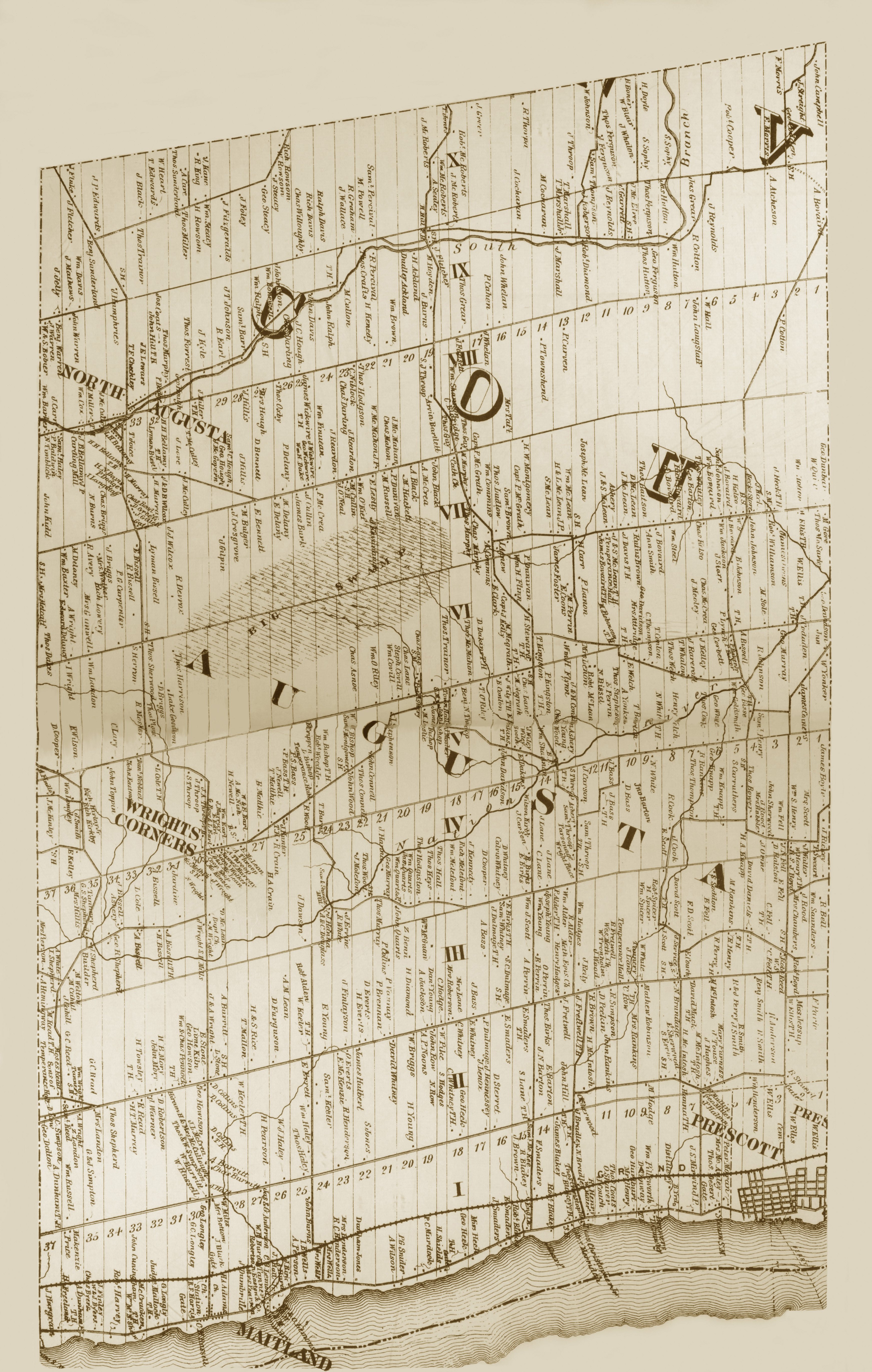
Dış bağlantılar
Augusta, Ontario'ya komşu yerler | |
|---|---|