Cooper County, Yeni Güney Galler - Cooper County, New South Wales - Wikipedia

Şunları kullanarak tüm koordinatları eşleyin: OpenStreetMap  
Koordinatları şu şekilde indirin: KML  · GPX
Cooper
Yeni Güney Galler
Cooper NSW.PNG
Arazi idari bölümleri Cooper çevresinde:
Dowling Dowling Gipps
Sturt Cooper Bourke
Boyd Mitchell Mitchell

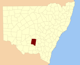
Cooper County 141 kişiden biri Yeni Güney Galler kadastro bölümleri. Kasabasını içerir Barellan. Murrumbidgee Nehri güney sınırıdır.

Cooper County, tüccar ve hayırsever Sir onuruna seçildi Daniel Cooper (1821-1902).[1]

Bu ilçedeki mahalleler

Cooper County NSW gösterildiği gibi John Sands 1886 haritası)[2]

Bu ilçede bulunan mahallelerin tam listesi; onların akımı LGA ve her bir konumun yaklaşık merkezine eşleme koordinatları aşağıdaki gibidir:

BucakLGAKoordinatlar
AriahBland Shire Konseyi34 ° 03′54 ″ G 146 ° 42′04 ″ D / 34.06500 ° G 146.70111 ° D / -34.06500; 146.70111 (Ariah)
BarellanNarrandera Shire Konseyi34 ° 13′54″ G 146 ° 29′04 ″ D / 34,23167 ° G 146,48444 ° D / -34.23167; 146.48444 (Barellan)
BarralongNarrandera Shire Konseyi34 ° 20′54″ G 146 ° 33′04 ″ D / 34.34833 ° G 146.55111 ° D / -34.34833; 146.55111 (Barralong)
BeremabereNarrandera Shire Konseyi34 ° 32′54″ G 146 ° 34'04 ″ D / 34,54833 ° G 146,56778 ° D / -34.54833; 146.56778 (Beremabere)
BingarCarrathool Shire Konseyi34 ° 07′54 ″ G 146 ° 12′04 ″ D / 34. 13167 ° G 146.20111 ° D / -34.13167; 146.20111 (Bingar)
BinyaCarrathool Shire Konseyi34 ° 12′54″ G 146 ° 18'04 ″ D / 34.21500 ° G 146.30111 ° D / -34.21500; 146.30111 (Binya)
BogolongNarrandera Shire Konseyi34 ° 39′54″ G 146 ° 43′04 ″ D / 34.66500 ° G 146.71778 ° D / -34.66500; 146.71778 (Bogolong)
BolaroNarrandera Shire Konseyi34 ° 27′54 ″ G 146 ° 44′04 ″ D / 34.46500 ° G 146.73444 ° D / -34.46500; 146.73444 (Bolaro)
BondiLeeton Shire Konseyi34 ° 21′54″ G 146 ° 16'04 ″ D / 34.36500 ° G 146.26778 ° D / -34.36500; 146.26778 (Bondi)
BourkeBland Shire Konseyi33 ° 56′54 ″ G 146 ° 24′04 ″ D / 33.94833 ° G 146.40111 ° D / -33.94833; 146.40111 (Bourke)
BourkeCarrathool Shire Konseyi33 ° 56′54 ″ G 146 ° 25′04 ″ D / 33.94833 ° G 146.41778 ° D / -33.94833; 146.41778 (Bourke)
BringanCarrathool Shire Konseyi34 ° 27′54 ″ G 146 ° 09′04 ″ E / 34,46500 ° G 146,15111 ° D / -34.46500; 146.15111 (Bringan)
BrobenahNarrandera Shire Konseyi34 ° 26′54 ″ G 146 ° 28′04 ″ D / 34.44833 ° G 146.46778 ° D / -34.44833; 146.46778 (Brobenah)
BundidgerryNarrandera Shire Konseyi34 ° 43′54″ G 146 ° 38′04 ″ D / 34,73167 ° G 146,63444 ° D / -34.73167; 146.63444 (Bundidgerry)
BunganbilNarrandera Shire Konseyi34 ° 26′54 ″ G 146 ° 37′04 ″ D / 34.44833 ° G 146.61778 ° D / -34.44833; 146.61778 (Bunganbil)
BygooBland Shire Konseyi34 ° 07′54 ″ G 146 ° 48′04 ″ D / 34.13167 ° G 146.80111 ° D / -34.13167; 146.80111 (Bygoo)
CamarookaCarrathool Shire Konseyi34 ° 23′54″ G 146 ° 02′04 ″ D / 34.39833 ° G 146.03444 ° D / -34.39833; 146.03444 (Camarooka)
CocoparraCarrathool Shire Konseyi33 ° 46′54″ G 146 ° 09′04 ″ E / 33.78167 ° G 146.15111 ° D / -33.78167; 146.15111 (Cocoparra)
ColaragangCarrathool Shire Konseyi34 ° 31′54″ G 146 ° 00′04 ″ D / 34,53167 ° G 146,00111 ° D / -34.53167; 146.00111 (Colaragang)
ColchesterCarrathool Shire Konseyi34 ° 23′54″ G 146 ° 09′04 ″ E / 34.39833 ° G 146.15111 ° D / -34.39833; 146.15111 (Colchester)
ConapairaCarrathool Shire Konseyi33 ° 50′54″ G 146 ° 16'04 ″ D / 33.84833 ° G 146.26778 ° D / -33.84833; 146.26778 (Conapaira)
Conapaira DoğuBland Shire Konseyi33 ° 49′54″ G 146 ° 23′04 ″ D / 33.83167 ° G 146.38444 ° D / -33.83167; 146.38444 (Conapaira Doğu)
Conapaira GüneyCarrathool Shire Konseyi33 ° 55′54″ G 146 ° 17′04 ″ D / 33,93167 ° G 146,28444 ° D / -33.93167; 146.28444 (Conapaira Güney)
KübaCarrathool Shire Konseyi34 ° 32′54″ G 146 ° 05′04 ″ D / 34,54833 ° G 146,08444 ° D / -34.54833; 146.08444 (Küba)
CudgelLeeton Shire Konseyi34 ° 37′54″ G 146 ° 29′04 ″ D / 34.63167 ° G 146.48444 ° D / -34.63167; 146.48444 (Cudgel)
CudjelloNarrandera Shire Konseyi34 ° 37′54″ G 146 ° 34'04 ″ D / 34.63167 ° G 146.56778 ° D / -34.63167; 146.56778 (Cudjello)
DallasCarrathool Shire Konseyi34 ° 35′54″ G 146 ° 14'04 ″ D / 34,59833 ° G 146,23444 ° D / -34.59833; 146.23444 (Dallas)
DowlingBland Shire Konseyi34 ° 05′54 ″ G 146 ° 36′04 ″ D / 34.09833 ° G 146.60111 ° D / -34.09833; 146.60111 (Dowling)
EdonLeeton Shire Konseyi34 ° 26′54 ″ G 146 ° 22′04 ″ D / 34.44833 ° G 146.36778 ° D / -34.44833; 146.36778 (Edon)
EurathaBland Shire Konseyi33 ° 46′54″ G 146 ° 32′04 ″ D / 33.78167 ° G 146.53444 ° D / -33.78167; 146.53444 (Euratha)
Euratha GüneyBland Shire Konseyi33 ° 52′54″ G 146 ° 31′04 ″ D / 33.88167 ° G 146.51778 ° D / -33.88167; 146.51778 (Euratha Güney)
GaroolganNarrandera Shire Konseyi34 ° 10′54″ G 146 ° 33′04 ″ D / 34,18167 ° G 146,55111 ° D / -34.18167; 146.55111 (Garoolgan)
GibbsNarrandera Shire Konseyi34 ° 21′54″ G 146 ° 22′04 ″ D / 34.36500 ° G 146.36778 ° D / -34.36500; 146.36778 (Gibbs)
GogeldrieLeeton Shire Konseyi34 ° 36′54″ G 146 ° 20′04 ″ D / 34.61500 ° G 146.33444 ° D / -34.61500; 146.33444 (Gogeldrie)
GortonCarrathool Shire Konseyi34 ° 20′54″ G 146 ° 10′04 ″ D / 34.34833 ° G 146.16778 ° D / -34.34833; 146.16778 (Gorton)
Grong GrongNarrandera Shire Konseyi34 ° 45′54″ G 146 ° 42′04 ″ D / 34.76500 ° G 146.70111 ° D / -34.76500; 146.70111 (Grong Grong)
GurragongBland Shire Konseyi33 ° 54′54″ G 146 ° 38′04 ″ D / 33.91500 ° G 146.63444 ° D / -33.91500; 146.63444 (Gurragong)
HebdenLeeton Shire Konseyi34 ° 25′54″ G 146 ° 15'04 ″ D / 34,43167 ° G 146,25111 ° D / -34.43167; 146.25111 (Hebden)
HulongCarrathool Shire Konseyi34 ° 34′54″ G 146 ° 08′04 ″ D / 34,58167 ° G 146,13444 ° D / -34.58167; 146.13444 (Hulong)
JondaryanGriffith Şehri34 ° 18′54″ G 146 ° 04′04 ″ D / 34.31500 ° G 146.06778 ° D / -34.31500; 146.06778 (Jondaryan)
KolkilbertooBland Shire Konseyi33 ° 58′54 ″ G 146 ° 32′04 ″ D / 33.98167 ° G 146.53444 ° D / -33.98167; 146.53444 (Kolkilbertoo)
Kolkilbertoo DoğuBland Shire Konseyi33 ° 59′54 ″ G 146 ° 36′04 ″ D / 33,99833 ° G 146,60111 ° D / -33.99833; 146.60111 (Kolkilbertoo Doğu)
Kolkilbertoo GüneyBland Shire Konseyi34 ° 05′54 ″ G 146 ° 30′04 ″ D / 34.09833 ° G 146.50111 ° D / -34.09833; 146.50111 (Kolkilbertoo Güney)
LewesBland Shire Konseyi33 ° 58′54 ″ G 146 ° 43′04 ″ D / 33.98167 ° G 146.71778 ° D / -33.98167; 146.71778 (Lewes)
MejumNarrandera Shire Konseyi34 ° 38′54″ G 146 ° 39′04 ″ D / 34.64833 ° G 146.65111 ° D / -34.64833; 146.65111 (Mejum)
MoombooldoolNarrandera Shire Konseyi34 ° 21′54″ G 146 ° 40'04 ″ D / 34.36500 ° G 146.66778 ° D / -34.36500; 146.66778 (Moombooldool)
Moombooldool KuzeyNarrandera Shire Konseyi34 ° 16′54″ G 146 ° 40'04 ″ D / 34.28167 ° G 146.66778 ° D / -34.28167; 146.66778 (Moombooldool Kuzey)
MouraNarrandera Shire Konseyi34 ° 17′54″ G 146 ° 23′04 ″ D / 34.29833 ° G 146.38444 ° D / -34.29833; 146.38444 (Moura)
MunduburraBland Shire Konseyi33 ° 49′54″ G 146 ° 38′04 ″ D / 33,83167 ° G 146,63444 ° D / -33.83167; 146.63444 (Munduburra)
MunduburraBland Shire Konseyi33 ° 50′54″ G 146 ° 38′04 ″ D / 33.84833 ° G 146.63444 ° D / -33.84833; 146.63444 (Munduburra)
NarranderaNarrandera Shire Konseyi34 ° 42′54″ G 146 ° 33′04 ″ D / 34.71500 ° G 146.55111 ° D / -34.71500; 146.55111 (Narrandera)
NarriahBland Shire Konseyi33 ° 51′54 ″ G 146 ° 44′04 ″ D / 33.86500 ° G 146.73444 ° D / -33.86500; 146.73444 (Narriah)
NarriahBland Shire Konseyi33 ° 50′54″ G 146 ° 44′04 ″ D / 33.84833 ° G 146.73444 ° D / -33.84833; 146.73444 (Narriah)
NauntonCarrathool Shire Konseyi34 ° 27′54 ″ G 146 ° 06′04 ″ D / 34.46500 ° G 146.10111 ° D / -34.46500; 146.10111 (Naunton)
Kuzey BolaroNarrandera Shire Konseyi34 ° 21′54″ G 146 ° 45'04 ″ D / 34.36500 ° G 146.75111 ° D / -34.36500; 146.75111 (Kuzey Bolaro)
OxleyNarrandera Shire Konseyi34 ° 07′54 ″ G 146 ° 24′04 ″ D / 34.13167 ° G 146.40111 ° D / -34.13167; 146.40111 (Oxley)
PattersonNarrandera Shire Konseyi34 ° 12′54″ G 146 ° 24′04 ″ D / 34.21500 ° G 146.40111 ° D / -34.21500; 146.40111 (Patterson)
PulletopCarrathool Shire Konseyi33 ° 56′54 ″ G 146 ° 08′04 ″ D / 33.94833 ° G 146.13444 ° D / -33.94833; 146.13444 (Pulletop)
Sandy CreekBland Shire Konseyi34 ° 09′54 ″ G 146 ° 41′04 ″ D / 34.16500 ° G 146.68444 ° D / -34.16500; 146.68444 (Sandy Creek)
Sims GapCarrathool Shire Konseyi33 ° 51′54 ″ G 146 ° 08′04 ″ D / 33,86500 ° G 146,13444 ° D / -33.86500; 146.13444 (Sims Gap)
StanbridgeGriffith Şehri34 ° 15′54″ G 146 ° 11'04 ″ D / 34.26500 ° G 146.18444 ° D / -34.26500; 146.18444 (Stanbridge)
StanleyCarrathool Shire Konseyi34 ° 06′54″ G 146 ° 18'04 ″ D / 34.11500 ° G 146.30111 ° D / -34.11500; 146.30111 (Stanley)
TabbitaCarrathool Shire Konseyi34 ° 06′54″ G 146 ° 06′04 ″ D / 34.11500 ° G 146.10111 ° D / -34.11500; 146.10111 (Tabbita)
Tabbita KuzeyCarrathool Shire Konseyi34 ° 01′54 ″ G 146 ° 08′04 ″ D / 34.03167 ° G 146.13444 ° D / -34.03167; 146.13444 (Tabbita Kuzey)
TenningerieLeeton Shire Konseyi34 ° 29′54″ G 146 ° 15'04 ″ D / 34.49833 ° G 146.25111 ° D / -34.49833; 146.25111 (Tenningerie)
BlöfCarrathool Shire Konseyi34 ° 01′54 ″ G 146 ° 16'04 ″ D / 34.03167 ° G 146.26778 ° D / -34.03167; 146.26778 (Blöf)
ZirveCarrathool Shire Konseyi34 ° 02′54 ″ G 146 ° 25′04 ″ D / 34.04833 ° G 146.41778 ° D / -34.04833; 146.41778 (Zirve)
TuckerbilLeeton Shire Konseyi34 ° 30′54″ G 146 ° 20′04 ″ D / 34.51500 ° G 146.33444 ° D / -34.51500; 146.33444 (Tuckerbil)
WallandryBland Shire Konseyi34 ° 00′54 ″ G 146 ° 48′04 ″ D / 34.01500 ° G 146.80111 ° D / -34.01500; 146.80111 (Wallandry)
Wallandry NorthBland Shire Konseyi33 ° 54′54″ G 146 ° 50′04 ″ D / 33.91500 ° G 146.83444 ° D / -33.91500; 146.83444 (Wallandry North)
WammeraNarrandera Shire Konseyi34 ° 33′54″ G 146 ° 40'04 ″ D / 34.56500 ° G 146.66778 ° D / -34.56500; 146.66778 (Wammera)
WattiNarrandera Shire Konseyi34 ° 34′54″ G 146 ° 44′04 ″ D / 34,58167 ° G 146,73444 ° D / -34.58167; 146.73444 (Watti)
WaughNarrandera Shire Konseyi34 ° 20′54″ G 146 ° 29′04 ″ D / 34.34833 ° G 146.48444 ° D / -34.34833; 146.48444 (Waugh)
WillbriggieCarrathool Shire Konseyi34 ° 27′54 ″ G 146 ° 01′04 ″ D / 34.46500 ° G 146.01778 ° D / -34.46500; 146.01778 (Willbriggie)
WillimbongLeeton Shire Konseyi34 ° 32′54″ G 146 ° 28′04 ″ D / 34.54833 ° G 146.46778 ° D / -34.54833; 146.46778 (Willimbong)
WyanganGriffith Şehri34 ° 12′54″ G 146 ° 05′04 ″ D / 34.21500 ° G 146.08444 ° D / -34.21500; 146.08444 (Wyangan)
YalgogoringBland Shire Konseyi34 ° 14′54″ G 146 ° 47′04 ″ D / 34.24833 ° G 146.78444 ° D / -34.24833; 146.78444 (Yalgogoring)
YarangeryLeeton Shire Konseyi34 ° 36′54″ G 146 ° 25′04 ″ D / 34.61500 ° G 146.41778 ° D / -34.61500; 146.41778 (Yarangery)
YendaGriffith Şehri34 ° 17′54″ G 146 ° 17′04 ″ D / 34.29833 ° G 146.28444 ° D / -34.29833; 146.28444 (Yenda)

Referanslar

  1. ^ "Cooper İlçesi". NSW Coğrafi Adlar Kaydı (GNR). Yeni Güney Galler Coğrafi İsimler Kurulu. Bunu Vikiveri'de düzenleyin
  2. ^ Avustralya'nın Yeni atlası (John Sands 1886) harita 21.