| İsim | yer | Listelendiği Tarih | Izgara Ref. [not 1] | Coğrafi koordinatlar | Notlar | LB Numarası [not 2] | Resim |
|---|
| Cardross Road, Notre Dame Roma Katolik Şapeli ve Manastırı | | | | 55 ° 56′45″ K 4 ° 35′37″ B / 55.945923 ° K 4.593621 ° B / 55.945923; -4.593621 (Cardross Road, Notre Dame Roma Katolik Şapeli ve Manastırı) | Kategori B | 24870 |  |
| Kilise Caddesi, Adliye | | | | 55 ° 56′40″ K 4 ° 33′59″ B / 55.944515 ° K 4.566443 ° B / 55.944515; -4.566443 (Kilise Caddesi, Adliye) | Kategori B | 24875 | |
| Dumbarton Kalesi | | | | 55 ° 56′12 ″ K 4 ° 33′48″ B / 55.936708 ° K 4.563252 ° B / 55.936708; -4.563252 (Dumbarton Kalesi) | A Kategorisi | 24880 | 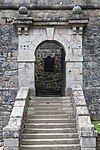 Başka bir resim yükle
|
| Levengrove Park Lodge ve Gatepiers | | | | 55 ° 56′33″ K 4 ° 34′38″ B / 55.942375 ° K 4.577272 ° B / 55.942375; -4.577272 (Levengrove Park Lodge ve Gatepiers) | Kategori B | 24904 | |
| Stirling Yolu'ndaki West Lodge'da Overtoun Gatepiers | | | | 55 ° 56′53 ″ K 4 ° 32′52″ B / 55.948057 ° K 4.547808 ° B / 55.948057; -4.547808 (Stirling Yolu'ndaki West Lodge'da Overtoun Gatepiers) | Kategori B | 24911 |  Başka bir resim yükle
|
| Stirling Road Dumbarton Mezarlığı, Duvar Kapıları ve Ağ Geçitleri | | | | 55 ° 57′07 ″ K 4 ° 33′00 ″ B / 55.95187 ° K 4.549885 ° B / 55.95187; -4.549885 (Stirling Road Dumbarton Mezarlığı, Duvar Kapıları ve Ağ Geçitleri) | Kategori B | 24913 |  Başka bir resim yükle
Daha fazla görsele bakın |
| West Bridgend, West Kirk Hall ve Gatepiers | | | | 55 ° 56′44″ K 4 ° 34′45″ B / 55.945615 ° K 4.579185 ° B / 55.945615; -4.579185 (West Bridgend, West Kirk Hall ve Gatepiers) | Kategori B | 24919 | |
| Vale Of Leven Sanayi Sitesine Giriş | | | | 55 ° 58′07 ″ K 4 ° 34′22″ B / 55.968688 ° K 4.572723 ° B / 55.968688; -4.572723 (Vale Of Leven Sanayi Sitesine Giriş) | Kategori B | 824 | |
| 125-9 (Tek Sayılar) Kolej Caddesi / 1, 2 İstasyon Yolu | | | | 55 ° 56′46″ K 4 ° 34′08″ B / 55.946109 ° K 4.568887 ° B / 55.946109; -4.568887 (125-9 (Tek Sayılar) Kolej Caddesi / 1, 2 İstasyon Yolu) | Kategori C (S) | 24878 | |
| 17-21 (Tek Sayılar) Ana Cadde | | | | 55 ° 56′35″ K 4 ° 34′09 ″ B / 55,94296 ° K 4,569046 ° B / 55.94296; -4.569046 (17-21 (Tek Sayılar) Ana Cadde) | Kategori B | 24886 | |
| 127-135 (Tek Sayılar) Ana Cadde | | | | 55 ° 56′37″ K 4 ° 34′20″ B / 55.943601 ° K 4.57234 ° B / 55.943601; -4.57234 (127-135 (Tek Sayılar) Ana Cadde) | Kategori B | 24888 | |
| Kirktonhill 15 Dixon Drive, Shamrockbank | | | | 55 ° 56′25″ K 4 ° 34′53 ″ B / 55.940412 ° K 4.581273 ° B / 55.940412; -4.581273 (Kirktonhill 15 Dixon Drive, Shamrockbank) | Kategori C (S) | 24891 | |
| Kirktonhill 38 Helenslee Yolu Methlan Park Evi | | | | 55 ° 56′23″ K 4 ° 34′48″ B / 55.939629 ° K 4.580036 ° B / 55.939629; -4.580036 (Kirktonhill 38 Helenslee Yolu Methlan Park Evi) | Kategori B | 24901 | |
| Levengrove Park Savaş Anıtı | | | | 55 ° 56′18″ K 4 ° 34′31″ B / 55.938202 ° K 4.575233 ° B / 55.938202; -4.575233 (Levengrove Park Savaş Anıtı) | Kategori C (S) | 24905 | |
| Maclean Place Bitişik Duvarları, Pencereleri ve Oyma Taşı İçeren Eski Hapishane Geçidi | | | | 55 ° 56′40″ K 4 ° 33′58″ B / 55.944547 ° K 4.56622 ° B / 55.944547; -4.56622 (Maclean Place Bitişik Duvarları, Pencereleri ve Oyma Taşı İçeren Eski Hapishane Geçidi) | Kategori B | 24906 | 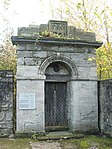 Başka bir resim yükle
Daha fazla görsele bakın |
| South Drive'da Overtoun House Gatepiers | | | | 55 ° 56′52″ K 4 ° 31′27″ B / 55.9477 ° K 4.524094 ° B / 55.9477; -4.524094 (South Drive'da Overtoun House Gatepiers) | Kategori C (S) | 24909 | |
| 2 Cardross Road, St Michael's Roma Katolik Kilisesi | | | | 55 ° 56′54 ″ K 4 ° 34′59″ B / 55.948444 ° K 4.583169 ° B / 55.948444; -4.583169 (2 Cardross Road, St Michael's Roma Katolik Kilisesi) | Kategori B | 24871 | |
| Castle Street, Napier Mozolesi (Riverside Parish Kilisesi Arkası) | | | | 55 ° 56′35″ K 4 ° 34′00 ″ B / 55,942956 ° K 4,56666 ° B / 55.942956; -4.56666 (Castle Street, Napier Mozolesi (Riverside Parish Kilisesi Arkası)) | Kategori C (S) | 24872 | |
| Castle Street, Gemi Modeli Deney Tankı (British Shipbuilders - Eskiden Vickers Ltd) | | | | 55 ° 56′36″ K 4 ° 33′46″ B / 55.943205 ° K 4.562896 ° B / 55.943205; -4.562896 (Castle Street, Gemi Modeli Deney Tankı (British Shipbuilders - Eskiden Vickers Ltd)) | A Kategorisi | 24873 | |
| Church Street, Sseb Education Offices (Eski Akademi) | | | | 55 ° 56′38″ K 4 ° 34′01 ″ B / 55.943865 ° K 4.567024 ° B / 55.943865; -4.567024 (Church Street, Sseb Education Offices (Eski Akademi)) | A Kategorisi | 24874 |  Başka bir resim yükle
|
| Overtoun Terrace 205-209 (Odd Nos) Glasgow Yolu | | | | 55 ° 56′29 ″ K 4 ° 33′02 ″ B / 55.941508 ° K 4.550677 ° B / 55.941508; -4.550677 (Overtoun Terrace 205-209 (Odd Nos) Glasgow Yolu) | Kategori C (S) | 24884 | |
| High Street St Augustine Piskoposluk Kilisesi | | | | 55 ° 56′37″ K 4 ° 34′06 ″ B / 55.943678 ° K 4.568245 ° B / 55.943678; -4.568245 (High Street St Augustine Piskoposluk Kilisesi) | A Kategorisi | 24890 |  Başka bir resim yükle
Daha fazla görsele bakın |
| Kirktonhill, 10, 12 Dixon Drive | | | | 55 ° 56′28″ K 4 ° 34′47″ B / 55.940986 ° K 4.57963 ° B / 55.940986; -4.57963 (Kirktonhill, 10, 12 Dixon Drive) | Kategori B | 24894 | |
| Overtoun Ev Ve Bahçe Duvarları | | | | 55 ° 57′08″ K 4 ° 31′29 ″ B / 55.952263 ° K 4.524696 ° B / 55.952263; -4.524696 (Overtoun Ev Ve Bahçe Duvarları) | A Kategorisi | 24907 | |
| Coach House Range ve Stable Yard, Strathleven | | | | 55 ° 58′09 ″ K 4 ° 34′09 ″ B / 55.969258 ° K 4.569091 ° B / 55.969258; -4.569091 (Coach House Range ve Stable Yard, Strathleven) | Kategori B | 822 | |
| King's Way, Dalreoch İlköğretim Okulu | | | | 55 ° 57′10″ K 4 ° 35′19″ B / 55.952826 ° K 4.588508 ° B / 55.952826; -4.588508 (King's Way, Dalreoch İlköğretim Okulu) | Kategori B | 50122 | |
| Bonhill Yolu, Westonlee Evi ve Gatepiers | | | | 55 ° 56′56″ K 4 ° 33′41″ B / 55.948776 ° K 4.561262 ° B / 55.948776; -4.561262 (Bonhill Yolu, Westonlee Evi ve Gatepiers) | Kategori B | 24868 | |
| 20, 22 Cardross Yolu, Braehead Evleri | | | | 55 ° 56′51″ K 4 ° 35′06 ″ B / 55.947562 ° K 4.584953 ° B / 55.947562; -4.584953 (20, 22 Cardross Yolu, Braehead Evleri) | Kategori B | 24869 | |
| Glasgow Yolu, Peter Denny Heykeli, (Belediye Binalarında) | | | | 55 ° 56′44″ K 4 ° 34-03 ″ B / 55.945686 ° K 4.567625 ° B / 55.945686; -4.567625 (Glasgow Yolu, Peter Denny Heykeli, (Belediye Binalarında)) | Kategori B | 24882 | |
| High Street, The Bell Leisure Centre (Eski Yüksek Kilise) | | | | 55 ° 56′38″ K 4 ° 34′24″ B / 55.943884 ° K 4.573448 ° B / 55.943884; -4.573448 (High Street, The Bell Leisure Centre (Eski Yüksek Kilise)) | Kategori B | 24889 | |
| Kirktonhill 2, 4 Dixon Drive ve Gatepiers | | | | 55 ° 56′27″ K 4 ° 34′41″ B / 55.940882 ° K 4.578149 ° B / 55.940882; -4.578149 (Kirktonhill 2, 4 Dixon Drive ve Gatepiers) | Kategori C (S) | 24892 | |
| Kirktonhill, Helenslee Yolu Yol Köprüsü | | | | 55 ° 56′36″ K 4 ° 34′42″ B / 55.943469 ° K 4.578241 ° B / 55.943469; -4.578241 (Kirktonhill, Helenslee Yolu Yol Köprüsü) | Kategori C (S) | 24895 | |
| Kirktonhill, Helenslee Yolu Garmoyle Carmelite Manastırı ve Bahçe Duvarları | | | | 55 ° 56′29 ″ K 4 ° 34′54″ B / 55.941347 ° K 4.581688 ° B / 55.941347; -4.581688 (Kirktonhill, Helenslee Yolu Garmoyle Carmelite Manastırı ve Bahçe Duvarları) | Kategori B | 24900 | |
| Overtoun House, Garshake Drive'daki Bridge Overtoun Burn | | | | 55 ° 57′10″ K 4 ° 31′31″ B / 55.952648 ° K 4.525217 ° B / 55.952648; -4.525217 (Overtoun House, Garshake Drive'daki Bridge Overtoun Burn) | Kategori B | 24908 |  Başka bir resim yükle
Daha fazla görsele bakın |
| 16 Round Riding Road, Greenfield | | | | 55 ° 56′55″ K 4 ° 33′30″ B / 55.948512 ° K 4.558394 ° B / 55.948512; -4.558394 (16 Round Riding Road, Greenfield) | Kategori C (S) | 24912 | |
| Church Street, College Bow (St Mary's Collegiate Kilisesi'nin Eski Kule Kemeri) | | | | 55 ° 56′45″ K 4 ° 34′01 ″ B / 55.94586 ° K 4.56706 ° B / 55.94586; -4.56706 (Church Street, College Bow (St Mary's Collegiate Kilisesi'nin Eski Kule Kemeri)) | Kategori B | 24876 |  Başka bir resim yükle
Daha fazla görsele bakın |
| Church Street, Dumbarton Merkez İstasyonu | | | | 55 ° 56′48″ K 4 ° 34-03 ″ B / 55.946648 ° K 4.567593 ° B / 55.946648; -4.567593 (Church Street, Dumbarton Merkez İstasyonu) | A Kategorisi | 24877 | |
| Dumbarton Köprüsü (Leven Nehri Üzerinde) | | | | 55 ° 56′39 ″ K 4 ° 34′31″ B / 55.944304 ° K 4.575286 ° B / 55.944304; -4.575286 (Dumbarton Köprüsü (Leven Nehri Üzerinde)) | Kategori B | 24879 |  Başka bir resim yükle
|
| Kirktonhill Helenslee Road Keil School Lodge ve Gatepiers | | | | 55 ° 56′35″ K 4 ° 34′57″ B / 55.943058 ° K 4.58241 ° B / 55.943058; -4.58241 (Kirktonhill Helenslee Road Keil School Lodge ve Gatepiers) | Kategori B | 24898 | |
| 38 Helenslee Yolu Methlan Park House Lodge Ve Gatepiers | | | | 55 ° 56′23″ K 4 ° 34′42″ B / 55.939718 ° K 4.578376 ° B / 55.939718; -4.578376 (38 Helenslee Yolu Methlan Park House Lodge Ve Gatepiers) | Kategori C (S) | 24902 | |
| Stirling Yolunda Overtoun West Lodge | | | | 55 ° 56′53 ″ K 4 ° 32′52″ B / 55.947952 ° K 4.547657 ° B / 55.947952; -4.547657 (Stirling Yolunda Overtoun West Lodge) | Kategori B | 24910 | |
| West Bridgend, Levenford House Bahçe Duvarları ve Geçidi | | | | 55 ° 56′42″ K 4 ° 34′43″ B / 55.944929 ° K 4.578482 ° B / 55.944929; -4.578482 (West Bridgend, Levenford House Bahçe Duvarları ve Geçidi) | Kategori B | 24917 | |
| West Bridgend, Levenford House Lodge ve Eski Ahırlar (Helenslee Yolu Üzerinde) | | | | 55 ° 56′37″ K 4 ° 34′41″ B / 55.943571 ° K 4.578104 ° B / 55.943571; -4.578104 (West Bridgend, Levenford House Lodge ve Eski Ahırlar (Helenslee Yolu Üzerinde)) | Kategori B | 24918 | |
| Strathleven Evi | | | | 55 ° 58′09 ″ K 4 ° 34′17 ″ B / 55.96919 ° K 4.571491 ° B / 55.96919; -4.571491 (Strathleven Evi) | A Kategorisi | 115 | 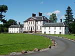 Başka bir resim yükle
|
| Glasgow Road Belediye Binaları ve Gatepiers | | | | 55 ° 56′46″ K 4 ° 34′02 ″ B / 55.946016 ° K 4.567295 ° B / 55.946016; -4.567295 (Glasgow Road Belediye Binaları ve Gatepiers) | Kategori B | 24881 | |
| High Street, Dumbarton Riverside Parish Church, Mezarlık Duvarları ve Geçitleri | | | | 55 ° 56′35″ K 4 ° 34′02 ″ B / 55.942927 ° K 4.56717 ° B / 55.942927; -4.56717 (High Street, Dumbarton Riverside Parish Church, Mezarlık Duvarları ve Geçitleri) | A Kategorisi | 24885 |  Başka bir resim yükle
|
| High Street, Glencairn Tenement (Gas Board Ofisleri) | | | | 55 ° 56′35″ K 4 ° 34′17 ″ B / 55.943147 ° K 4.571301 ° B / 55.943147; -4.571301 (High Street, Glencairn Tenement (Gas Board Ofisleri)) | Kategori B | 24887 |  Başka bir resim yükle
|
| Kirktonhill 6, 8 Dixon Drive | | | | 55 ° 56′27″ K 4 ° 34′44″ B / 55.940921 ° K 4.578857 ° B / 55.940921; -4.578857 (Kirktonhill 6, 8 Dixon Drive) | Kategori C (S) | 24893 | |
| West Bridgend, Levenford Evi | | | | 55 ° 56′41″ K 4 ° 34′45″ B / 55.944691 ° K 4.579107 ° B / 55.944691; -4.579107 (West Bridgend, Levenford Evi) | A Kategorisi | 24916 | 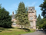 Başka bir resim yükle
|
| Kirktonhill Helenslee Road Keil Okulu (Eski adıyla Helenslee) | | | | 55 ° 56′29 ″ K 4 ° 35′06 ″ B / 55.941486 ° K 4.584916 ° B / 55.941486; -4.584916 (Kirktonhill Helenslee Road Keil Okulu (Eski adıyla Helenslee)) | Kategori B | 24896 | |
| Latta Caddesi, Hartfield Evi | | | | 55 ° 56′52″ K 4 ° 33′40″ B / 55.94782 ° K 4.560975 ° B / 55.94782; -4.560975 (Latta Caddesi, Hartfield Evi) | Kategori C (S) | 24903 | |
| Strathleven Place St Patrick's Rc Kilisesi, Kulesi ve Gatepiers | | | | 55 ° 56′44″ K 4 ° 33′51″ B / 55.945459 ° K 4.564263 ° B / 55.945459; -4.564263 (Strathleven Place St Patrick's Rc Kilisesi, Kulesi ve Gatepiers) | Kategori B | 24914 | |
| Strathleven Place Drumoyne | | | | 55 ° 56′44″ K 4 ° 33′49″ B / 55.945632 ° K 4.56373 ° B / 55.945632; -4.56373 (Strathleven Place Drumoyne) | Kategori B | 24915 | |
| Dovecot, Strathleven | | | | 55 ° 58′11 ″ K 4 ° 34′13 ″ B / 55.969683 ° K 4.570289 ° B / 55.969683; -4.570289 (Dovecot, Strathleven) | A Kategorisi | 823 |  Başka bir resim yükle
|
| Leven Caddesi, Sınır Duvarı ve Korkuluklar Dahil Birleşik Reform Kilisesi | | | | 55 ° 56′35″ K 4 ° 33′38″ B / 55.943013 ° K 4.560433 ° B / 55.943013; -4.560433 (Leven Street, Sınır Duvarı ve Korkuluklar Dahil Birleşik Reform Kilisesi) | Kategori C (S) | 50543 | |
| 67, 69 Glasgow Yolu | | | | 55 ° 56′37″ K 4 ° 33′34 ″ B / 55.943628 ° K 4.559417 ° B / 55.943628; -4.559417 (67, 69 Glasgow Yolu) | Kategori C (S) | 24883 | |
| Helenslee Road Keil School Technical Block (Eski adıyla Helenslee Stables) | | | | 55 ° 56′37″ K 4 ° 34′58″ B / 55.94351 ° K 4.582728 ° B / 55.94351; -4.582728 (Helenslee Road Keil School Technical Block (Eski adıyla Helenslee Stables)) | Kategori B | 24897 | |
| West Bridgend, West Kirk | | | | 55 ° 56′45″ K 4 ° 34′45″ B / 55.945793 ° K 4.579293 ° B / 55.945793; -4.579293 (West Bridgend, West Kirk) | Kategori B | 24920 | |


