Perry County, Yeni Güney Galler - Perry County, New South Wales

Tüm koordinatları kullanarak eşleyin: OpenStreetMap  
Koordinatları şu şekilde indirin: KML  · GPX
Perry
Yeni Güney Galler
Perry NSW.PNG
Arazi idari bölümleri Perry çevresinde:
Menindee Livingstone Manara
Windeyer Perry Manara
Wentworth Wentworth Kilfera

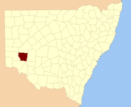
Perry County 141 kişiden biri Yeni Güney Galler kadastro bölümleri. Doğu'nun doğusunda yer almaktadır. Darling Nehri yakın Pooncarie.

Perry County onuruna seçildi Samuel Augustus Perry (1792–1854), asker ve araştırmacı.[1]

Bu ilçedeki mahalleler

Bu ilçede bulunan mahallelerin tam listesi; onların akımı LGA ve her bir konumun yaklaşık merkezine eşleme koordinatları aşağıdaki gibidir:

BucakLGAKoordinatlar
AstolatCentral Darling Shire32 ° 50′25″ G 142 ° 45′54 ″ D / 32,84028 ° G 142,76500 ° D / -32.84028; 142.76500 (Astolat)
BarraraWentworth Shire33 ° 06′55″ G 142 ° 21′41″ D / 33.11528 ° G 142.36139 ° D / -33.11528; 142.36139 (Barrara)
BarrittWentworth Shire32 ° 57′37 ″ G 142 ° 27′15 ″ D / 32.96028 ° G 142.45417 ° D / -32.96028; 142.45417 (Barritt)
BeelaWentworth Shire33 ° 19′27″ G 143 ° 14′44 ″ D / 33.32417 ° G 143.24556 ° D / -33.32417; 143.24556 (Beela)
ÇanWentworth Shire33 ° 28′58″ G 142 ° 42′15 ″ D / 33.48278 ° G 142.70417 ° D / -33.48278; 142.70417 (Çan)
BertramWentworth Shire33 ° 25′44″ G 143 ° 09′07 ″ E / 33,42889 ° G 143,15194 ° D / -33.42889; 143.15194 (Bertram)
BimpiaWentworth Shire32 ° 56′49″ G 142 ° 59′21″ D / 32.94694 ° G 142.98917 ° D / -32.94694; 142.98917 (Bimpia)
BlenalbenWentworth Shire32 ° 55′41″ G 143 ° 16′39 ″ D / 32.92806 ° G 143.27750 ° D / -32.92806; 143.27750 (Blenalben)
BurkeWentworth Shire33 ° 05′17 ″ G 142 ° 44′22″ D / 33.08806 ° G 142.73944 ° D / -33.08806; 142.73944 (Burke)
CamelotWentworth Shire33 ° 00-35″ G 143 ° 05′11 ″ D / 33.00972 ° G 143.08639 ° D / -33.00972; 143.08639 (Camelot)
CoonongWentworth Shire33 ° 00′12 ″ G 143 ° 10-53 ″ D / 33.00333 ° G 143.18139 ° D / -33.00333; 143.18139 (Coonong)
CooyarundaWentworth Shire32 ° 54′47″ G 142 ° 51′50 ″ D / 32.91306 ° G 142.86389 ° D / -32.91306; 142.86389 (Cooyarunda)
DarchyWentworth Shire33 ° 20′54″ G 142 ° 36′45″ D / 33.34833 ° G 142.61250 ° D / -33.34833; 142.61250 (Darchy)
EnidWentworth Shire33 ° 03′42″ G 142 ° 58′23 ″ D / 33.06167 ° G 142.97306 ° D / -33.06167; 142.97306 (Enid)
EuchlaWentworth Shire33 ° 20′44″ G 142 ° 43′33″ D / 33.34556 ° G 142.72583 ° D / -33.34556; 142.72583 (Euchla)
GarnpungWentworth Shire33 ° 32′15 ″ G 143 ° 08′07 ″ D / 33.53750 ° G 143.13528 ° D / -33.53750; 143.13528 (Garnpung)
GlenstalWentworth Shire33 ° 03′52″ G 142 ° 22-56″ D / 33.06444 ° G 142.38222 ° D / -33.06444; 142.38222 (Glenstal)
GriWentworth Shire33 ° 07′24″ G 143 ° 04′14 ″ D / 33.12333 ° G 143.07056 ° D / -33.12333; 143.07056 (Gri)
GunpanoolaWentworth Shire32 ° 53′06 ″ G 142 ° 44′47″ D / 32.88500 ° G 142.74639 ° D / -32.88500; 142.74639 (Gunpanoola)
HarleyWentworth Shire33 ° 15-25 G 142 ° 37′09 ″ D / 33.25694 ° G 142.61917 ° D / -33.25694; 142.61917 (Harley)
HowittWentworth Shire33 ° 12′07 ″ G 142 ° 43′40″ D / 33. 20194 ° G 142.72778 ° E / -33.20194; 142.72778 (Howitt)
KandraWentworth Shire33 ° 11′43″ G 143 ° 17′34 ″ D / 33,19528 ° G 143,29278 ° D / -33.19528; 143.29278 (Kandra)
KarpakoraWentworth Shire32 ° 53′33″ G 143 ° 06′10 ″ D / 32.89250 ° G 143.10278 ° D / -32.89250; 143.10278 (Karpakora)
KralWentworth Shire33 ° 10′27″ G 142 ° 57′25 ″ D / 33.17417 ° G 142.95694 ° D / -33.17417; 142.95694 (Kral)
MapennyWentworth Shire33 ° 17′27″ G 142 ° 56′26″ D / 33.29083 ° G 142.94056 ° D / -33.29083; 142.94056 (Mapenny)
MidgehopeWentworth Shire33 ° 00′59 ″ G 143 ° 21′13 ″ D / 33.01639 ° G 143.35361 ° D / -33.01639; 143.35361 (Midgehope)
MitchellWentworth Shire33 ° 27′07 ″ G 142 ° 55′02 ″ D / 33.45194 ° G 142.91722 ° D / -33.45194; 142.91722 (Mitchell)
MooloolerieWentworth Shire33 ° 01′58″ G 142 ° 44′48″ D / 33.03278 ° G 142.74667 ° D / -33.03278; 142.74667 (Mooloolerie)
MooraraWentworth Shire33 ° 10′29″ G 142 ° 21′17 ″ D / 33,17472 ° G 142,35472 ° D / -33.17472; 142.35472 (Moorara)
MorthongWentworth Shire33 ° 11′48″ G 143 ° 09′46 ″ E / 33.19667 ° G 143.16278 ° D / -33.19667; 143.16278 (Morthong)
MuellerWentworth Shire33 ° 24′13 ″ G 142 ° 55′28″ D / 33.40361 ° G 142.92444 ° D / -33.40361; 142.92444 (Mueller)
MungoWentworth Shire33 ° 23′01 ″ G 142 ° 49′15 ″ D / 33.38361 ° G 142.82083 ° D / -33.38361; 142.82083 (Mungo)
MytheWentworth Shire33 ° 08′35″ G 142 ° 28′43 ″ D / 33.14306 ° G 142.47861 ° D / -33.14306; 142.47861 (Mythe)
NambucurraWentworth Shire33 ° 14′14″ G 143 ° 03′14 ″ E / 33,23722 ° G 143,05389 ° D / -33.23722; 143.05389 (Nambucurra)
NandaWentworth Shire33 ° 03′40″ G 142 ° 36′26″ D / 33.06111 ° G 142.60722 ° D / -33.06111; 142.60722 (Nanda)
NaniaWentworth Shire33 ° 21′13 ″ G 143 ° 02′12 ″ D / 33,35361 ° G 143,03667 ° D / -33.35361; 143.03667 (Nania)
NeliaWentworth Shire33 ° 11′08 ″ G 142 ° 32-35 ″ D / 33.18556 ° G 142.54306 ° D / -33.18556; 142.54306 (Nelia)
NuccaloWentworth Shire32 ° 49′15 ″ G 143 ° 12′31″ D / 32.82083 ° G 143.20861 ° D / -32.82083; 143.20861 (Nuccalo)
Pan YasağıWentworth Shire33 ° 16-52″ G 143 ° 08′58″ D / 33.28111 ° G 143.14944 ° D / -33.28111; 143.14944 (Pan Yasağı)
PepporaWentworth Shire32 ° 52′12 ″ G 142 ° 36′46″ D / 32.87000 ° G 142.61278 ° D / -32.87000; 142.61278 (Peppora)
PerryWentworth Shire33 ° 27′49 ″ G 143 ° 01′13 ″ D / 33.46361 ° G 143.02028 ° D / -33.46361; 143.02028 (Perry)
ÇamlarWentworth Shire32 ° 56-33″ G 142 ° 36′58″ D / 32.94250 ° G 142.61611 ° D / -32.94250; 142.61611 (Çamlar)
PombraWentworth Shire33 ° 08′34 ″ G 142 ° 36′00″ D / 33.14278 ° G 142.60000 ° D / -33.14278; 142.60000 (Pombra)
PooncairaWentworth Shire33 ° 28′06 ″ G 142 ° 35′39 ″ D / 33.46833 ° G 142.59417 ° D / -33.46833; 142.59417 (Pooncaira)
KirpiCentral Darling Shire32 ° 46′33″ G 142 ° 54′17 ″ D / 32.77583 ° G 142.90472 ° D / -32.77583; 142.90472 (Kirpi)
PrunellaCentral Darling Shire32 ° 44′41″ G 142 ° 35′31″ D / 32.74472 ° G 142.59194 ° D / -32.74472; 142.59194 (Prunella)
TarcoolaWentworth Shire33 ° 27′55″ G 142 ° 48′19 ″ D / 33,46528 ° G 142,80528 ° D / -33.46528; 142.80528 (Tarcoola)
TarmoolaWentworth Shire33 ° 03′07 ″ G 142 ° 51′56 ″ D / 33,05194 ° G 142,86556 ° D / -33.05194; 142.86556 (Tarmoola)
TartnaCentral Darling Shire32 ° 53′32″ G 142 ° 26′10 ″ D / 32.89222 ° G 142.43611 ° D / -32.89222; 142.43611 (Tartna)
TimpungaWentworth Shire33 ° 17-02 ″ G 142 ° 29′15 ″ D / 33.28389 ° G 142.48750 ° D / -33.28389; 142.48750 (Timpunga)
TolarnoCentral Darling Shire
TuckinyaWentworth Shire32 ° 46′45″ G 143 ° 04′00″ D / 32.77917 ° G 143.06667 ° D / -32.77917; 143.06667 (Tuckinya)
WanteboolkaWentworth Shire33 ° 05′01 ″ G 143 ° 15′15″ D / 33.08361 ° G 143.25417 ° D / -33.08361; 143.25417 (Wanteboolka)
GalceWentworth Shire33 ° 12′49″ G 142 ° 50′30″ D / 33.21361 ° G 142.84167 ° D / -33.21361; 142.84167 (Galce)
WentworthWentworth Shire33 ° 00′28″ G 142 ° 29′32″ D / 33.00778 ° G 142.49222 ° D / -33.00778; 142.49222 (Wentworth)
VasiyetnameWentworth Shire33 ° 06′03 ″ G 142 ° 51′30″ D / 33.10083 ° G 142.85833 ° D / -33.10083; 142.85833 (Vasiyetname)
WrefordWentworth Shire33 ° 12′37″ G 142 ° 26′18″ D / 33.21028 ° G 142.43833 ° D / -33.21028; 142.43833 (Wreford)
YendaCentral Darling Shire

Referanslar

  1. ^ "Perry". NSW Coğrafi Adlar Kaydı (GNR). Yeni Güney Galler Coğrafi İsimler Kurulu. Alındı 7 Ağustos 2013. Bunu Vikiveri'de düzenleyin