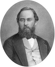
Ağustos Heinrich Petermann - August Heinrich Petermann
Bu makalenin birden çok sorunu var. Lütfen yardım et onu geliştir veya bu konuları konuşma sayfası. (Bu şablon mesajların nasıl ve ne zaman kaldırılacağını öğrenin) (Bu şablon mesajını nasıl ve ne zaman kaldıracağınızı öğrenin)
|
Ağustos Heinrich Petermann | |
|---|---|
 | |
| Doğum | 18 Nisan 1822 |
| Öldü | 25 Eylül 1878 (56 yaş) |
| Milliyet | Almanca |
| Bilinen | "Harita olmadan sorun yok"[1] |
| Bilimsel kariyer | |
| Alanlar | Haritacılık |
Augustus Heinrich Petermann (18 Nisan 1822 - 25 Eylül 1878) bir Alman haritacı.
İlk yıllar
Petermann doğdu Bleicherode, Almanya. 14 yaşındayken yakınlardaki kasabada gramer okuluna başladı. Nordhausen. Annesi onun bir din adamı olmasını istedi, ancak harita çizmedeki mükemmelliği ve coğrafi okumalara olan sevgisi, başka bir kariyer tercihini kaçınılmaz hale getirdi.
Heinrich Berghaus desteğiyle Alexander von Humboldt 'Geographische Kunstschule' (Geographica School of Art) 1839 yılında Potsdam, Paris'teki Militaires Generales Arşivlerindeki gravür okulu örneğini takip ederek (1811'den beri) Berlin'e yakın. Varlığı boyunca Berghaus'un akademisi sadece üç kurs sundu ve sadece birkaç öğrenci katıldı:
- 1839–1844: August Petermann, Heinrich 'Henry' Lange (1821–1893) ve bir yıl sonra tüberkülozdan ölen Otto Göcke
- 1844–1847: Amandus Sturmhöfel (1823–?) Ve Theodor Schilling
- 1845–1850: Hermann Berghaus (1828–1890), yeğeni
Petermann'ın babası, Bleicherode'de kayıt memuru olan August Rudolf Petermann, oğlunun ileri eğitimi için ödeme yapamadı. Berghaus'un okulunun ilanını okuduğunda oğlunun haritalarını ve diğer çalışmalarını değerlendirme için gönderir. 16 yaşında çizilen haritalardan biri Güney Amerika'yı gösteriyor ve daha sonra adını taşıyan dergide yayınlandı.[2] Berghaus, işinin kalitesini ve dolayısıyla potansiyelini fark etmiş ve kısa süre sonra onu bir evlat olarak kabul etmiş olmalı. Zaten beslenmesi gereken büyük bir ailesi olduğu için, yıllık 60 dolarlık bir sübvansiyon talep etti. thaler Kraldan Petermann'ı desteklemek için talepte bulundu. Üçüncü kurs sırasında Berghaus, yeğeni Hermann Berghaus'a da aynı şekilde davrandı. Sadece Lange kurslar için ödeme yaptı, geri kalanı masrafları Berghaus'un kendi hesabına olacak şekilde onları takip etti.
Petermann, 7 Ağustos 1839'da Potsdam'da başladı. Berghaus ile eğitime, matematiksel coğrafyayı içeren bilimsel kartografik denilebilir (harita projeksiyonu ve ızgaralar ), fiziksel coğrafya (meteoroloji, hidroloji ve jeoloji ) ve siyasi coğrafya (özellikle Avrupa devletlerinin sınırları ve idari bölümleri hakkında bilgi). Beden eğitimi daha çok araştırma, çizim ve kazıma amaçlıydı. Berghaus'un öğrencileri, kendisinin öğrendiğinden bile daha az, yalnızca anketin temellerini öğrendiler: bu alandaki çalışmaları Potsdam'ın planında görülebilir (Neüster Plan von der Königlichen Residenzstadt Potsdam / nach trigonometrischen Vermessungen, yani geo- und hydrometrischen Aufnahmen ausgearbeitet in der Geographischen Kunstschule zu Potsdam unter der Leitung ihres Direktörler, des Profesörler Dr. Heinrich Berghaus. 1845). Topografyacı değillerdi ve yalnızca o dönemin büyük ölçekli haritalarında yayınlandığı şekliyle topografyayı, daha sonraki, daha genelleştirilmiş çalışmaları için genel bir temel olarak kullandılar. Devletlerin, kıtaların vb. Orta ölçekli coğrafi haritalarını veya bunların parçalarını (örneğin, 1847'de üst ve orta İtalya haritası) hazırlamak ve kazımak için daha fazla şey öğretildi. Stielers Handatlas dayalı olan Attilio Zuccagni-Orlandini 'nin yaklaşık 100 sayfalık 1844 topografik haritası), küçük ölçekli genelleştirilmiş okul haritaları ve özellikle uygulamalı coğrafya ve haritacılık, Physikalischer Atlas ve denizcilik atlası. Çalışmaları sırasında litografi kadar iyi bir tasviri kesmese de bakır gravür, yükselişteydi çünkü çok daha ucuzdu. Berghaus tarafından bazı deneyler yapılmış olsa da, ör. jeolojik haritalar için, çizgi ve diğer özellikler için bakır gravürü ve renkli için litografiyi karıştırarak çokgenler Bakır gravürlerin ulaşabileceği mükemmel ifadenin yerini alabilecek hiçbir teknoloji yoktu. Böylece öğrenciler esas olarak bu sanatı öğrendiler. Petermann, ancak hayatının sonunda, o zamana kadar ilerlemiş olan litografi için daha hevesli hale geldi. Stieler Handatlas'ın 10. baskısına (1920–1925) kadar ve buna kadar Perthes 1854'ten itibaren çalıştığı enstitü, haritalarının temeli olarak bakır levha gravürlerini kullandı. Bu baskının yaklaşık 460 bakır tabakası şu anda Gotha'daki Perthes koleksiyonlarında korunmaktadır.
Berghaus çok sayıda hobi atına biniyordu (arazi temsili, izolinler, ölçek göstergeler harita projeksiyonları, vb.) çok başarılı olamadı, ama artık onları öğrencileriyle çalışmaya koyabilirdi. Fikir ve kavramlarının çoğunu çok başarılı bir şekilde yaydı. Dahası, öğrencileri bir şekilde onlardan daha fazlasını tam meyve vermeleri için çabalarını sınırlamayı öğrendiler. Okulun kendisinin az sayıda öğrencisi olmasına rağmen, Potsdam'da ikamet etmesi, demiryolu ile Berlin'e bağlanması ve Berghaus'un şöhreti birçok coğrafyacıyı cezbetti (örn. Alexander von Humboldt, Carl Ritter ve Zeune), haritacılar ve kaşifler. Petermann, von Humboldt ile olan karşılaşmalarından övgüyle söz etti ve onun için birkaç harita çizdi. Atlas von AsienAsya sıradağlarının sunumu, coğrafi bilimlerin o zamanki güncel görüşüne karşılık gelen bir nitelikteydi.Tüm bu temaslar nedeniyle öğrenciler, bilim ve dünya hakkında pek çok fikir ve görüşle karşı karşıya kaldılar. normalde müfredatlarının bir parçası olmamıştır. Ayrıca alabiliriz Poggendorff[3] Petermann'ı 'H.K.W.'nin özel sekreteri ve kütüphanecisi olarak gördüğünde cidden Berghaus'un 1839-45 yıllarında olduğuna göre, Petermann'ın coğrafya ve haritacılık ile ilgili pek çok konuda en azından oldukça güncel olduğunu varsayabiliriz, çünkü Berghaus'un üzerine çizilecek geniş harita, kitap ve not koleksiyonları vardı.[4]
Eğitim sırasında ve sonrasında, öğrenciler okulun işletmelerinin çoğunda yer almak zorunda kaldılar. 1839-1848 yıllarında okul, Stieler'in okul atlası ve Berghaus'un Physikalischer Atlas,[5] okul atlasları, Atlas von Asien, Prusya atlası ve denizcilik atlası.
İngiliz deneyimi
İskoçya
August Petermann, 1845'ten 1854'e kadar Edinburgh ve Londra'da haritacılık işinde geçirdiği yıllar boyunca ticari anlayış kazandı. Normalde, öğrencilerin imzalamak zorunda oldukları sözleşmelerde belirtildiği gibi, 1849'a kadar Berghaus'un okulunda çalışmak zorunda kalacaktı. Bu, öğrenim ücretlerini ödemek için eğitimlerini bitirdikten sonra beş yıl çalışmak zorunda olduklarını belirtti.
1842'de Alexander Keith Johnston (1804–1871) ziyaret edildi Gotha Perthes ile birkaç proje tartışmak için. Bu müzakereler ilk olarak Ulusal Genel Coğrafya AtlasıBerghaus'un 4 haritasını içeren. Berghaus, İngiltere'deki ticari ve bilimsel ortamın bilimsel haritalara hazır olmadığını düşünse de, Johnston, Berghaus'tan yardım talep ettiği Physikalischer Atlas'ın bir çevirisini yayınlamak istemekte ısrar etti. Ekim 1844'te von Humboldt tarafından yazılan bir tavsiye mektubu ile Heinrich 'Henry' Lange bu amaçla Edinburgh'daki Johnston'a katıldı. Petermann Gotha'da geride kaldı ve Berghaus'un okulunun 2. kursunda öğretmen oldu. Nisan 1845'te onu Edinburgh'daki evinde kabul eden ve edindiği arkadaşlarıyla tanışan Lange'yi takip etti. Birlikte Grampianlar arasında bir tur yaptılar, öğrendiklerini uygulayarak barometreler yükseklik ölçümleri ve jeolojik ve botanik örneklerin alınması için. Bu arada, Johnston'un Fiziksel atlası (Fiziksel coğrafya, bir dizi orijinal tasarımda, jeoloji, hidroloji, meteoroloji ve doğa tarihi vb. İle ilgili temel gerçekleri göstermektedir.) ve diğer birkaç kartografik yayın.

Edinburgh'da geçirdiği süre boyunca yayıncı G.H. ile temasa geçmiş olabilir. Onun için birkaç harita hazırladığı Swanston Modern Coğrafyanın Kraliyet Resimli Atlası, 27 bölüm 1854–62'de yayınlanan 1. baskı. ve muhtemelen 1872'de yeniden yayınlandı. O da Edinburgh'da John Bartholomew Jr. (1831–1893), aynı atlas içinde birçok harita oluşturdu. John Bartholomew, 1855'ten 1856'da babasının firmasına geri çağrılıncaya kadar Gotha'da Petermann'ın öğrencisi oldu. Alman haritacılık okulu üstündü ve dört nesildir Bartholomews Alman ustalar ile çalışarak bilgilerini genişletti. John George'un oğlu Ian Leipzig'de (1907-08) Oswald Winkel ile çalıştı. Torunu John Christopher geleneği sürdürmek, çalışmak Eduard Imhof, büyük İsviçreli haritacı, 1960'ta Berne ve Zürih'te ve oğlu John Eric, 1977'de Imhof'un öğrencisi Ernst Spiess ile birlikte takip etti. "Bartholomew, yükseklikleri temsil etme sistemi olan renk şekillendirme (veya hipsometrik renk tonları) geliştirmesiyle tanınır. kahverengi tonlarında yüksek rakımlı alanlar ve yeşilin tonlarında düşük rakımlı alanlar içeren kademeli bir renk skalasında. Renk şekillendirme sistemini ilk olarak 1878 Paris Sergisi; Başlangıçta şüphecilikle karşılaşmasına rağmen, standart kartografik uygulama haline geldi ". Bununla birlikte, renk şeması ilk kez tarafından tanıtıldığı için Gotha'da geçirdiği süre boyunca bu fikri kapmış olabilir. Emil von Sydow (1812-1873) 1838'de peyzaj özellikleri için bir renk metodolojisi geliştirdiğinde hachures ovalar için yeşilin tasvir edildiği ve yaylalar için kahverenginin kullanıldığı yer.[6] Daha yüksek menziller için beyaz, daha sonra tarafından kullanılmış olabilir Hermann Haack (1872–1966) Perthes'in duvar haritaları için. Birkaç harita Petermann ve Bartholomew'in ortak yapımıdır.
Londra
Petermann, coğrafi çalışmalarını ilerletmek ve ardından Almanya'ya dönmek amacıyla 1847'de Londra'ya taşındı. Ancak kısa süre sonra, içinde bulunduğu ortam umutları için elverişli göründüğü için orada profesyonel bir kariyer yapmaya karar verdi. Londra'da bir Londra dergisinde muhabir olarak çalıştı (Athenaeum, edebiyat, bilim ve güzel sanatlar dergisi. Londra, 1828–1921) ve 1850'de kendi kuruluşunu kurdu: Coğrafi Kuruluş, Gravür, Litografi ve Baskı Ofisi, 9 Charing Cross.[7] 1852'de genç Ernst Georg Ravenstein (1834–1913), 1855'te İngiliz Savaş Dairesi Topografik Bölümünün hizmetine girmeden önce ona çıraklık yaptı. Petermann'ın firması, diğer şeylerin yanı sıra, Açıklayıcı mektup baskısı ile fiziksel coğrafya atlası (1850, Thomas Milner ile) ve Britanya Adaları'nın nüfusun coğrafi dağılımını ve iç hidrografiyi gösteren fiziksel istatistiksel haritaları. Journal of the Royal Geographic Society için yaptığı yapımlar, haritayı içeriyordu. Komutan A.Butakoff tarafından Aral Denizi'nin araştırması, 1848 ve 1849. Ayrıca birçok bilim insanı, politikacı ve kaşif ile hayat boyu süren ilişkiler kurdu. Kraliyet Coğrafya Topluluğu (RGS) Londra. 1847'de RGS'ye üye oldu. 1850'de 28 yaşındayken Müsteşarlığa seçildi. 1868'de prestijli 'Kurucular madalyası' RGS'nin Kraliçe Viktorya, önerisiyle Robert Bunsen, onu 'fiziksel coğrafyacı-kraliyet' olarak atadı.[8]
Petermann, kariyerinin başlarında coğrafik araştırmanın nedenini daha da ileri götürmek istiyordu. James Richardson seferi. İngiliz hükümeti tarafından desteklenen bu seferin amacı, orta Sudan'ın yöneticileriyle ticaret anlaşmaları müzakere etmekti. Petermann tarafından desteklenen Carl Ritter ve Robert Bunsen, İngiliz hükümetinden Heinrich Barth ve Adolf Overweg Karşılaşabilecekleri coğrafi ve bilimsel yönlerin halledildiğinden emin olmak için Richardson'un keşif gezisine katılın. Hala ile bağlantılı olduğunda Zeitschrift für Allgemeine Erdkunde, ilerlemelerini bu dergide yayınladı ve başladığında Petermanns geographische Mitteilungen bunu takip etti.
İngilizce medyada yayınlanan haritalar ve makaleler
Britanya'da uzun süre kalması onu İngiliz ve Alman coğrafyasının en iyileriyle tanıştırdı ve her iki dilde de akıcıydı (Berghaus'un okuluna gitmek için bir ön koşul olan Fransızca da öğrenmişti), bu da onun kadar geniş okumasına yardımcı oldu. daha ileri kariyeri için gerekli. Kutup bölgelerini keşfetmeye olan sevgisi, kutup kaşiflerinin çoğu için muhtemelen Londra'da başladı, özellikle de Franklin seferi, keşiflerini Kraliyet Coğrafya Derneği'ne sundu. 1848'den itibaren, diğer şeylerin yanı sıra, aşağıdaki makaleleri ve haritaları İngilizce yayıncılarla veya İngilizce dergilerde yayınladı:
- Ürdün'ün ve Birleşik Krallık'taki Ana Nehirlerin Düşüşünde. İçinde: Londra Kraliyet Coğrafya Derneği Dergisi, Cilt. 18, (1848), s. 89–104, 2 diyagram.
- Aktif volkanların dağılımını ve depremlerin ziyaret ettiği bölgeleri gösteren dünya jeolojik haritası / Augustus Petermann tarafından yapılmıştır; I. Dower, Pentonville, Londra tarafından oyulmuştur. Londra: Orr ve Comy tarafından yayınlanmıştır., Amen Corner, Paternoster Row, [1849]
- Fiziki Coğrafya Atlası: Augustus Petermann, F.R.G.S. Tarafından Yapılmıştır. ... Açıklayıcı Mektubu Basımıyla, Kürenin Fiziksel Olaylarının Genel Bir Görünüşünü Kucaklıyor. Rev. Thomas Milner, M.A., F.R.G.S. ...
- Bay Petermann'ın tablo şeklinde özet içeren notu & c. İçinde: Londra Kraliyet Coğrafya Derneği Dergisi, Cilt. 20, (1850), s. 232–235.
- Açıklayıcı bir astronomi atlası, fiziksel ve politik coğrafya, Rev. Thomas Milner M.A., F.R.G.S. ..., August Petermann F.R.G.S., London, Wm. Tarafından oluşturulmuş veya dikkatle gözden geçirilmiş ve düzeltilmiş fiziksel ve politik coğrafya haritaları. S. Orr ve co, c. 1850
- Zoolojik Harita Ana memeli hayvanların (memeliler sınıfı) dünya üzerindeki dağılımını gösterir. Londra, Orr and Co., c. 1850
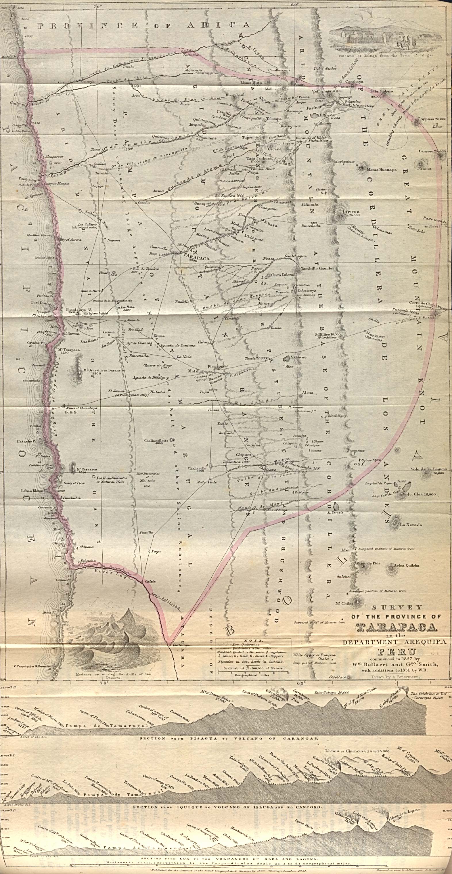
- Peru Arequipa Bölümü Tarapaca Vilayeti Araştırması 1827 yılında Wm tarafından başlatılmıştır. Bollaert ve Geo. Smith, 1851'e eklemeler ile W.B. İçinde: Londra Kraliyet Coğrafya Derneği Dergisi, Cilt. 21, (1851).
- Messrs. Richardson, Barth ve Overweg'den Oluşan Afrika Misyonunun Orta Afrika'ya İlerlemesi. İçinde: Londra Kraliyet Coğrafya Derneği Dergisi, Cilt. 21, (1851), s. 130–221, 2 harita.
- Kuzey Kutbu Bölgelerinde Yiyecek Olarak Bulunan Hayvanların Dağılımına İlişkin Notlar. İçinde: Londra Kraliyet Coğrafya Derneği Dergisi, Cilt. 22, (1852), s. 118–127.
- Sör John Franklin, Spitzbergen Denizi ve Kuzey Kutbu Bölgelerinde Balina-Balıkçılık. İçinde: Londra Kraliyet Coğrafya Derneği Dergisi, Cilt. 23, (1853), s. 129–136, 2 harita.
- 1850 ve 1853 yıllarında Messrs. Richardson, Barth, Overweg & Vogel yönetimindeki keşif gezisinin rotalarını gösteren kuzey Afrika'nın bir kısmının haritası. Londra, E. Stanford, 1854.
- Arrowsmith ve Mitchell'e göre Avustralya ve Yeni Zelanda. Edinburgh; Londra; Dublin: A. Fullarton & Co., [1858?]. (birkaç sürüm).
- İngiliz Admiralty Survey 1828-1849'a göre Grecian ArchipelagoAugustus Petermann tarafından çizilmiş, G.H. Swanston tarafından oyulmuş, 1860 dolaylarında Fullerton tarafından basılmıştır.
- Avustralya ve Yeni Zelanda. Edinburgh; Londra: A. Fullarton & Co., [1872].
- Peru-Bolivya Tablelands; Pentland, Parish, Fitzroy Meyen, Arrowsmith & c. & c. Augustus Petermann, F.R.G.S. tarafından inşa edilmiştir. G.H. Swanston. Haritalar 2–4: Amirallik Anketlerine göre Şili, Amerika Birleşik Devletleri Expn. J. Bartholomew Junr. F.R.G.S.
- M. Gerhard Rohlfs'in Marocco ve Tuat Üzerinden Yolculuğu, 1863–64. İçinde: Londra Kraliyet Coğrafya Topluluğu Tutanakları, Cilt. 9, No. 2 (1864–1865), s. 79–80
- Kuzey Kutbu'na Önerilen Seferde. İçinde: Londra Kraliyet Coğrafya Topluluğu Tutanakları, Cilt. 9, No. 3 (1864–1865), s. 90–104.
- Kuzey Kutup Keşfi Konusundaki Sir Roderick I. Murchison'a İkinci Mektup. İçinde: Londra Kraliyet Coğrafya Topluluğu Tutanakları, Cilt. 9, No. 4 (1864–1865), s. 114–125.
- Almanya'nın Kuzey ve Orta eyaletleri, Augustus Petermann tarafından çizilmiş, F.R.G.S., J. Bartholomew tarafından oyulmuş, A. Fullarton & Co, London & Edinburgh, c. 1870.
- Kuzey Kutup Bölgesi Keşfi Üzerine. İçinde: Londra Kraliyet Coğrafya Topluluğu Tutanakları, Cilt. 12, No. 2 (1867–1868), s. 92–113.
- İngiliz Guayana / Augustus Petermann F.R.G.S. tarafından çizilen Sir Robert Schomburgk'a göre. G.H. Swanston. A. Fullarton & Co. Londra, Edinburgh & Dublin, 1872.
- Karadeniz ve Hazar Denizi'nin Kuzey Kısımlarıyla Kafkasya ve Kırım, IX. Huot & Demidoff'a göre Kırım. Çizilmiş ve Oyulmuş J. Bartholomew, Edinburgh. (ile) Kafkasya Profr. Dr. Karl Koch, Augustus Petermann, F.R.G.S. G.H. Swanston. A. Fullarton & Co. Londra, Edinburgh ve Dublin. 1872.
- Kuzey Atlantik Okyanusu'ndaki Danimarka Adaları. XII. Augustus Petermann F.R.G.S. tarafından çizilen Gunnlaugsson'un Trigon Araştırmasına göre İzlanda. G.H. Swanston. 1872.
- Arktik Bölgelerinin Keşfi. İçinde: Londra Kraliyet Coğrafya Topluluğu Tutanakları, Cilt. 19, No. 2 (1874–1875), s. 173–180
- "Orta Afrika Keşiflerinde Önemli Noktalar". İçinde: New York Amerikan Coğrafya Derneği Dergisi, Cilt. 7, (1875), s. 324–328.
- Almanya = Deutschland[kalıcı ölü bağlantı ] / Augustus Petermann tarafından yapılmıştır; Peter ve Galpin; I. Dower tarafından oyulmuştur. Londra, Ward & Lock. 1880.
'Mevcut' coğrafyaya olan ilgi alanının, sadece Stieler'in El Atlası güncellemesiyle eşleştirildiğinde keskinleştiğini görmek şaşırtıcı değil. Haritacılığın coğrafi doğasını vurgulayarak, Ritter'in politik-tarihsel okulunun bir takipçisinden çok Humboldt'lu olduğunu gösterdi. Linke vd.[9] 1986'da şöyle yazdı: "Petermann’ın çalışmalarının bu yıllarda İngiliz haritacılığının yüksek standartlarına katkıda bulunduğuna hiç şüphe yok". T.W. Freeman, "1851 Sayımında Ağustos Heinrich Petermann tarafından, İngiltere'de Johnston harita firması ile Edinburgh'ta ve daha sonra Londra'da uzun süre kaldığı süre boyunca (1845-54) ince haritaların üretildiğini, ancak ayrılmasından bu yana standartların düştüğünü" belirtti.[10] ". 1852 ve 1853'te Petermann Britanya'da kolera üzerine bazı haritalar yayınladı ve haritanın tablolardan daha iyi olduğunu açıklayarak, Heinrich Berghaus'un kitabında belirttiği örneği takip ederek hastalığın ilerlemesini ve kurban yoğunluğunu gösterebileceğini açıkladı. Physikalischer AtlasBand II, Abt. VIII, hayır. 2 (1847). Bunları daha sonra ikinci baskısında Keith Johnston takip etti. Doğa olaylarının fiziksel atlası[11] (1856).
Haritalar Kraliyet Coğrafya Derneği Dergisi (Bildiriler) aracılığıyla görüntülenebilir JSTOR.
Petermanns geographische Mitteilungen (PGM)
Ayrıca bakınız: Petermanns Geographische Mitteilungen (1855–2004) [1][2]
Derginin başlangıcı
"Petermann, 1850'lerin başından itibaren, iki Gotha yayıncısı Wilhelm ve Bernhardt Perthes ile özel ve ticari temaslarını sürdürdü ve Haziran 1853'te aslında Gotha'da kısa bir süre geçirdi."[12] Mali zorluklar ve diğer birçok faktör, Perthes'in 1854'teki iş teklifini kabul etmesine neden oldu. Alman kariyerinin başlarında Petermann, Göttingen Üniversitesi'ne ilk profesör (1854) ve daha sonra fahri doktor (1855) olarak atandı. Gotha Dükü. Bernhardt Perthes, coğrafi enstitüsünün kurulmasında önemli bir rol oynama umuduyla onu işe aldı. Aynı zamanda arkadaşı Henry Lange Perthes ile de çalışmaya başladı. Petermann'a eşit bir pozisyonu reddedildiğinde Perthes'den ayrıldı ve çalışmaya başladı. Brockhaus Petermann Gotha Enstitüsüne gittiğinde orijinal planın bir parçası, Geographisches Jahrbuch Heinrich Berghaus'un 1850'den 1852'ye kadar düzenlediği (Coğrafi Yıllığı). Yönetici Adolf Müller'in (1820-1880) önerisiyle, bunun yerine aylık olarak yayımlanmasına karar verildi. Mittheilungen aus Justus Perthes Geographischer Anstalt über wichtige neue Erforschungen auf dem Gesamtgebiet der Geographie von Dr. A. Petermann[13] (PGM) (Justus Perthes Coğrafya Enstitüsü'nden tüm coğrafya alanındaki önemli yeni çalışmalarla ilgili, Dr. A. Petermann tarafından yazılan bildiriler). Bunlar 'gündelik sayılarda' yayınlanacaktı. Perthes atlaslarının birçoğuyla olan ilişkileri, 1855'in ilk sayısının önsözünde açıkça açıklanmıştı:
"'İletişimlerimiz', yeni coğrafi keşiflerin sonuçlarını hassas bir şekilde uygulanmış ve dikkatle ayrıntılı haritalarda özetleyecekleri ve grafiksel olarak gösterecekleri için tüm benzer yayınlardan farklı olacaktır. Bu nedenle dergimizin her sayısında bir veya daha fazla harita eki ve bunların tasarımı yer alacaktır. Stielers Hand-Atlas, Berghaus's Physical Atlas ve diğer harita yayınlarına sahip olanlara özel önem vererek, yönetimi kolay biçimde sürekli ve kolay erişilebilir bir ek garanti edecektir.Perthes Enstitü. Okurlarımıza her zaman önemli yeni keşifleri hemen veya olabildiğince hızlı bir şekilde sunmaya özen göstereceğiz. "[14]
Aynı önsözde, 'Mittheilungen'in ana odağını fiziksel ve biyo-coğrafya, jeoloji ve diğer doğal fenomenler ve daha az ölçüde etnografya üzerine koydu. En büyük gücü, beraberindeki haritalarda yatıyordu, çünkü bunların coğrafi keşif sonuçlarını en iyi şekilde göstereceği düşünülüyordu. Maceraya aç, ancak henüz tamamen bilimsel olarak okuryazar olmayan bir çağda, bu, mümkün olan en büyük ilgili okuyucu grubunu çekmenin en iyi yoluydu. Haritalar yalnızca birkaç Perthes atlasını desteklemekle kalmadı, aynı zamanda yeni temalar üzerinde ayrıntılı bilgi vermek için bir forum olarak kullanıldı ve böylece haritacılığın tematik kapsamını genişletti. Haritalara yaptığı vurguyu yeniden yazarken ifade eder. Geographisches Jahrbuch:
"İlk olarak, tüm coğrafi araştırmaların, keşiflerin ve araştırmaların nihai sonucu ve nihai hedefi, dünya yüzeyinin tasviridir: harita. Harita, coğrafyanın temelidir. Harita, bize dünyamız hakkında bildiklerimizi gösterir. En iyi, en net ve en kesin yol Çağdaş harita, dünya yüzeyini öyle tasvir etmelidir ki, kişi sadece yatay konumlar ve tüm noktalar ve yerler arasındaki mesafeleri ölçmekle kalmaz, aynı zamanda deniz seviyesinden en yüksek zirvelere kadar dikey değişimleri de açıkça ayırt edebilir. "[15]
Petermann, derginin ilk yıllarındaki haritaların çoğunu çizmekten sorumluydu. Gücü, mevcut tüm kaynakların analizi ve değerlendirmesindeydi. Öyle ki, pek çok başlıktaki 'Originalkarte' (orijinal harita) göstergesinin, kaşiflerin veya diğer uzmanların çizdiklerini kölece kopyalanan çok az kişi için iyi kazanıldığı söylenebilir. Alman coğrafyacılar gibi Hermann Wagner (1840–1929), diğer coğrafi dergilerde kaşif haritalarının önce haritacılar tarafından değerlendirilmek yerine kopyalandığını iddia etti. Son keşif raporlarına dayanan haritalar, mümkün olduğunda her zaman önceki keşiflerin rota haritalarıyla tamamlandı. Kaynaklardan çıkarım yapmaktan veya tahmin yürütmekten hoşlanmıyordu, çünkü bu yanlış ölçümler verebilir, bu yüzden haritalarının çoğu büyük boşluklar gösteriyor. Bu konuda ne kadar haklı olduğu 1911'de Julien Thoulet Fransa toprakları için batimetrik haritalar hazırladı.[16] Bu dört haritada 153.821 mil kare (398.390 km kare) başına sırasıyla 15, 31, 154 ve 308 yükseklik ölçümüne dayanan varsayımsal izobatlar çizer.2) Fransa ve komşu bölgeler için. (Yağış ve sıcaklık haritaları için makul sayıda ölçüm noktası, bu fenomenler için kabul edilebilir izolin haritaları oluşturmak için 100.000 km²'de sırasıyla 1.500 ve 600 olacaktır.[17]). Bunlar, bölgenin gerçek rahatlamasına neredeyse hiç yaklaşmayan şematik negatif kabartma haritaları verir. Thoulet, geniş okyanuslar için mevcut olan birkaç batimetrik ölçümün, okyanus tabanlarının gerçek rahatlamasına yalnızca belli belirsiz bir şekilde yaklaştığını göstermek istedi. Petermann keşif haritaları için sezgisel olarak aynı fikre sahip olmalıydı. Bununla birlikte, başkalarının bunlardan yararlanabilmesi için taslağını hazırladığı haritalarda nokta yükseklikleri ve nokta derinliklerini tanıtmak istiyordu.
Teknik yenilikler
Öğretmeni Heinrich Berghaus'tan, metrik ölçeğin erdemini iyi anladıktan sonra, temsili fraksiyonu harita ölçeği olarak tanıttı, ancak daha iyi bilinen sözlü veya yerel ölçek. Metrik sistemin ve Greenwich'in ana meridyen olarak popüler kabulü, alımda daha yavaştı. Ancak Stieler's Hand-Atlas'ın dokuzuncu baskısı (1900–1905) ile bu süreç tamamlandı.
1870'de Petermann, okyanusların sıcaklık haritaları için kırmızı ve mavi renk şemasının kullanılmasını savundu. Projeksiyon yöntemlerinin sayısı makul bir oranda artmasına rağmen, birkaç iyi bilinen tür, örneğin stereografik ve ortografik ekvator projeksiyonları ve projeksiyonları Lambert, Flamsteed ve Merkator, en popüler kaldı. Petermann, yeni projeksiyon yöntemleri hakkında raporlar yayınladı. J. Babinet (1854) ve J. James (1857) ve G. Jäger, ancak onları pek kullanmadı. Petermann ve Ernst Behm (1830–1884; birçok ünlü Gothaer coğrafyacı ve haritacı gibi Behm de önce başka bir mesleğe sahipti. Coğrafi ticareti pratikte öğrenen bir hekimdi) hakkında birçok makale yazdı. jeodezi ve ölçme, diğer teknik ve teorik kartografik konulara nadiren dahil oldular. Petermann, baskı teknolojisiyle, özellikle de renkli litografi ile daha çok ilgileniyordu. 1870'lerde bu şekilde birçok renkli harita üretmiş olsalar da, giderek daha fazla harita elle renklendirmeye geri döndü, çünkü daha sonra litografiden daha ucuz hale geldi. Stams'a göre,[18] Gotha Enstitüsü, on yıl içinde tüm kartografik ürünleri için yaklaşık 2.500.000 elle boyanmış harita veya günde 800 tane üretmiş olabilir! Petermann, ölümünden önce yayımladığı son makalesinde, yeni geliştirilen fotogravür Bu, harita başına maliyetleri önemli ölçüde düşürürken aynı zamanda üretim hızını da artırdı. Ona göre 715 sayfalık Avusturya haritası, kazınmış bir versiyondan muhtemelen yirmi kat daha verimli üretildi, çünkü üretimi yalnızca beşte birini ve maliyetlerinin dörtte birini alıyordu. 1857'de Kraliyet Coğrafya Derneği Başkanı , Sör Roderick Murchison, PGM'yi çeşitli keşiflerle ilgili hızlı haberlerinden ötürü övdü ve öncelikle İngilizler tarafından desteklenen keşiflerin önce İngiltere'de yayınlanması gerektiğini düşünen kendi Topluluğundaki kişilerin kıskançlığına karşı konuştu: Perthes Enstitüsü'nün bilimsel coğrafi söylemi zenginleştirdiğini düşünüyordu.[19]
'Petermann okulu', 'Gotha okulu' olarak da bilinir
Perthes müessesesinin başına atanmadığından, Petermann sadece mevcut diğer becerilere rehberlik edebildi. Neyse ki, becerilerini uzun süredir adamlarla olan deneyimleriyle geliştirmiş haritacıları ve oymacıları arayabilirdi. Adolf Stieler, Stülpnagel, Heinrich Berghaus, Emil von Sydow gibi yeni haritacıların yanı sıra Carl Vogel ve Hermann Berghaus. Göre Hermann Wagner bu çalışanlardan herhangi birinin kuruluşun başı olarak atanması akıllıca değildi. Bunun yerine firma, haritacı değil, ekonomi yöneticisi olan Adolf Müller tarafından yönetildi.[20]
Petermann'ın eğittiği haritacılar dahil Bruno Hassenstein (1839–1902), Hermann Habenicht (1897'den itibaren PGM'nin 20. yüzyıl editörü Hermann Haack'ı eğiten 1844–1917), Ernst Debes (1840–1923. Carl Vogel'e rakip olabilirdi, ancak 1868'de Gotha Enstitüsü'nden ayrıldı ve Alman referans atlaslarının altı ünlü ailesinden birini yayınlayan kendi firması [Heinrich] Wagner & Debes'i birlikte kurdu. E. Debes neuer Handatlas, daha sonra aradı Grosser Columbus Weltatlas), Carl Barich, Arnim Welcker (1840–1859), Ludwig Friederichsen (1859'dan 1863'e kadar Stieler ve PGM'de çalışan ve daha sonra Hamburg'un coğrafi toplumunu kuran ve Alman sömürge siyasetinde çok aktif hale gelen) 1850'lerde ve Fritz Hanemann (1847-1877), Christian Peip (1843-1922) ), Bruno Domann ve Otto Koffmahn (1851–1916), 1860'larda.[21] Kısa sürede öğretmenlerininki kadar iyi ve sonunda daha da iyi haritalar üretmeyi öğrendiler. Ancak, Petermann harita yazılarında, yükseklik rakamlarında bir iyileştirme ihtiyacına işaret ettiğinde muhtemelen iyi dinlemişlerdi (yükseklik ve batimetrik rakamlar topografik haritalarda ve çizelgelerde yaygın olsa da, bunları coğrafi haritalara ilk dahil eden Petermann'dı), daha doğru gravür ve daha iyi renklendirme, çünkü onun talimatları altında Stieler'ın haritaları ifade açısından daha tekdüze hale geldi. Bu konuda, aynı zamanda Vogel'in tutarlı olandan daha fazla çalışması ve Von Sydow'un kendi eserinde belirli stillerin avantajları ve dezavantajları ile ilgili eleştirel yorumları tarafından yönlendirildiler. Kartographischen Standpunkt Europas.
Petermann ayrıca fiziksel özellikleri arka plan olarak kullanmak istiyordu. tematik haritalar, öğrencilerinin izlediği bir fikir. Herbert Louis 1960 yılında tematik haritaların altında yatan arazinin yükseklikleri, hidrolojik ağları, yerleşimleri ve trafik yollarını göstermesini talep ettiğinde, Petermann'ı nüfus haritalarının temeli olarak bir arazi haritasını kullanan ilk haritacı olarak gösterdi.[22] Onun için temel olarak hachuringi kullanarak Karte des Österreichischen Kaiserstaates zur Übersicht der Dichtigkeit der Bevölkerung nach dem Census von 1857 (1857 sayımından sonra nüfus yoğunluğuna genel bir bakış olarak Avusturya imparatorluk devletinin haritası, 1860) ve harita Die Ausdehnung der Slaven in der Türkei und den angrenzenden Gebieten (Türkiye'deki ve komşu bölgelerdeki Slav nüfusunun genişlemesi, 1869) Petermann, öğretmeni Heinrich Berghaus'un yirmi yıl önce başlamış olduğu jeolojik, iklimsel ve etnografik verilerin temsiline devam etti.
Bölümler
Dergi başından itibaren coğrafyadaki gelişmelere ilişkin küçük mesajlar başlığı altında yer almıştır. Geographische Notizen / Monatsbericht (1855 –....). Bunlardan bazıları, özellikle kitap alıntıları olmak üzere son zamanlarda yayınlanan literatürle ilgiliydi. 1860'da Petermann, bunların daha yapısal bir şekilde listelenmesi gerektiğine karar verdi; ikincisi geçici olarak Geographischer Literatur Bericht für **** (1886–1909) olarak, belki de Kroner'in Zeitschrift für allgemeine Erdkunde 'Gesellschaft für Erdkunde'. Kitaplar ve haritalar, Perthes kütüphanesinin bir parçası olsalardı, yalnızca listelenmez, aynı zamanda gözden geçirilirdi. Çoğu listenin aksine, ana dergilerden makaleleri de kapsayacaktır, çünkü bunlar, coğrafyadaki en son gelişmeleri yansıtan birincil kaynaklardı. Bu, PGM okuyucularını güncel tutacaktır. Derginin diğer bölümleri şunlardı: Geographische Nekrologie des Jahres **** (1858–1884), Geographie und Erforschung Polar-Regionen (no. 51/1871-nr. 135/1878), Monatsbericht über Entdeckungsgeschichte und Kolonizasyon (1885), Kleinere Mitteilungen (1889–1939), Geographischer Anzeiger (1899–1902), Kartographischer Monatsbericht aus Justus Perthes'in Geographischer Anstalt Gotha'da (1908–1911), Militärkartographie (1909–1914), Staaten und Völker (1923), Neue Forschung im Felde (1935–1939), (Wehr- und) Militärgeographie (1935–1936), Kartographie (1941–1945).
Bilinmeyeni haritalamak
Petermann'ın adı yüzlerce haritada görünse de, Wagner 1862'den sonra harita hazırlamayı bıraktığını öne sürüyor.[23] İlgili rapor Nordenskiöld Yolculuk Lena ve Amerika Birleşik Devletleri ve Avustralya haritaları bunun doğru olmayabileceğini gösteriyor. Belki de artık Barth haritalarındaki gibi haritaları tasarlamadı, inşa etmedi ve taslaklarını hazırlamadı, ancak büyük olasılıkla haritaların, özellikle de ilgi alanındakilerin tasarımında ve tasarımında rol oynamaya devam etti.
Petermann, topografik haritaların bile henüz gerçekliğin gerçek bir temsili olmadığının çok iyi farkındaydı (bu, Liparian Adaları Darondeau'nun 1858'deki Fransız araştırmasına kadar güvenli bir şekilde yerleştirilmemiş olan[24]), kıtaların iç kısımlarının ve kutup bölgelerinin orta ve küçük ölçekli haritaları bir yana. Hala yoğun topografik, orografik ve hidrolojik bilgilerden söz edilebilir. Stieler'deki haritalar bilgiyle yoğun görünse de, çoğunlukla görüntüdeki boşluğun izin verdiği yerlerde bilgilerle doluydu ve haritacıların bilinen fenomenlerin yokluğuyla neyi tasvir edecekleri konusunda çok az seçeneği vardı. Bilginin yoğunluğu, haritacılar verilerini seçip haritaları mümkün olduğunca dengeli bir görüntü verecek şekilde tasarladıkları için bir alanın ne kadar kapsamlı bir şekilde araştırıldığını göstermiyordu. Petermann'ın 1866'da söylediği gibi:
"Aslında, dünyanın bölgeleri hakkındaki kartografik bilgimiz genel olarak sandığımızdan çok daha az. ... [Haritalarda] Afrika ve Avustralya toprakları bile gittikçe küçülüyor ve [sadece] birkaç tane kaldı boş noktalar, belki de "hiçbir şeyin" olmadığı "vahşi bölgeler". Gerçekte haritalarımızda gördüğümüz her şey sadece ilk adım, dünya yüzeyine ilişkin daha doğru bir bilginin başlangıcıdır. "[24]
Sadece PGM'deki pek çok alanın boş bırakıldığı ayrıntılı haritalarda, coğrafi bilginin ne kadar gelişigüzel ve eksik olduğu gerçekten yargılanabilirdi. J.G. Bartholomew in 1902 phrased Petermann's drive as: "The filling up of the blank spaces of the unknown in his maps had such a fascination for him that rest seemed impossible to him while any country remained unexplored".[25]
The results of the exploratory expeditions cried out for presentation in map form, and PGM published exploration results as quickly and accurately as possible. Petermann had all results he received from explorers checked against the considerable information and maps available in the Perthes Institute. This fund of knowledge grew to be so large that the Institute soon had a large library of manuscripts, books, atlases, and maps at its disposal that could vie with any university or society collection. In the 1980s it was thought that the Perthes-archives contained 180,000 printed maps and around 2,800 atlases.[26] 1990'larda tahmin was 1,000 m of archive, some 400,000 maps (including manuscripts), and some 120,000 geographical works. All collections (currently estimated at 185,000 sheets of maps, 120,000 geographical works, and 800 m of archives) were acquired in 2003 by the Free State of Thüringen and deposited with the library of the Erfurt Üniversitesi in its research center in Gotha.
But the maps went beyond a simple presentation of the itinerary by also describing the area explored with all knowledge available and pointing out gaps that remained to be filled in the current knowledge. So the impact was reciprocal. Moreover, Petermann gave directions to explorers in exchange for which he was allowed to publish their results as soon as possible.
Richardson's African expedition
The influence Petermann tried to wield, even as a young man, can best be illustrated by his interference, together with Bunsen and Ritter, on behalf of Heinrich Barth, who wished to take part in the Richardson expedition. He later also persuaded the English government to send Eduard Vogel after them for scientific research and astronomical observations. Petermann published the results under the title Account of the expedition to Central-Africa. When first Barth and later Vogel failed to return at the expected time Germany frantically tried to discover their fate, much as Britain had with Franklin in the Arctic area. This led to many new German expeditions to Africa (by Theodor von Heuglin, Hermann Steudner, Theodor Kinzelbach, Karl Moritz von Beurmann, Gerhard Rohlfs, Karl Mauch and others), most financed by gifts due largely to Petermann's agitating actions and publications. Many found their death in Africa as shown in the map with the subtitle Four martyrs of German science in Inner-Africa shows, i.c. Overweg, Vogel, Beurmann and Steudner.
Petermann first drafted maps of Barth & Overweg's routes for the journal of the German Geographical Society and followed these up with maps in PGM in 1855, 1857, and 1859. These were later worked into the maps for Barth's voluminous work on his African voyage of 1850–55.[27] The route maps were used in new maps up to 1893.When we compare the maps in Barth's work and in PGM we may get an idea of how the information was turned into images. The first map in Barth's work gives an overview of his routes. The routes of Livingstone have already been engraved, but have not been highlighted by coloring. The 1857 issue of PGM uses the same copperplate, but with both routes highlighted and another title. Sheets 2–14 of Barth's work are route maps on the scale 1:800,000 and 1:1,000,000. In 1855 PGM gives only a summary of the routes of the first half of the total tour, on scale of 1:2,100,000, with added profiles along the borders that do not appear on the detail maps. This was a corrected issue of a map first published in London.[28] In the 1857 issue the map of Touareg-country is a copy, but mainly uncolored. Maps 15 and 16 of Barth's work form a beautifully drafted and colored two-sheet map at a scale of 1:6,000,000 and measures 57 x 85 cm. It depicts the approximate territories of the indigenous tribes. The other maps in the 1857 issue show rather small details of the routes, not beautifully executed, while in the text a plan of Agades is inserted (I do not know if it exists in Barth's work). All in all, there is little overlap, also because the scales used for the different works are mostly different. But the smaller maps are clearly generalizations of the maps in Barth's work. The images in Barth's look sharper, but of course that is also because they are engraved on a larger scale, while all the areas outside the routes, of which nothing or not enough is known are blank.These routes, like many others, were reused in many new maps, such as Barth's route, supplemented with the 1828 routes of René-Auguste Caillé (1799–1838) and Léopold Planet (1850).
Invitation for exploring Africa
PGM not only reported the findings of explorers but also was proactive in instigating new explorations. Ergänzungsband II of 1863 contains a 10-part map (210x102 cm) of Africa (Karte von Inner-Afrika,[29] that contained all routes of explorers between 1701 and 1863. The most important parts of the map are the blank areas, hoping that they would stimulate explorers to go on expeditions to find out what new things there could be. But it was also a case of marketing PGM, as shown in the memoire that accompanied the map, where Petermann wrote:
"The basic idea of our map was to give travellers a sure support for the choice of their routes and guarantee the direction of the explorations, to resolve doubts and stimulate the elucidation of the unknown, and to offer a means for friends at home to follow their moves and to judge the value of their labour. This by creating a cartographic representation of the least known central regions of Africa utilizing all material at hand as completely as possible, to display the range of our contemporary knowledge as well as the way this knowledge is acquired and the degree of its reliability."[30]
Arktik keşifler
Petermann spent a lot of time on the active promotion of his exploratory missions, especially the polar regions.[31] For this he wrote more articles than for any of his other ventures. Up to 1871 he published seventeen maps of the Arktik ve Antarktika in the regular issues and eight in the 'supplement' issues. He began publishing notices on the geography and exploration of the polar regions in PGM 38, 1871 (Geographie und Erforschung der Polar-Regionen started in 1865 and nos. 51–135 appeared in PGM volumes 16, 1871 to 23, 1878), and from that time onwards 195 maps covered the polar regions, but none appeared in the supplements of that period. He actually started to push his interest in this subject in the 1865 issue of PGM and with the publication of supplement 16 (Ergänzungsband IV ) in 1865. In the PGM-issue he recites the correspondence he has with the Royal Geographical Society (RGS) concerning the proposal of capt. Sherard Osborn (1822–1875) to send another English expedition to the North pole starting from Baffin Bay. In several articles he tries to persuade the RGS to support his plan to start the expedition from Spitsbergen and use steamships instead of sledges for transport. In one article he stresses his love for Arctic expeditions by reminiscing: "Who, like us, e.g. has attended the accounts of one capt. Inglefield (Edward Augustus Inglefield (1820–1894)) during the session of the Royal Geographical Society of London on 22 November 1852, would be persuaded to know that the natural beauty of the Arctic regions cannot be surpassed by any other in the world."[32] Though the accompanying map shows his theory concerning an extended Greenland he doesn't write about this, but mainly about his errouneous theory concerning the behavior of the Gulf Stream. Supplement IV gives an overview of the knowledge of the area around Spitsbergen and the central Arctic. It contains articles by Petermann, R. Werner, N. Dunér and A.E. Nordenskiöld, Dr. Malmgrén, Barto von Löwenigh, and G. Jäger, and is accompanied by three maps. Petermann published this supplement issue to encourage people and institutes to support German efforts to explore the central Arctic. The first map, scale 1:40,000,000 covers both the Arctic and Antarctica, with the routes of the explorers from pişirmek to 1861. He measures the unexplored area in the Arctic as 140,000 German square miles (approximately 7,700,000 km²), comparing it to Australia's total of 138,000. The unexplored Antarctic he calculates as 396,000 German square miles (approximately 21,800,000 km²). Petermann uses the map specifically to show the benefits of using ships for exploration, rather than the sledges usually used by the Americans and the British. He must have been convinced that the central Arctic contained vast expanses of open water and land, the latter presumably extensions of Greenland and Spitsbergen. Though the routes in the Antarctic map have been engraved, they are not highlighted in color. Instead Petermann has colored the polygons that encompass the areas covered by the several explorers. This highlights the unexplored area clearly, even though it is blank. But Petermann is definitely more interested in having the Germans explore the Arctic than the Antarctic, presumably because the costs of an Arctic expedition can be met more easily than those of an Antarctic one. The more detailed map of Spitsbergen not only shows the Swedish surveys of 1861 to 1864, but also the presence of coal fields, coastal areas with driftwood, and areas where reindeer can normally be found. Petermann's last map is in the modified polar projection first proposed by G. Jäger of Viyana. Jäger had developed this projection specifically to facilitate the palaeontological analysis of the inventory of animal life in the Arctic area. Petermann thought this the best projection for planning the laying of telegraph lines.
North-East passage
He not only promoted explorations, but also actively collected funds to realize them, and gave an account of the receipts and expenditures in several issues of PGM. 1865'te Otto Volger of the FDH (Freies Deutsches Hochstift für Wissenschaft, Künste und allgemeine Bildung, founded in 1859) organised the 'Allgemeine Deutsche Versammlung von Freunden der Erdkunde' (General German Assembly of Friends of Geography). During this two-day meeting G. Neumayer stressed the fact that Germany needed a German maritime institute to be independent of other nations. One of the programmed issues to be discussed was the issue of guidelines for the use of a homogeneous meteorological logbook for the German merchant navy. In later years the maps in PGM made much use of the data thus gathered. Petermann jealously reported on the marine surveys in Britain and America, which were realized with governmental support, and he dearly wished such was possible in other nations, especially Germany. Furthermore, he pointed out that Germany had much to win by exploring the Arctic region, especially the Kuzeydoğu Geçidi, since the English and Americans were concentrating on the Kuzeybatı Geçidi. Though he even tried to get Bismarck involved in an Arctic exploration project, it was shelved for some time because of the Austro Prussian war and the consequent expansion of the Prusya Diyar. In PGM that same year he again turned to the FDH for support. In 1868 Petermann roused so much support for his idea in the German public that his Arctic expedition actually took place.
He proposed to follow a course East of Greenland, for he and other geographers were convinced that Greenland stretched much farther North than was known in that time. Rağmen Ferdinand von Wrangel started a four-year-long expedition in 1820 to find possible land North of cape Shelagskiy and could not find any land he noted a Chucki chief saying: "One might in a clear summer’s day descry snow-covered mountains at a great distance to the North."[33] Heinrich Berghaus, Petermann's teacher, included this information in the right hand corner on his isotherm map of 1838 for his Physikalische Atlas with the text 'possible polar land' [Wahrscheinliches Polar-Land]. So it might be possible that Petermann based his views on this information.
He published the same map of the Arctic and Antarctic as in 1865, but now with Greenland stretching over the Arctic and ending in Wrangel Adası a yakın Bering Boğazı. It shows the possible route of the German expedition. The Antarctic map now uses only two colors to delimit the areas covered by James Cook ve diğerleri. Later in that volume he published two maps of the route sailed by the German expedition. Unfortunately, they discovered a finger of permanent pack ice stretching from the north to approximately 76°, which made progress further North impossible. Since we of course know this only by hindsight we can understand that Petermann was not daunted in his endeavors to reach the Kuzey Kutbu and demonstrate a possible passage to the Pasifik Okyanusu, even when this expedition had partly failed. In 1869 he published a map of the Kuzey Buz Denizi Kuzey Wrangel Adası with all exploration routes between 1648 and 1867 and a map with sea-temperatures in the Grönland Denizi ve Norveç Denizi as observed by the German expedition. And again two maps of the German expedition in Ergänzungsheft 28.
In 1874 he again published an overview map of the Arctic scale 1:16,000,000 now with all the routes from 1616 to the end of 1874, complemented with the new meteorological weather stations. Strangely enough the route of the 1868 German expedition is not engraved in the image. Petermann still believed, however, that Greenland stretched far into the Polar region. The text in the map reads: 'Unerforscht, wahrscheinlich Land oder Inseln (Petermann's Hypothese)’ [unexplored, probably land or islands (Petermann's hypothesis)].
In the case of the polar regions, Petermann's point of view deviated from most contemporary views.[34] While many, especially the Americans and British, saw a possible passage in the Northwest, where they expected to find a passage after rounding Greenland, Petermann thought this not a viable option. But this did not prevent him from publishing many reports and maps of the American and British explorations in this area, sometimes translated from the journal of the Royal Geographical Society and other geographical societies. Though he was right in hypothesizing that the warm Gulf Stream complemented the cold Labrador Stream and that the warm stream extended far north of Spitsbergen and Nova Zembla his thesis that it warmed the Arctic needed serious revision. Although he thought it to be a deep stream he did not realize the warmth from the 300 m depth could affect surface ice as deep it rounded Svalbard and followed shelf break bathymetry eastward. On the other hand, he was wrong about the extension of Greenland. O yazdı:
"... but such an enormous glacier like the one named after Von Humboldt points at extensive eternal snow and glacier regions and this speaks for an extension of Greenland to the North ..."[35]
His view may have been reinforced by some explorers who sighted land at higher latitudes than the tip of Greenland.While Petermann was honored in 1876 by the Amerikan Coğrafya Topluluğu, during the last week of a 3 weeks visiting the US, Dr. Isaac I. Hayes disputed the hypothesis of Petermann's land tongue stretching from Greenland to the Bering Denizi, though he agreed that the Kuzey Buz Denizi would possibly be open water.[36] In the Soviet Encyclopaedia the following is written concerning Petermann's hypothesis:
"He put forward the hypothesis of a warm Arctic sea and the existence of land in the central Arctic, dividing the sea in two. In 1874 Payer 'viewed' land north of Franz-Joseph-Land and put it on the map under the designation 'Petermann Land'. But during the ice drift of the Russian ship 'Saint Anna' (1912–1914) and the marches of the navigating officer W.A. Albanow it was established that it did not exist."[37]
The seeming impossibility of the Kuzeybatı Geçidi was acknowledged long after his death. Only in 1904 did Roald Amundsen achieve the passage. Ne zaman geldi Kuzeydoğu Geçidi his view that a passage was possible between Nova Zembla ve Spitsbergen proved right after Nordenskiöld's trip to the Ob ve Yenisey nehri, and this while encountering stiff opposition and bearing the weight of some failed German expeditions. The ultimate proof by Nordenskiöld's trip with the steamship 'Vega' sailing around the Taimyr peninsula was published in 1879 in PGM shortly after his death. Since the map was drafted on top of Petermann's earlier map of Siberia, from 1873, this might have been a way to honour Petermann. The route of the 'Vega' appeared on a Russian copy of Petermann's 1873 map, which was reason enough for the editors to add it in their 1879 map. The map shows clearly to what degree the descriptive data of older explorations (i.e. Vasili Pronchishchev ['Prontschischtschew'], 1735–36; Hariton Laptev ['Laptew'], 1739–43; Semyon Čeluskin ['Tscheljuskin'], 1735–43; Fyodor Minin and Dmitriy Sterlegov ['Sterlegow'], 1740; ve Alexander Theodor von Middendorff, 1843) could be trusted when drafting a map from many sources and trying to amalgamate them into a single image. The difference between the coastlines on the two maps sometimes can be as much as ½° latitude and 1° longitude.[38] Bakmak Taymyr Yarımadası, the channel between it and the mainland is reduced from approximately 10 km to a few kilometres by the Swedish exploration! The only exception was the information derived from P.F. Anjou (1823), which was based on astronomical observations, and is the same in both maps. The article (translations from Swedish and Danish with a preamble by Behm) and map appeared four months after the 'Vega' had arrived in Irkutsk. Hassenstein drafted the new map, maybe using the older draft. The title was hammered out of the old copperplate and replaced by a new one, while Nordenskiöld's data were engraved, and printed in red, making it look like an overlay on the old map. Because of the use of lighter background colors the newer map looks much fresher than the older one, though only six years lay between the two.
Avustralya
Petermann kept his promise, made in the preface of the first issue of PGM, when he was responsible for the new edition of Stieler's Hand-Atlas. He also had a weakness for Australia. Up to his death he published some 48 maps concerning exploration in (parts of) Australia, though hardly any of the expeditions bore any German influence. In 1866, when he gave an account of the first issue of the fifth edition (1866–67) of the Stieler, he frequently referred to maps or articles published in PGM. Furthermore, he mentions that he is working on four other maps of Australia or parts of it. One of these is his famous eight-sheet map of Australia, scale 1:3,500,000, and the other three are concerned with exploration or based on land-property maps. (Spezialkarte von Neu-Süd-Wales nach den Kataster-Aufnahmen, daha sonra olarak yayınlandı Spezialkarte eines Theiles von New South Wales (PGM, 12, 1866, table 13); Spezialkarte vom See’ngebiet im Inneren von Australien, daha sonra olarak yayınlandı Das See’n-Gebiet (Lake District) und die Steinige Wüste (Great Stony Desert) im Innern von Australien (PGM, 13, 1867, table 4); Karte der Entdeckungen im Inneren Australiens, scale 1:2,500,000, which he probably chose not to publish in PGM due to all the new discoveries). In 1871/72 he published the eight-sheet map as Specialkarte von Australien in 8 Blättern in Ergänzungsheft 29 (volume VI) and 30 (volume VII). It is a superb effort to compile all available knowledge in a colored map-image that measures 194x118 cm altogether, and it reminds us of the ten-sheet map of Africa of 1863. Being Petermann he would have liked to have accompanied it with a volume containing its ten-year history of exploration and discoveries, but in order not to raise the retail price of the map he satisfied himself with merely citing the volumes of PGM where the information could be found and providing an accompanying 43-page geographical-statistical compendium by C.E. Meinicke. In 1875 a second revised edition appeared, with a small sample in PGM.We unfortunately do not find his famous six-sheet map of the United States (Neue Karte der Vereinigten Staaten vor Nord-Amerika in 6 Blättern) in the issues of PGM. It was produced for the sixth edition of the Stieler on scale 1:3,700.000, though a small part appeared in the next annual as an illustration of the exploration of Northwest Texas.
Source interpretations
Several times Petermann indicated that he disagreed with the reports of explorers, probably basing his arguments on reports and literature at his disposal or on sound geographic reasoning. In a map, concerning among other things lake Uniamesi, he tends to disagree with Jakob Erhardt, one of the missionaries of the Kilise Misyonu Topluluğu of London, concerning its situation and extension. Erhardt was erroneous in that he situated the lower tip of the lake around 13° South 36° East and made it bend westward to 28° East, with a probable extension to 24° East. Furthermore, he thought that Victoria Gölü, Tanganika Gölü ve Nyassa Gölü were one inland sea extending to 6° North. A lack of data led Petermann to agree with his erroneous shape of the lake or lakes, but he was not convinced of its wide extension to the west and north. As for the sources of the Nil he was not so much mistaken, as they were indicated by a text near the equator between 30° and 36° East, but this was not so hard to induce. When one views the ethnographic and trade information in the map and interprets them from a relative topological point of view we can see this as the strength of the missionaries' reports. As their mission was focused on people and not on the natural environment this kind of information was of great importance to them. But geometrically their information could not be trusted, in part because most of their information was based on verbal reports of the native tribes.[39]
At other times he depicted maps of the same area from several authors together in one supplement map to show the authors' different interpretations. This was the case with, for example, the map of the Kerguelen ve McDonald Adaları sighted by John Heard (1853), William MacDonald (1854), Hutton (1854), Attway (1854), Rees (1854), and Neumayer (1857), with several comparisons of explorations since James Cook. The same with small maps (scale ca. 1:33,000,000) of the central part of southern Africa, which shows different interpretations by Heinrich Kiepert (1855), J. McQueen (1857) and David Livingstone (1857). Or with the representation of the Gabon countries, which show interpretations by August Petermann, Thomas E. Bowdich, William D. Cooley, Heinrich Kiepert, Paul Belloni du Chaillu ve Heinrich Barth.
Many times he included an outline map of Germany, or parts thereof or other countries to show the vastness through which the explorers had to travel. This must have contributed to the understanding and compassion the readers felt for the sacrifice and hardships the explorers had to go through to come to the results presented in the articles and maps.
Stieler-Handatlas
Since the first edition Friedrich von Stülpnagel had been mainly responsible for the drafting of the maps of Stieler-Handatlas. When Stülpnagel died in 1865 Petermann became responsible for the Stieler. He drafted some maps (e.g. Russland und Skandinavien, Süd-Polar Karte, Neu-Seeland, Avustralya, Süd-Ost Australien ) için the 4th edition (1863–1867), which reached 83 maps. İçinde 5. baskı (1868–1874) we can see the hand of the master clearer, as the maps become more uniform and the style of the 'Gotha School' becomes more distinct.
Fame for the armchair traveller
Petermann was sometimes accused of being an 'armchair' geographer as he never traveled wide or experienced new discoveries with his own eyes, but the quality of the maps and geographic ideas he produced proves the accusation unfair. Some people are better at observing and describing circumstances and phenomena, others are better at interpretation of data. Petermann's greatest accomplishment lay in the interpretation and evaluation of sometimes contradictory sources, and his great legacy is that he was able to develop this faculty in most of his pupils in such a fine way that geography at large has profited from it ever since. Should one criticize the journal under his direction for not being geographically innovative then one may come nearer to the truth. Many articles are of a descriptive physical nature, with many intimate details in the explorers' colloquial style, and hardly any tries to find explanations for the physical phenomena. Most emphasis is laid on jeomorfoloji ve jeoloji — old disciplines by then with their own technical language already — meteoroloji, botanik ve Biyoloji. İle ilgili makaleler antropocoğrafya usually reach no further than ethnographic descriptions of regions. It is still the era of data-gathering and in this they were not far beyond the kameralistik nature of the first half of the nineteenth century. One should have expected more articles concerning (parts of) Europe, but a count in the annuals for 1860–1864 shows that only 16% of the articles and 22% of the Kleinere Mitteilungen (small communications) concerned Europe. As accommodation one might say that the journal, though geographic by nature, was aimed at popular use. That was one of its strengths, as shown by its large circulation.
"Petermann’s achievement falls in a period in which raw material was gathered, especially through explorations. It was the flowering of geographic dilettantism. Interest was not only stirred by news as such, but the news in itself was interesting, because every educated person without special prior knowledge could understand it."[40]
According to Weller, Petermann signed 226 articles in Petermanns Geographische Mitteilungen, including 41 on Africa, 98 on the Polar regions and 37 on the history and use of cartography. The same source puts his total production of maps at 535, including his maps for the Stieler, the Physical atlas and several miscellaneous items. Stams, using the ten-year indexes, counts 280 maps in Petermanns Geographische Mitteilungen that can be said to have been constructed and edited by him.
Slipping and death
At the end of the 1870s geography started to change its objects and goals, which upset the previously important position of what was then called the 'Gotha Academy'. Ne zaman Charles Darwin yayınlanan The descent of man it was the beginning of the expansion of human geography, which till then was only rarely focused upon, except in the field of ethnography. The physical-deterministic view of humanity that followed led to the rise of the branch of geography we now call anthropogeography, especially after 1875, when Friedrich Ratzel (1844–1904) was the first new professor of geography appointed in München and later Leipzig (only Carl Ritter ever before had been professor of geography worldwide).
In 1856 Petermann had married Clara Leslie and had two daughters with her. They were divorced in 1875. A year later he married for the second time. As time wore on he seemed to have suffered more and more from family problems. It is also supposed that for many years he suffered from manic-depressive moods and he seemed to have always kept a revolver in close proximity.All these changes and troubles may have contributed to the fact that Petermann died by his own hand at Gotha on 25 September 1878. The fact that Gotha was becoming less exclusively the center of exploration – which so enchanted the large masses—and became more scientifically focused might also have played a role.In 1902 J.G. Bartholomew wrote: "It is only a fair tribute to Augustus Petermann to say that no one has done more than he to advance modern cartography, and no man has ever left a more fitting monument to himself than his Mitteilungen, which still bears his name, and under the editorship of Dr. Supan, is the leading geographical authority in all countries. But to the absorbing fascination of his work Petermann sacrificed all other interests in life and died a martyr to geography".[41] That fame perished quickly was shown by Hermann Wagner in his article of 1912, when he commemorates the merits of the Gotha epoch under Petermann and finds that nobody up till then had written about the making of the history of geography and cartography and that all those pioneers were all but forgotten, even though the journal carried Petermann's name since 1879.In 1909 a monument with Petermann's effigy from the workshop of Max Hoene-München of Gotha was erected in the Ducal gardens of Gotha, a stone's throw away from the institute where he had worked for so many years. The monument was offered by the German geographical societies. Petermann in his time was well paid by Perthes as is shown by his beautiful villa close to Gotha's railway station.
Petermann lives on
Because Petermann provided so much supporting work during his lifetime, several physical features, especially in the Arctic, were named after him. İçinde NIMA-database the following seven toponyms are listed: Petermann Sıradağları (Antarktika), Petermann Adası, also in Antarctica, Petermann Ranges (Avustralya), Petermann Zirvesi, Petermann Fiyordu, Petermann Buzulu, Petermann Yarımadası, Kapp Petermann. According to Hugo Wichmann, Capt. Bullock was probably the first to name a physical feature after Petermann, on a printed English chart of 1860.[42] In the same report he counts thirteen features in Asia, Australia and New Zealand, and the Arctic and Antarctic regions, named between 1860 and 1874. Some of them were renamed by other explorers and one turned out not to exist, Petermannland, an island North of Zemlya Frantsa-Iosifa (Franz Josef Land) sighted by Capt. Fligely and named by Julius Ödeyen, which later proved nonexistent. Biz[DSÖ? ] may keep this name in mind, however, as a proof of Petermann's vision and drive to have the region explored, though this sometimes revealed different physical objects than he had hypothesized. In a later age, even a crater on the moon was given the name Petermann crater, situated halfway between Mare Humboldtianum and Peary in the northern polar region.
Petermann thought that the naming of newly discovered physical features was one of the privileges of a map-editor, especially as he was fed up with forever encountering toponyms like 'Victoria', 'Wellington', 'Smith', 'Jones', etc. He writes: "While constructing the new map to specify the detailed topographical portrayal and after consulting with and authorization of messr. [Theodor] v[on] Heuglin ve say Karl Graf von Waldburg-Zeil I have entered 118 names in the map: partly they are the names derived from celebrities of arctic explorations and discoveries, arctic travellers anyway as well as excellent friends, patrons, and participants of different nationalities in the newest northpolar expeditions, partly eminent German travellers in Africa, Australia, America ..."[43] So the accompanying map of Svalbard is larded with features named after Barth, Behm, Berghaus, Bessel, Brehm, Breusing, Heuglin, Hochstetter, Koldewey, Lange, Mauch, Oetker, Payer, Perthes, Petermann, Ravenstein, Weyprecht, and Wilhelm.
Bir devrin sonu
1993 yılında Justus Perthes Verlag, the publisher of PGM, was taken over by Ernst Klett Schulbuchverlag in Stuttgart. In 2003 the Perthes archives (180,000 maps, 120,000 geographic publications, and 800 m of business archives) were bought by the Free State of Thüringen and deposited in the Gotha annex of Erfurt University. In 2004, after 149 years of publication, the journal Petermann’s geographische Mitteilungen ceased to be published. The municipality of Gotha bought in 2010 the business premises and the accompanying grounds on Justus-Perthes-Straße 1–9 and Gotthardstraße 6, and has started renovating the former for a future Perthesforum for research and exhibitions. The Perthes family villa at Gotthardstraße nevertheless was demolished in July 2012 for lack of development options.[44]Many of the letters Petermann sent or received have been saved for future study, as also are the drafts he made for many maps, and are kept in the Perthes Collection of the Erfurt Üniversitesi Gotha Research Library.
Fotoğraf Galerisi

Petermann's map of the bay of Süveyş (1856)

Sayfasından bir sayfa Stielers Handatlas with credit, "Von A. Petermann." Many of his maps are credited in German as "Von A. Petermann." meaning, "By A. Petermann."

Front page of the 1st edition of Petermanns Geographische Mitteilungen (1855)

The house where Petermann was born: Neue Straße 3, Bleicherode
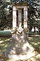
Petermann's grave at the cemetery of Gotha

Memorial for August Petermann in his hometown Bleicherode

Perthesforum


Ayrıca bakınız
Notlar
- ^ A solid promise made in the introduction to the first issue of Petermann's geographische Mitteilungen in 1855, a promise that was kept up till the demise of the journal in 2004.
- ^ Petermann’s Geographische Mittheilungen 106(1962), table 123
- ^ Johann Christian Poggendorff; Sächsische Akademie der Wissenschaften zu Leipzig (1863). Biographisch – literarisches Handwörterbuch der exakten Naturwissenschaften. Akademie Verlag. pp.5 –. Alındı 24 Ağustos 2011.
- ^ From his early years he had excerpted 'everything new, which becomes available in the geographical sciences', and these excerpts were sorted and well organised in his Kollectaneen. This habit led to his 'geographischen Hefte' (geographic notebooks) ... (Engelmann, Gerhard. 1960. August Petermann als Kartographenlehrling bei Heinrich Berghaus in Potsdam. In: Petermanns Geographische Mitteilungen 106, p. 178). They also contained hundreds of pages of lectures by Von Humboldt, Ritter, Hoffman, Pöppig, Erdman, etc. which he later plagiarised in some of his books. He used this word himself in his schoolbook Ersten Elementen der Erdbeschreibung: Plagiatoren sind die Gladiatoren auf den Tooneel-Brettern der Geographentruppe (Plagiarists are the gladiators on the stage floor of the geographers' company') (Engelmann, Gerhard. 1977. Heinrich Berghaus, der Kartograph von Potsdam, s. 167). He alluded here to the way Ortelius had conceived the Theatre oft Tooneel des Aerdtbodems in 1571, though to be fair to Ortelius one should note he cited his sources in his Catalogus auctorum tabularum geographicarum.
- ^ Geographische verbreitung der menschen-rassen. ubersicht der nahrungsweise und der volksdichtigkeit in den ackerbaulandern, Auch manches zur physik des menschen. 7te abtheilung: Anthropographie no 1. gezeichnet u. gestochen in der geogr. Kunstschule zu Potsdam. Gotha, J. Perthes, 1848.
- ^ Charles P. Daly, president of the American Geographical Society criticized this behavior in his address to the society while speaking of Animaxander's introduction of the gnomen to Greece: "He may have introduced it into Greece, which was enough to have the invention of it attributed to him, for the Greeks were like our English brethen – if any one of their countrymen was connected with the introduction among them of a new art or a discovery, he was frequently declared to be the inventor." Daly, Charles P. (1879). On the early history of cartography, or what we know of maps and map-making, before the time of Mercator. İçinde: Amerikan Coğrafya Derneği Dergisi, XI, s. 5.
- ^ http://letters.nialloleary.ie/index.php?letters_function=4&letters_idno=406585
- ^ Chisholm, Hugh, ed. (1911). . Encyclopædia Britannica. 21 (11. baskı). Cambridge University Press. s. 299.
- ^ Linke, M., M. Hoffman and J.A. Hellen (1986). Two hundred years of the geographical-cartographical institute in Gotha. İçinde: The geographical Journal, cilt. 152, no 1, pp. 75–80.
- ^ Freeman, T.W. (1980). History of modern British geography. Londra.
- ^ Gilbert, E.W. (1958). Pioneer Maps of Health and Disease in England. In: The Geographical Journal, Vol. 124, No. 2 (Jun. 1958), pp. 172–183.
- ^ Dreyer-Eimbcke, Oswald. 1997. Two cartographers who made mapping history in Gotha: Heinrich Berghaus and August Petermann. IMCOS Journal 70, p. 23.
- ^ This would be the title till his death in 1878. Then the journal was renamed in Dr. A. Petermann's Mitt[h]eilungen aus Justus Perthes' Geographischer Anstalt and in 1938 it became Petermanns Geographische Mitteilungen.
- ^ When an issue was published, most reports during his lifetime were not older than a fortnight. Stams, Werner (1978). Die Kartographie in den ersten 30 Jahrgängen von 'Petermanns Geographischen Mitteilungen'. İçinde: Petermanns Geographischen Mitteilungen, 122, s. 189.
- ^ Petermann (1866) s. 581.
- ^ Thoulet, Julien. 1911. Densités de sondages ve véracité des cartes bathymétriques sous-marines. Annales de l’Institut Océanographique. Paris. Yeniden basıldı: Bathymetrische Karte von Frankreich zur Veranschaulichung der Richtigkeit bathymetrischer Karten überhaupt. İçinde: Petermann’s Geographische Mitteilungen, 59 (1913), tablo 40.
- ^ J. Bollmann ve W.G. Koch, editörler, Lexikon der Kartographie ve Geomatik. Heidelberg, vb .: Spektrum Akademischer Verlag, 2001–2002, A bis Karti, s. 414.
- ^ Petermanns Geographische Mitteilungen, 122, 1978, s. 279.
- ^ Sir R.I. Murchison'un Bericht über den Fortschritt der Geographie während des Jahres Mai 1856 bis Mai 1857. İçinde: Petermanns Geographische Mitteilungen, 3 (1857), s. 338–339.
- ^ Yerleşik haritacıların astlarından ziyade Petermann ile eşit seviyede olsalardı daha iyi gelişecekleri düşünülüyordu. Wagner, Hermann (1912). Zur Geschichte der Gothaer Kartographie. İçinde: Petermanns Geographische Mitteilungen 58, p. 77.
- ^ Bu haritacıların ve diğerlerinin yaşamları ve çalışmaları ve eserleri hakkında kapsamlı açıklamalar için bkz:
- Boynuz, Werner (1960). Die Geschichte der Gothaer Geographischen Anstalt im Spiegel des Schrifttums. İçinde: Petermanns Geographische Mitteilungen 104: 272–287, portrelerle. Ayrıca Enstitü (1-33. Maddeler), personel (34-296. Maddeler) ve yayınlar (297-402. Maddeler) ile ilgili kapsamlı bir literatür listesi verir.
- Witthauer, Kurt (1960). 100 Jahre 'Ergänzungshefte' zu Petermanns Geographischen Mitteilungen. İçinde: Petermanns Geographische Mitteilungen 104: 288–290. 269 Ergänzungshefte'nin (Ekler) başlıklarını ve 1960'a kadar ait oldukları ciltleri listeler. 1944'ten sonra Ergänzungshefte (243–286) o kadar hacimli hale geldi ki artık ciltler halinde birbirine bağlanmadı.
- Suchy, Gottfried (ed.) (1985). Gothaer Geographen und Kartographen: Beiträge zur Geschichte der Geographie und Kartographie. Gotha: Hermann Haack. 144 s., Portreler.
- Köhler, Franz (1987). Geographie und Kartographie'de Gothaer Wege. Gotha: Hermann Haack. 416 s., Haritalar.
- ^ Louis, H. (1960). Thematischen Karte und ihre Beziehungsgrundlage ölün. İçinde: Petermanns Geographische Mitteilungen, 104: 54–62.
- ^ Wagner, Hermann (1912). Zur Geschichte der Gothaer Kartographie. İçinde: Petermanns Geographische Mitteilungen, 58, s. 77.
- ^ a b Petermann (1866) s. 582.
- ^ Bartholomew, J.G. (1902). "Harita yapımı felsefesi ve büyük bir Alman atlasının evrimi". İçinde: İskoç coğrafi dergisi, XVIII, s. 37.
- ^ Kretschmer, Ingrid vd. (1986). Lexikon zur Geschichte der Kartographie, von den Anfängen bis zum Ersten Weltkrieg. Wien, Deuticke, s. 387
- ^ Barth, Heinrich (1857). Reisen und Entdeckungen, Nord- und Central-Afrika'da Den Jahren'de 1849 Bis 1855. Justus Perthes.
- ^ Petermann, Ağustos (8154). 1850 ve 1853 yıllarında Messrs. Richardson, Barth, Overweg & Vogel yönetimindeki keşif gezisinin rotalarını gösteren kuzey Afrika'nın bir kısmının haritası Arşivlendi 9 Mart 2016 Wayback Makinesi. Londra, E. Stanford.
- ^ Karte von Inner Afrika nach den Quellen bearbeitet von A. Petermann ve B. Hassenstein, autographiert von E. Debes ve A. Welcker, ölçek 1: 2.000.000
- ^ Hassenstein, B. (1863). Memoire zur Karte von İç Afrika. İçinde: Petermanns geographische Mitteilungen, Egänzungsband II, s. XIII.
- ^ August Petermann und die Anfänge der Deutschen Polarforschung. İçinde: Petermann Geographische Mitteilungen, 145 (2000), s. 84-85.
- ^ Petermann, A. (1865). Der Nordpol und Südpol, geographischer und kulturhistorischer Beziehung'da Wichtigkeit ihrer Erforschung. İçinde: Petermanns Geographische Mitteilingen, 11, s. 148.
- ^ Alıntı: Tammiksaar, E, N.G. Sukhova ve I.R. Taş (1999). Hipotez gerçeğe karşı: August Petermann ve Polar araştırması. İçinde: Arktik, 52 (1999) 3, s. 240. Jack Stephens’ın 1999’unda gösterildiği gibi kutup bölgelerinde seraplar bulunduğundan, bu görüş kendi başına imkansız değildir. serap görüntüsü Grönland'da.
- ^ Tammiksaar, E, N.G. Sukhova ve I.R. Taş (1999). Hipoteze karşı gerçek: August Petermann ve Polar araştırması. İçinde: Arktik, 52 (1999) 3, s. 237-244.
- ^ Petermann, Ağustos (1865). Die projektirte Türkisch Expedition nach dem Nordpol. İçinde: Petermanns Geographische Mitteilungen, 11. S. 96.
- ^ Berendt, C.H. (1876). Brezilya İmparatoru Dom Pedro D'Alcantara'nın Resepsiyonu; Gotha'dan Dr. Augustus Petermann; Stockholm'den Prof. A. E. Nordenskjold ve Guatemala'dan Dr. C. H. Berendt. Orta Amerika'da Medeniyet Merkezleri ve Coğrafi Dağılımı. İçinde: New York Amerikan Coğrafya Derneği Dergisi, Cilt. 8, (1876), s. 161.
- ^ Büyük Sovyet ansiklopedisi 1969–78, cilt. 19, p. 470.
- ^ Petermann 1866'da, bazen kıyıya 10 Alman milinden daha yakın olmayan gemilerin kıyı araştırmalarına her zaman güvenilemeyeceğine işaret etmişti. Petermann (1866) s. 594.
- ^ Arazinin zorluğuna bağlı olarak bir günlük yürüyüş kolaylıkla 5 ila 20 km arasında olabilir ve bu da çok fazla distorsiyona neden olabilir.
- ^ Supan, A. (1904). Zum Abschluß des 50. Bandes von Petermanns Mitteilungen. Petermanns Geographische Mitteilungen, 50, s. 276.
- ^ İskoç Coğrafya Dergisi. Kraliyet İskoç Coğrafya Topluluğu. 1902. s. 37.
- ^ Wichmann, H. (1922). Petermanns Adı auf der Landkarte. İçinde: Petermanns Geographische Mitteilungen, 68. s. 91.
- ^ Koldewey, K. (1871. Die erste Deutsche Nordpolar-Expedition im Jahre 1868. İçinde: Petermanns Geographische Mitteilungen, Ergäzungsband VI, s. 182.
- ^ "Arşivlenmiş kopya". Arşivlenen orijinal 26 Kasım 2013 tarihinde. Alındı 23 Haziran 2013.CS1 Maint: başlık olarak arşivlenmiş kopya (bağlantı)
Referanslar
- Petermann, A. 1866. Notiz über den kartographischen Standpunkt der Erde. Geographisches Jahrbuch, saat. v. E. Behm 1
daha fazla okuma
- Smits, Ocak (2004). Petermann'ın haritaları: Petermanns geographische Mitteilungen 1855–1945'teki haritaların karto-bibliyografyası. Hes ve De Graaf Pub B. ISBN 90-6194-249-7.
- D.T. Murphy, Kutup dünyasının Alman keşfi. Bir tarih, 1870–1940 (Nebraska 2002).
August Petermann ile ilgili daha özel veriler şurada bulunabilir:
- Weller, E. 1911. August Petermann: ein Beitrag zur Geschichte der geographischen Entdeckungen der Geographie und der Kartographie im 19. Jahrhundert. Leipzig: Wigand.
Dış bağlantılar
- Justus Perthes tarafından yayınlanan August Petermann'ın 1872 haritası, [Texas, Indian Territory, Louisiana, Arkansas, Missouri, Kansas Haritası] / bearbeitet - H. Habenicht. tarafından barındırılan Teksas Tarihi Portalı.
- DIGMAP Arama: "Petermann" 5 Aralık 2010 itibariyle Avrupa'daki çeşitli kütüphanelerden ve koleksiyonlardan 102 harita (tanımları) vermektedir.
- Dr. Barth ve Dr. Livingstone'un Yolculuklarına Karşılaştırmalı Bir Genel Bakış ile Afrika'nın Eskiz Haritası Petermann tarafından hazırlanmış bir harita