Columbus, Ohio sınırlarındaki Semtler - Neighborhoods in Columbus, Ohio
Columbus Eyalet başkenti ve Ohio'nun en büyük şehri olan şehir sınırları içinde çok sayıda mahalleye sahiptir. Mahalle isimleri ve sınırları resmi olarak tanımlanmamıştır. Demografik ve ekonomik değişkenler nedeniyle zaman zaman değişebilir veya değişebilir.
Konsantrasyon alanları
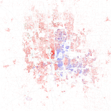
Columbus's Afrikan Amerikan Nüfus büyük ölçüde, Downtown Columbus'un kuzeydoğu ve güneydoğusundaki mahallelerde ve Franklinton ve Yakın Doğu gibi Downtown'ın hemen batısı ve doğusundaki bölgelerde yoğunlaşmıştır. Yerli doğumlu beyazlar ve asimile edilmiş etnik Avrupalılar şehrin her yerine dağılmış durumda, Columbus'un batı yarısındaki mahallelerde ve Downtown'ın hemen güney ve kuzeyindeki bölgelerde daha yüksek yoğunluklar yaşanıyor. Columbus, giderek artan bir İspanyol, Asyalı ve Asyalı Amerikalı ve Afrikalı göçmen nüfusa sahiptir. Columbus'un uzak batı tarafında, özellikle Hilltop'ta, dikkate değer ve çeşitli bir Hispanik nüfus vardır. Meksika kökenli insanlar Hispanik grupların en büyüğü olmak. Ayrıca, çoğunlukla aşağıdakilerden oluşan çok daha küçük bir Hispanik nüfus vardır. Porto Rikolular Northland ve North Linden gibi Kuzeydoğu mahallelerinde de önemli bir Somalili nüfus. Şehrin kuzeybatı kesiminde, Ohio Eyalet Üniversitesi'ne yakın bölgelerde, Hindistan ve Çin'den gelen önemli nüfuslar var.[1]
Columbus Şehir Merkezi
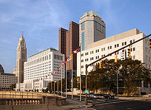


Columbus şehir merkezi, Merkezi İş Bölgesi Columbus, Ohio. Bölge, Geniş ve Ana caddelerin kesişme noktasında merkezlenir ve kuzeydoğu köşeleri, çevredeki işletmeler ve medya tarafından basitçe Geniş ve Yüksek olarak bilinir. Şehir merkezi bir bütün olarak iç kuşak içindeki tüm alanı kapsar ve şehrin çoğuna ev sahipliği yapar. Columbus'daki en büyük binalar. Ohio Statehouse Capitol Meydanı'nda, Broad & High'ın güneydoğu köşesinde yer almaktadır. Şehir merkezinde ayrıca Columbus Eyaleti Topluluk Koleji, Franklin Üniversitesi, Columbus Sanat ve Tasarım Koleji, Grant Tıp Merkezi, Başkent Üniversitesi Hukuk Fakültesi yanı sıra ana şubesi Columbus Metropolitan Kütüphanesi, Ana Cadde Köprüsü ve birçok park. Şehir merkezinde birçok mahalle veya "bölge" vardır, ancak kolayca üç ana alana ayrılabilir: Keşif Bölgesi, High Street Koridoru, ve Nehir kenarı. Kısa Kuzey, İtalyan Köyü, ve Viktorya Köyü doğrudan Downtown'un kuzeyinde. Olde Towne East ve tarihi King-Lincoln Bölgesi doğrudan doğuda iken Brewery Bölgesi ve Alman Köyü doğrudan Downtown'un güneyinde. Franklinton Downtown'ın batısında, Franklinton'un bir kısmı Downtown'da. Kuzeybatı bölgesi, Arena Bölgesi odaklanan karma kullanımlı bir geliştirme Ülke çapında Arena, evi Columbus Mavi Ceketler. Arena District ayrıca beyzbol stadyumunu da içerir Huntington Parkı ve Yaşam Tarzı Topluluklar Pavyonu.
2013 itibariyle, 87.000'den fazla kişi Downtown'da istihdam edilmektedir ve 25.000'den fazla öğrenci, buradaki birçok yüksek öğretim kurumundan birinde okula devam etmektedir.[2] Şehir merkezi şu anda 6,300'den fazla sakine ev sahipliği yapıyor.[3]
Arena Bölgesi
Arena Bölgesi bir karışık kullanım planlı gelişme ve Columbus, Ohio'daki mahalle. Site, Nationwide Realty Investors, Ltd. (bir yan kuruluş olan Ülke çapında ), Columbus Şehri ve özel yatırımcılar. İlçe sınırlarının yorumlanması gelişiyor[4] orijinal 75 dönümlük (300.000 m) etrafındaki komşu bloklar olarak2) site ek ticari ve konut geliştirme gördü. Şu anda, Arena Bölgesi şunları içerir: Ülke çapında Arena ilçenin adını aldığı.
Keşif Bölgesi
Discovery District, şehrin doğu kesiminde yer almaktadır. Columbus Şehir Merkezi. Kuzeyde Interstate 670 Innerbelt, doğuda Interstate 71, güneyde Fulton Street ve batıda Fifth Street ile sınırlanmıştır. Canlı ve ayırt edici kentsel yerleşim bölgesinde, kar amacı gütmeyen ve kültürel kurumlar da dahil olmak üzere Columbus Metropolitan Kütüphanesi, ülkenin en iyi şehir kütüphanelerinden biri olarak derecelendirilen ve Columbus Sanat Müzesi. Diğer bölgesel yerler arasında Fransız Budama sanatı Old Deaf School Park'taki bahçelerin yanı sıra, Columbus Sanat ve Tasarım Koleji, Franklin Üniversitesi, Başkent Üniversitesi Hukuk Fakültesi ve Columbus Eyaleti Topluluk Koleji.
Park Street Bölgesi

Park Street District bir alt mahalledir Arena Bölgesi Columbus, Ohio'da. Bölge, adını çekirdeğinden geçen yoğun bir şekilde ticarete maruz kalan Park Street caddesinden alır.[5] Büyük bir yerleşim alanından yoksun olan semt, ağırlıklı olarak restoran ve barlardan oluşmaktadır. Site, Park Street Kompleksi'nden girişimci Chris Corso da dahil olmak üzere birçok ortak aracılığıyla geliştirildi. Bölge, örtüşen sınırları ve Kuzey Pazarı gibi karşılıklı cazibe merkezleri nedeniyle genellikle Kısa Kuzey'in bir parçası olarak kabul edilir.
River South Bölgesi
Bu alan, Scioto Nehri güneybatıda Columbus Şehir Merkezi. Kuzeyde Town Street, doğuda Wall Street, güneyde Mound Street ve batıda Scioto Nehri ile sınırlanmıştır.
Uptown Bölgesi
Uptown District, Columbus şehir merkezinde bir mahalledir. Kuzeyde Nationwide Boulevard, doğuda South Fourth Street, güneyde East Town Street ve batıda South Front Street ile sınırlanmıştır.
Kısa Kuzey


Short North, Ohio, Columbus'ta, High Street'in ana şeridinde, şehir merkezinin hemen kuzeyindeki ve şehrin hemen güneyine kadar uzanan bir mahalledir. Ohio Devlet Üniversitesi kampüs alanı. Kongre merkezine kolay bir yürüyüş mesafesindedir veya Ülke çapında Arena kuzeyde bölge. Short North, özellikle aylık "Gallery Hop" ve diğer yerel ve şehir merkezindeki etkinlikler sırasında, genellikle hafta sonları kalabalık olur.
Short North, yoğun bir şekilde Sanat galerileri, özel mağazalar, barlar, gece kulüpleri, ve kahvehaneler. Sıkıca paketlenmiş tuğla binalarının çoğu, High Street boyunca geleneksel vitrinler (genellikle yan duvarlarında parlak boyalı duvar resimleri ile) ve eski apartman binaları ile en azından 20. yüzyılın başlarından kalmadır. Sıra evleri ve daha yeni kat mülkiyeti çevredeki bloklardaki gelişmeler. Şehir, 1900'lerin başında bölgede bulunan bu tür kemerleri anımsatan, Kısa Kuzey boyunca High Street boyunca uzanan 17 ışıklı metal kemer kurdu.
Bölge aynı zamanda çok eşcinsel ve lezbiyen dost canlısı mahalle ve birçok gey gece kulübü ve bar bölgede bulunur ve yıllık Columbus gay'in yeridir. gurur geçit töreni.
İtalyan Köyü
Italian Village, Ohio, Columbus'ta bir dizi konut, ticari ve endüstriyel bina içeren karma arazi kullanımlı bir mahalledir. Tarihi ve kültürel koruması ile tanınan belirlenmiş tarihi bir bölgedir. Bina türleri ve mimarisi İtalyan etkisini yansıtır. Parkları ve korunmuş tarihi evleri ile Italian Village, Columbus'taki en yüksek ev değeri değerine sahiptir.Italian Village, Short North bölgesinin bir parçasıdır. Komşu Downtown Bölgesi, büyük işverenlere, kültür ve öğrenim kurumlarına ve eğlence mekanlarına erişim sağlar.
Viktorya Köyü
Victorian Village, kuzeyde ve batısında yer alan bir mahalledir. Şehir merkezi. Kentsel bir ortam için oldukça fazla sayıda kurulu ağacın bulunduğu eski bir alandır. Neil Avenue, kuzey-güney yönünde uzanan ve sonunda The kampüsünden geçen bir cadde. Ohio Devlet Üniversitesi, ana caddesidir.
Güney Yakası ve Güney Doğu


Brewery Bölgesi
Brewery District, Columbus, Ohio'da bulunan bir mahalledir. Merkezi ticaret bölgesinin hemen güneyinde yer alan bölge, yaklaşık 200 yıllık bir geçmişe sahiptir. İle sınırlandırılmıştır Eyaletlerarası 70 kuzeyde Güney Pearl Caddesi, güneyde Greenlawn Caddesi ve Scioto Nehri batıda. İlk bira fabrikası 1836'da Alman göçmen Louis Hoster tarafından açıldı.[6] Başarısının zirvesinde, bölgede beş bira fabrikası vardı. Yıllar geçtikçe bira fabrikalarının konsolidasyonu gerçekleşti. Ancak, 1920'de piyasa güneye gitti. Yasak geçiş nedeniyle yürürlüğe girdi 18. Değişiklik. Alan geriledi, bazı endüstri ve depolara ev sahipliği yaptı. Son yıllarda, bölgeye gelen çok sayıda restoran, bar ve hatta bir bakkal ile büyük ölçekte yeniden yapılanma gerçekleşti. Radyo istasyonu CD 101, şimdi CD102.5, ilçeyi de ev arıyor. Alman-Amerikan Şarkı ve Spor Topluluğu olan Germania Club, 1866'dan beri bölgede bulunuyor ve 1927'de mahallenin prestijli bira ustalarından biri olan Nicolaus Schlee'nin eski evini kulüp tarafından kullanılmak üzere satın aldı.
Alman Köyü
Alman Köyü, şehrin hemen güneyinde tarihi bir mahalledir. şehir merkezi. 19. yüzyılın ortalarında, bir zamanlar tüm şehrin nüfusunun üçte birini oluşturan çok sayıda Alman göçmen tarafından yerleştirildi. Çoğunlukla yerel olarak sahip olunan restoranların yanı sıra yüksek çan kulelerinin bulunduğu South Third Street boyunca ortalanmış ticari bir şeridi vardır. St. Mary Katolik Kilisesi. Bölge çoğunlukla ağaçlarla kaplı, tuğla döşeli sokaklar boyunca dövme demir çitlere sahip sağlam, kırmızı tuğlalı evlerden oluşan bir yerleşim bölgesidir. Güney ucunda, adını Schiller Park Friedrich von Schiller, bir zamanlar Alman yerleşimi için bir topluluk buluşma yeriydi. Şimdi, Actor's Theatre'ın izniyle yaz aylarında Shakespeare oyunlarının ücretsiz canlı performanslarına ev sahipliği yapan rekreasyon tesisleri, bahçeler ve bir amfitiyatro alanıdır.
Livingston Avenue Bölge Komisyonu
Sürüş Parkı
Driving Park, üzerinde kentsel bir yerleşim alanıdır. Yakın Doğu Yakası. Interstate 70'in hemen güneyinde, Livingston Park da dahil olmak üzere birçok önemli bölgeye komşudur. Old Oaks Tarihi Bölgesi ve Bryden Road Historic District, hepsi Columbus'un ilk tramvay banliyölerinden birinin bir parçası olan önemli Livingston Avenue Corridor'un ortak şeridine sahip. Mahalleye atıfta bulunulduğunda, sınırları genellikle kuzeyde Mooberry Caddesi, doğuda Alum Creek Caddesi, güneyde East Whittier Caddesi ve batıda Miller Caddesi'nden oluşmaktadır. Sürüş Parkı Alanı Komisyonu, mahallenin sınırlarını I-70 kuzeyde N&W Demiryolu, güneyde East Whittier Caddesi ve batıda Lockbourne Caddesi. Daha fazla referans, topluluğu doğrudan arasına yerleştirir Bexley ve Alman Köyü.
Eski Meşeler
Old Oaks, Downtown Columbus'un hemen doğusunda bulunan tarihi bir bölgedir. Mahalle kuzeyde Mooberry Caddesi, doğuda Kimball Place'deki evler, güneyde East Livingston Bulvarı ve batıda South Ohio Caddesi'ndeki evlerle sınırlanmıştır.
Livingston Park, Bryden Road Historic District ve Sürüş Parkı hepsi de Columbus'un ilk tramvay banliyölerinden birinin parçası olan Livingston Avenue Corridor'un ortak noktasında.
Mimari tarzlar arasında American Foursquare in Mission ve Neoclassical Revival stillerinin yanı sıra Modified Queen Anne's bulunmaktadır.
Livingston Parkı
Livingston Park, adını Columbus Şehri'nin sahip olduğu en eski park alanıyla paylaşan bir mahalledir.[7] 3. ile sınırlıdır. St. (Batı), Livingston Ave. (Güney), Mooberry Caddesi (Kuzey) ve Ohio Ave (Doğu).[8] Yerleşim alanı büyük ölçüde Mooberry St. ve Livingston Ave arasındaki Carpenter, Gilbert, S. 22. ve Ohio Sokaklarından oluşmaktadır. 18'in batısındaki ticari alanlar, Ulusal Çocuk Hastanesi.
Güney Yakası Bölge Komisyonu
Deshler Parkı
Kuzeyde East Whittier Caddesi, doğuda Fairwood Bulvarı veya Alum Creek Yolu, güneyde Moler Yolu veya Frebis Caddesi ve batıda Lockbourne Yolu ile sınırlıdır.
Edgewood Acres
Edgewood Acres, kuzeyde Thurman Caddesi, doğuda Lockbourne Yolu, güneyde Frebis Caddesi ve batıda Güney Champion Caddesi ile sınırlanmıştır. Hemen doğusunda Lincoln Parkı.
Macar Köyü

Hungarian Village, Güney High Street ve Parsons Avenue arasındaki Woodrow ve Hinman Caddeleri arasındaki alanı kapsayan, Merion Village ile Reeb-Hosack / Steelton Village arasında, Columbus şehir merkezinin güneyinde bir mahalledir. 20. yüzyılın başında bölge, Macarca, Hırvat, ve İtalyan göçmenler ve daha sonra, başarısızlardan kaçan mülteciler Macar Devrimi 1956.
Innis Gardens
Bu alan kuzeyde Moler Yolu, doğuda Fairwood Bulvarı, güneyde Innis Caddesi ve batıda Lockbourne Yolu ile sınırlanmıştır. Hemen doğusunda Edgewood.
Lincoln Parkı / Vassor Köyü
Bu alan kuzeyde Frebis Caddesi, doğuda Güney Champion Bulvarı, güneyde Woodrow Bulvarı ve batıda Parsons Bulvarı ile sınırlanmıştır.
Merion Köyü
Hemen güneyinde Alman Köyü Merion Köyü, çoğunlukla 20. yüzyılın başlarından kalma evlerin bulunduğu bir mahalle. Yenileyenler boş evlerin çoğunu tamir ediyor. Suç gözlemciye yardımcı olmak için 2020'de iki yeni polis devriyesi eklendi ve Shot Tracer teknolojisi şu anda güneyde kullanılıyor.
Millbrook
Bu alan kuzeyde Moler Road, güneyde Universal Road, doğuda Progress Road ve batıda Fairwood Avenue ile sınırlanmıştır. Hemen doğusunda Innis Gardens.
Reeb-Hosack
Bu, şehrin güney tarafındaki Reeb Caddesi ile Hosack Caddesi arasındaki bölgedir. Güney High Street ve Parsons Avenue ile batı ve doğu uçlarında sınırlanmıştır.
Schumacher Yeri
Bu, Alman Köyü'nün doğusunda bulunan küçük bir alandır ve çoğu zaman bunun bir parçası olarak karıştırılır. Kuzeyde East Livingston Caddesi, doğuda Parsons Caddesi, güneyde East Whittier Caddesi ve batıda Lathrop Caddesi, Brust Caddesi, South Grant Caddesi ve Jaeger Caddesi ile sınırlanmıştır.[9]
Steelton Köyü
Swaynes Ekleme / Güney Meyve Bahçeleri
Southern Orchards, Ohio, Columbus'un yakın güney tarafında, şehir merkezinin hemen dışında bulunan yerleşik bir mahalledir. Columbus'un en yürünebilir 23. mahallesi ve 3.538 sakini var.[10] Mahalle, büyük ölçüde çapa kurumu nedeniyle canlanma ve güzelleştirme hedefi. Ulusal Çocuk Hastanesi.[11] ve şehrin merkezinde kentsel yaşama olan ilginin yenilenmesi. 2008 yılından bu yana, hastanenin Sağlıklı Evler programı aracılığıyla 70'den fazla mülk iyileştirildi ve şehir, şehir merkezini çevreleyen mahallelere yeniden bağlamak için hareket ederken Livingston ve Parsons'ın ana caddelerinde sürekli canlandırma gerçekleşiyor.[12]
Thurman Meydanı
Bu alan, Güney Meyve Bahçelerinin güneyinde ve Vassor Köyü'nün kuzeyinde ve kuzeyde Whittier Caddesi, doğuda Lockbourne, güneyde Frebis Caddesi ve batıda Parsons Caddesi ile sınırlanmıştır. Mahalle içindeki sivil ve blok saatler arasında Thurman Meydanı, Ganthers Place, South Central Commons ve Edgewood bulunmaktadır.
Doğu tarafı

Doğu Yakası, Ohio, Columbus'un doğu tarafında birkaç tarihi mahalleden oluşan bir bölgedir. Bölgeyi oluşturan bazı mahalleler şunlardır: Beatty Park, Bronzeville / King-Lincoln, Eastgate, Franklin Parkı, Mt. Vernon Avenue Bölgesi, Nelson Parkı, Olde Towne East ve Woodland Park. Bugün kuzeyde Norfolk Güney demiryolu ile sınırlanmıştır. Şap Deresi doğuda Eyaletlerarası 70 ve güneyde Livingston Bulvarı ve Eyaletlerarası 71 batıda.[13] Ana Cadde olarak da ikiye bölünmüştür. Ulusal yol. Bu bölge Bölgenin 6, 12 ve 5.Bölgelerindedir. Columbus Polis Bölümü
East Broad Street Tarihi Bölgesi
East Broad Street Historic District, 1987'de Ulusal Tarihi Yerler Sicilinde listelenen tarihi bir bölgedir. Batıda Ohio Bulvarı'ndan doğuda Monypenny Caddesi'ne kadar Doğu Broad Caddesi'nin bölümünü içerir.
Eastgate ve Nelson Parkı
1916'da geliştirilen Eastgate mahallesi Nelson Park, Eastgate İlköğretim Okulu ve East Broad Street ile Nelson Road'un kesişme noktasını içerir. Yaygın olarak hem Eastgate hem de Nelson Park olarak anılır[14]
Franklin Parkı
Bu mahalle kuzeyde East Broad Street, doğuda Alum Creek, güneyde East Main Street ve batıda Wilson Avenue ile sınırlanmıştır. Mahalleleri ile çevrilidir Woodland Parkı, Main'in güneyinde ve Olde Towne East ve şehir Bexley. Semt, adını 88 dönümlük parktan alıyor. Hem mahalle hem de simgesel park, Franklin Park Konservatuarı ve Botanik Bahçeleri, parkın adını da almıştır.
King-Lincoln Bronzeville
Hemen doğusunda Columbus Şehir Merkezi bu alan, Vernon Dağı kuzeyde mahalle ve Atcheson Caddesi, doğuda Kuzey 20.Sokak, Olde Towne East güneyde East Broad Street ve batıda I-71. Alan bir zamanlar çok daha büyüktü ve şu anki Keşif Bölgesi. I-71'in oluşturulması, bölgeyi Downtown'dan önemli ölçüde keserek sosyoekonomik düşüşe ve suç ve şiddetin büyümesine neden oldu. Mahalle, şehrin yeniden canlandırma çabalarının odak noktası haline geldi. Lincoln Tiyatrosu, yeni apartmanların inşası ve Mt. Yıllık Long Street Tour bisiklet etkinliğine ev sahipliği yapan Vernon Caddesi ve East Long Street.
Vernon Dağı veya Beatty Parkı
Vernon Dağı, tarihi Yakın Doğu Yakası topluluk. 71 ve 670 arası eyaletlerle sınır komşusudur. Ana caddeleri, Mount Vernon Caddesi, East Long Caddesi, Atcheson Caddesi ve Champion Caddesi, topluluğun sınırlarını belirler.
Olde Towne East
Olde Towne East, tarihi bölgede bulunan bir mahalledir. Yakın Doğu Yakası. Bugün "Olde Towne East" olarak bilinen mahalle, Columbus'un tarihinde erken yerleşmiş ve Şehir merkezi Pazar ve Keşif Bölgeleri, Franklin Parkı, King-Lincoln Bronzeville, Livingston Park North ve Eski Meşeler. Bölgede bazıları 1830'lar kadar eski 1.000'den fazla ev ve aşağıdakiler dahil 50'den fazla mimari tarz bulunmaktadır. İtalyan, Kraliçe Anne ve Viktorya dönemi.
Main'in güneyinde
Main'in güneyinde bulunan bir mahalle Yakın Doğu Yakası. Kuzeyde Ana Cadde, doğuda Alum Deresi, güneyde I-70 ve batıda Wilson Caddesi ile sınırlanmıştır.
Woodland Parkı
Woodland Park, kuzeyde Maryland Bulvarı, doğuda Nelson Yolu, güneyde Doğu Broad Caddesi ve batıda Taylor Caddesi ile çevrili Columbus, Ohio'da bir mahalledir.
Alt bölümdeki en eski evler 1900'lerde inşa edildi ve o zamandan 1920'ye kadar bölgeyi en çok doldurdu. 26 Haziran 1904 Pazar günü elle çizilmiş bir haritayla büyük bir reklam çıktı. Columbus Dispatch Woodland Park İlavesinin faydalarını anlatan gazete. "Size asfalt sokaklar, çimento kaldırımlar, su, gaz, kanalizasyon, elektrik lambaları, bol miktarda ince orman ağacı ve şehrin en iyi okul bölgelerinden birini veriyoruz. Woodland Park Addition, üç elektrikli araba hattı avantajına sahiptir. High Street'e on beş dakika içinde ulaşabilirsiniz. "
Sakinleri Woodland Park Mahalle Derneği'ni kurdu. Web sitelerinde şöyle yazıyor: "Woodland Park, Columbus'un ilk planlanan, lüks banliyö mahallelerinden biri olarak yirminci yüzyılın başında kuruldu. Woodland Park," Franklin Park'a Kuzey Geçidi "olarak anılıyordu ve hızla Columbus'un kurucu ailelerinin yanı sıra girişimciler, iş sahipleri, sanayiciler, eğitimciler ve sanatçılar… Ulusal olarak tanınan sanatçı Emerson Burkhart da dahil olmak üzere, Columbus'un çok sayıda önde gelen vatandaşı Woodland Park'ı evi olarak adlandırdı.
Mahalle, Colonial, Federal, Arts and Crafts, Victoria, Tudor, Mission, Dutch Colonial, Colonial Revival, Greek Revival, Georgian Colonial, French Eclectic, American Foursquare ve Cape Cod gibi seçkin mimarinin eklektik bir karışımına ev sahipliği yapmaktadır. Mahalle, büyük konaklardan bungalovlara ve çatı katlarından stüdyo dairelere kadar değişen büyüklükte evler, şehir evleri ve dairelerden oluşmaktadır. Bu çeşitli ev karışımı, Woodland Park'ı yaşamak için rahat, uygun fiyatlı ve çekici bir mahalle yapıyor. "[kaynak belirtilmeli ]
Clintonville


Clintonville, 2011 yılı itibariyle yaklaşık 30.000 nüfusu olan Ohio, Columbus'un kuzey merkezinde bir mahalledir.[15] Clintonville gayri resmi bir mahalledir. Güney sınırı, genel anlamda Arcadia Bulvarı veya Glen Echo Geçidi olarak tanımlanmıştır. Doğuya da Eyaletlerarası 71 veya bitişik demiryolu rayları genel olarak kabul edilir. Batı sınırının, Olentangy Nehri. Clintonville'in kuzey sınırı, Cooke Yolu'ndan güney sınırına kadar 3 mil (4,8 km) boyunca herhangi bir yerde tanımlarla en belirsiz olanıdır. Worthington. Columbus Şehir Kodu tarafından belirlenen Clintonville Bölge Komisyonu sınırları, "güneyde Glen Echo Uçurumunun merkez hattıyla; doğuda Indianola Bulvarı'nın hemen doğusunda demiryolunun merkez hattıyla sınırlanmıştır; kuzeyde Worthington şehir sınırları ve batıda Olentangy Nehri ile; her hat, bitişik sınırlarla kesişecek şekilde gerektiği kadar uzanıyordu ".[16]
Clintonville mahallesinin kaşesi 21'inci yüzyılın başlarına doğru büyüdükçe, emlakçılar Cooke Road'un kuzeyindeki evleri Clintonville'de olarak etiketlemeye başladılar, bu da Beechwold'un ve güneydeki civardaki mahallelerin görünür şekilde emilmesine yol açtı Worthington. 2000'li yıllarda patlayan emlak piyasasında, farklı doğu ve batı sınırlarının dışındaki evlerin "Clintonville" evleri olarak satılması nadir değildi. Clintonville ve Beechwold'un resmi bir varlıkları olmadığı için, sınırlar bir fikir meselesidir. Bölge ayrıca, eski tüzel kişiliğe sahip olmayan Evanston topluluğunu da içerir. Büyük Dört Demiryolu 1920'lere kadar hattı ve ABD Posta servisi boyunca bir istasyon olarak. Clintonville, Posta kodları 43202 ve 43214. The Amerika Birleşik Devletleri Postaneleri Her bir posta kodunun merkezinde sırasıyla Clintonville İstasyonu ve Beechwold İstasyonu olarak bilinir.
Mahallelerin belirsiz sınırlarına rağmen, sınırlar dört ayrı mahalleye genelleştirilmiştir: South Clintonville, North Clintonville, Beechwold ve North-of-Morse.
Güney Clintonville
Kuzey Broadway Caddesi'nin güneyinde, konut stoğu, tek ve çok aileli evlerin bir karışımıdır. Bu evlerin çoğu 1930'dan önce inşa edilmiş ve temel Amerikan dört köşesinden diğer canlanma tarzı mimariye kadar çeşitli stilleri temsil ediyor. Bölge ayrıca birçok katalog (Sears, Montgomery Ward, Radford, vb.) Kit evlerine ev sahipliği yapmaktadır. Bu mahalleler başlangıçta "tramvay" olarak da geliştirildi; amaç, çoğu sakinlerin Columbus şehir merkezine gitmek için High Street tramvay hatlarına güvenmesiydi. En eski gelişmiş caddelerin garajlarına mülklerin arkasındaki sokaklardan erişilir.
Kuzey Clintonville
Kuzey Clintonville, Clintonville mahallesinin içindeki genelleştirilmiş bir alandır. Sınırları ya eski Columbus Şehir Sınırlarına ya da daha modern bir şekilde Kuzey Broadway'e dayanmaktadır. Eski Columbus Şehri sınırına göre: kuzeyde Overbrook Ravine, Büyük dört doğuya doğru demiryolu rayları, güneyde Orchard Lane ve kabaca Oakland Park Bulvarı ve Olentangy Nehri batıya doğru. Modern yoruma göre: Kuzeyde Overbrook Geçidi, güneyde Kuzey Broadway Caddesi ve batıda Olentangy Nehri. Genellikle North Clintonville olarak anılırken, Clintonville bölgesinin merkezi bölümüdür. 1920'lerden 1950'lerin sonlarına kadar mimari tarzlarda ve yaşam tarzı düşüncelerindeki ilerlemeyle dikkat çekiyor. Clintonville'in bu bölümündeki evler daha üst düzey mülkler olarak inşa edildi, ara yollardan yoksun ve otomobilin rolünün artan önemine bir selam olarak garaj yolları içeriyor. Bu bölgede bulunan gelişmeler ve alt bölümler şunlardır: Indian Springs, Northridge, Dominion Park, Northmoor, Brevoort Place, North Broadway Street ve Woodland Crest.
Beechwold
Beechwold, Clintonville Bölge Komisyonu sınırları içinde yer alan bir mahalledir. North High Street'teki Jeffrey ailesinin yazlık arazisi ve Clintonville'in büyümesinin ardından bölgeye yerleştirilen postane için adlandırılan daha büyük Beechwold Bölgesi, büyük ölçüde farklı tanımlara sahiptir, ancak en azından en az dört alt bölümden oluşan bir koleksiyondur. Bu dört platform şunlardır: Beechwold (1915), Beechwold Addition (1919), Beechwold South (1902) ve Beechwold South Amendment (1922). Yaygın olarak bilinen Doğu Beechwold bölümü, Zooland ve Highland Gardens'ın alt bölümlerini içerir. Doğu Beechwold'un dahil edilmesiyle, daha büyük Beechwold alanı, daha sonra gevşek bir şekilde kuzeyde Rathbone Caddesi, doğuda I-71, güneyde West Weisheimer Yolu ve batıda Olentangy Nehri olarak tanımlanır.
Northwold
Northwold, Graceland Center ile Homedale Addition alt bölümü arasında bir hayalet mahalledir. Northwold'un karşısındaki ana cadde Fenway Yolu'ydu ve mahalle 1933'te terk edildi.[17]
Eski Beechwold
Old Beechwold 1987'de Ulusal Tarihi Yerler Siciline yerleştirildi ve North High Street'teki orijinal Jeffrey ailesinin yazlık arazisinde yatıyor. Ulusal Kayıt'taki girişe göre sınırları, kuzeyde West Jeffrey Place, doğuda North High Street, güneyde River Park Drive ve batıda Olentangy Boulevard ile sınırlandırılmıştır. Bu açıklama, Beechwold (1915) ve Beechwold Addition (1919) alt bölümlerini içeren tarihi haritalara uyar.
Doğu Beechwold
Doğu Beechwold, Zooland (1905) ve Highland Gardens (1913, 1915) alt bölümlerinden oluşur ve bu nedenle kuzeyde Morse Yolu, doğuda I-71, güneyde Weisheimer Yolu ve batıda Kuzey Yüksek Caddesi ile sınırlanmıştır. .
Güney Beechwold
South Beechwold, Beechwold South (1902/1922) ve Weisheimer Addition No. 2 alt bölümlerinden oluşur. Bu nedenle, kuzeyde Beaumont Bulvarı'nın kuzeyinde, kuzeyde Kuzey Yüksek Caddesi, güneyde Weisheimer Yolu ve batıda Olentangy Nehri ile sınırlanmıştır. High Street'te bulunan işletmelerin istisnaları dışında, neredeyse tamamen konut niteliğindedir.
Kuzey-Mors
North-of-Morse, Clintonville'in en kuzeydeki bölümüdür. Kuzeyde Mezarlık ve Chase yollarında Worthington şehir sınırları, doğuda I-71, güneyde Morse Yolu ve batıda Olentangy Nehri ile sınır komşusudur. Graceland Alışveriş Merkezi'nin yanı sıra diğer konut evlerini içerir.
Güneybatı
Briggsdale
Briggsdale, batı / güneybatı tarafında bir mahalledir. Tüm Briggs Yolu boyunca uzanır ve Briggs Yolu, doğu ve batı Eakin Yolu ve Harrisburd Pike ve Demorest Rd kuzey ve güney ile sınırlanan tüm alan olarak tanımlanabilir. Güney bölgesi Hilltop kuzey-güneybatı tarafı.
Batı Yakası
Batı Yakası içerir:
Franklinton

Franklinton, Scioto Nehri kuzeyde ve doğuda, doğuda Harmon Caddesi, güneyde Stimmel Yolu ve Greenlawn Bulvarı ve Eyaletlerarası 70 batıda.[18] West Broad Street veya U.S. Route 40, ülkenin ilk yollarından biridir ve Franklinton'un ana yoludur. Downtown'ın hemen batısındaki mahalledir. Mahallenin bir kısmının renkli takma adı "Dipler "çünkü arazinin çoğu Scioto ve Olentangy nehirlerinin seviyesinin altında yer alıyor ve nehirleri kontrol altına almak ve bölgeyi yıkıcı sellerden korumak için bir taşkın duvarı gerekiyor. Franklinton'un hemen batısında, genellikle adı verilen bir grup küçük mahalle var. "Hilltop."
Franklinton bölgeleri arasında South Franklinton ve East Franklinton bulunur.
Hilltop ve Greater Hilltop


Hilltop, şehrin batı tarafındaki coğrafi bir alandır. Bu şekilde adlandırıldı çünkü Scioto Nehri'ne doğru inen bir yükselmenin üzerinde oturuyor. Highland West, Wilshire Heights ve Westgate Greater Hilltop alanı içinde yer almaktadır. Franklinton sınırında. "Greater Hilltop Area" (Columbus şehri tarafından tanımlandığı şekliyle) kuzeyde Interstate 70, doğu ve güneyde B&O Railroad ve güney ve batıda Interstate 270 dış kuşak ile sınırlanmıştır.[19] Ana caddeleri West Broad Street'tir (ABD Route 40) - üzerinde mahalle için iki karşılama tabelası (biri I-70 yakınında ve diğeri Wilson Yolu yakınında) - Mound Caddesi ve Hague Caddesi.
Greater Hilltop bölgesi daha yeni ve tarihi mahalleler, okullar, çeşitli mağazalar, endüstriyel alanlar ve dinlenme tesisleri içerir. Geliştirme modeli ayrı bir banliyö olarak kabul edilir. Bölgenin çoğunluğu, ağırlıklı olarak tek aileli konutlardır.[20]
Greater Hilltop
- Brookshire
Brookshire, Briggs Road'dan Binns Bulvarı'na, Eakin Road'dan Eureka Bulvarı'na kadar uzanan topluluktur. Brookshire, 1969'dan 1985'e kadar 16 yıl boyunca 13 şampiyonlukla bir beyzbol Küçükler Ligi güç eviydi. Power Lifting Batı Yakası'nda doğdu ve Beyzbol kraldı.
- Holly Hill
Holly Hill, Batı Columbus, Columbus, Ohio. Holly Hill, çoğunlukla tuğla çiftlik evleri ve bazı iki katlı evlerden oluşan 1960'ların geleneksel bir banliyö mahallesidir. Evlerin büyüklükleri yaklaşık 860 fit kare (80 m21.500 fit kareye kadar (140 m2). Holly Hill yanında yer almaktadır Gürcü Tepeleri.
- Highland West
Adını 1800'lerin sonlarında bu bölgeye hizmet veren hat sonu sokak arabasından alan Highland West, West Columbus'un Hilltop bölgesinin orijinal yerleşim yeri veya tarihi, daha eski bölümüdür. 1800'lerin başlarından ortalarına. Tepenin bu bölgesine ilk yerleşimciler İngiliz, Galce ve Afrika kökenli Amerikalılar idi. Highland West kuzeyde demiryolu rayları (Columbus / Valleyview şirket hattının hemen güneyinde), doğuda I-70 ve Franklinton (The Bottoms), güneyde Sullivant Bulvarı ve batıda Lahey ile sınırlanmıştır. Bulvar. Highland West, National Road, Glenwood Heights, Maple Grove, Buckingham Heights, Westwood Heights, Oakley, Arlington, Highland Park, Bellaire, Bronx, Eldon Heights, Glenview Heights, Hillcrest Park, High Park'ı çevreleyen orijinal mahallelerin bir koleksiyonudur. Peyzaj Ekleme, Florence Park ve Wicklow.
- Gürcü Yüksekliği
Georgian Heights komşuları Holly Hill. İkisi, kuzeyde Sullivant Caddesi, doğuda Demorest Yolu, güneyde Clime Yolu ve batıda Georgesville Yolu ile birbirine bağlanmıştır. Georgian Heights'ın Georgian Heights Packers adında bir genç seyahat futbol takımı var. Mahalle genellikle alt-orta sınıftır.
- Nehir kıvrımı

Riverbend, güneybatı Columbus, Ohio'da bir mahalledir. Riverbend, 1970'lerin ortalarına kadar 1968 civarında inşaat yapmaya başladı. İşçi sınıfı bir mahalleydi. Çocuklar, Riverbend Park'ta basketbol, beyzbol ve softbol oynamanın yanı sıra yerel dere ve ormanda oynadılar ve kazanan takım, galibiyetlerini kutlamak için kornalarını çalarak mahallede dolaştılar. Yakınlarda iki yaz havuzu vardı, Moose Lodge ve Wee Bonnie (ikincisi artık yok). Wee Bonnie olarak da adlandırılan dokuz delikli bir golf sahası havuzun bitişiğindeydi ve o da yok. Orada yaşayan öğrencilerin çoğu Franklin Heights Lisesine devam ediyor. Riverbend, artık birçoğunun kiraya verildiği ve topluluk duygusunu yitiren yaşlanan evler nedeniyle düşüşe geçti.
- Westgate

Westgate, içinde bir topluluktur Hilltop Columbus bölgesi, Ohio. Kısmen daha önce konutun bulunduğu arazi üzerine inşa edilmiştir. Amerikan İç Savaşı Kamp Chase ve Konfederasyon hapishane. İç Savaştan sonra arazi, Joseph Binns ve ortakları tarafından bir savaş başlatmak için satın alındı. Menonit topluluk. Bu planlar hayata geçirilemedi ve arazi "tramvay banliyösü "1920'lerde. Downtown'ın 4 mil (6,4 km) batısında bulunan mahalle, aynı zamanda Westgate Park ve Dinlenme Merkezi, Westgate Alternatif İlköğretim Okulu, St. Mary Magdalene Kilisesi ve okulu ve Parkview United Metodist Kilisesi'ne de ev sahipliği yapmaktadır. Yakın bölge Westgate, Hilltop şubesine ev sahipliği yapmaktadır. Columbus Metropolitan Kütüphanesi, Batı Lisesi ve Camp Chase Confederate Mezarlığı. Westgate sınırları içinde 2,100 hanede yaklaşık 4,500 kişi yaşamaktadır. Sınırlar kuzeyde West Broad Caddesi, doğuda Roys Caddesi, güneyde Sullivant Caddesi ve batıda Demorest Yolu'dur.
- Wilshire Heights
Wilshire Heights'ın güneyinde Westgate Kuzey sınırı Sullivant Caddesi, doğuda Harris Caddesi, güneyde Briggs Yolu, batıda Salisbury Yolu. Westgate'e hem kültürel hem de mimari açıdan çok benziyor.
- Diğer alanlar
Diğer alanlar arasında Broad Lawn, Southwest Hilltop, Moneyback, Valleyview ve Valleyview Heights bulunmaktadır.
Westland
Lincoln Köyü
Nerenin hemen doğusunda Yeni Roma eskiden, burası West Broad Street'in kuzeyindeki bölgedir. Doktor Hastanesi Batıdan Interstate 270 dış kuşağına. Bu, nüfus sayımı tarafından belirlenmiş bir yerdir (CDP) Prairie Township.
Murray Hill
Genellikle dahil Cherry Creek Murray Hill, bir mahallede bir caddedir. Batı Yakası. Bu parçası Lincoln Köyü subdivision and is colloquially known as Lincoln Village. It is bounded by West Broad Street on the north, Sullivant Avenue on the south, South Grener Avenue on the east, and Redmond and Hiler roads on the west.
Far West neighborhoods
Cherry Creek
Cherry Creek is a neighborhood on the West Side. It contains the Lincoln Park and Westview apartment complexes. It is bounded on the east by the Interstate 270 Outerbelt, on the north by Sullivant Avenue, on the west by Norton Road, and on the south by Hall Road.
Hardesty Heights
Hardesty Heights is located in the West Side, and the most western part of the neighborhood is also the city limits. Its eastern border is Norton Road and it is directly across from Cherry Creek. The neighborhood consists of townhouse-type condominiums, which all have carports. It is in Precinct 10 of the Columbus Polis Departmanı. They have their own security along with CPD Patrol.
Lincoln Köyü
Lincoln Village is a neighborhood located on the West Side of Columbus, Ohio and is known for its long history and historical impacts it has had on the surrounding communities. Most of the residential real estate is occupied by a mixture of owners and renters. Residents in this area tend to be older and well committed to this area. Homes were typically built between 1940 and 1969, while many others were built between 1970 and 1999. Those who built and live in these homes contain a unique mix of cultural or occupational groups.
Lincoln Village was founded in 1955 as a planlanmış topluluk by a real estate subsidiary of Ülke Çapında Sigorta.[kaynak belirtilmeli ] The community was developed to have all the essentials such as a shopping center, schools, and parks, and to incorporate safety considerations such as not positioning the homes on street corners to eliminate blind intersections.
Northside and Northwest

Northwest Columbus is a geographic region located in the northwest region of Franklin County, Ohio. The Northwest Civic Association, founded in 1967, acts as the commission of this area. It is bounded by the Scioto River on the west, the Olentangy River on the east, State Route 161 on the north, and Highland Drive and Henderson Road on the south. Northwest Columbus includes parts of Perry Township and Sharon Township, the City of Dublin, and the City of Worthington.[21] Slightly more than 45,000 citizens live within this area according to the 2010 U.S. census.[22]
The North Side
Brookhollow
Flytown
Flytown was a neighborhood just northwest of downtown Columbus, encompassing portions of the present-day Arena District and western sections of the Victorian Village. In the 19th century, it was considered the center of the Irish-American community in the city after the arrival of immigrants fleeing the Great Famine, and Naughten Street, now Nationwide Boulevard, was nicknamed the "Irish Broadway." It is currently the location of the Thurbergate neighborhood, which has been incorporated into Harrison West.
Highland-McCoy
Highland-McCoy is less of a neighborhood than it is a rural-styled area in the midst of suburban development. It is considered the zone along Highland Drive, between Kendale and Knolls to the north, with Upper Arlington, Greenfield Estates and Thomas (not to be confused with Thomas Lane güneye).
Northcrest
Northcrest is a neighborhood on the northwest side of the city. It is bounded by Bethel Road on the north, Reed Road on the east, West Henderson Road on the south, and Woodrun Boulevard on the west.
Değirmen Çalıştırması
Linworth
Linworth is the historical name for the area in and around the intersection of State Route 161 and Linworth Road, bordered on the west by Brookside Estates and the OSU airport and on the east by State Route 315. The area received its name due to its location, between Dublin (dub-lin) ve Worthington (değer-ington). The west part of Linworth is now in Columbus, and the east part (home to the Linworth Alternative Program school ) is in Worthington.
Olentangy
Olentangy is a neighborhood that takes its name from the Olentangy Nehri. Also called West Olentangy and Olentangy River Road, it is generally bordered by West North Broadway Street on the north, the Olentangy River on the east, West Lane Avenue on the south, and Yukarı Arlington batıda.
Olentangy Commons

Olentangy Commons is a planlı gelişme yerleşim bölgesi[23][başarısız doğrulama ] which is located in northwest Columbus, Ohio. The nearby areas surrounding the original 65-acre (263,045 square meters) site of the Olentangy Commons Apartments have been developed into commercial and residential neighborhoods.[kaynak belirtilmeli ]
Seagrave
This was a small area centered on the intersection of West Lane Avenue and Kenny Road on what is now the West Campus of The Ohio State University. Although much of the neighborhood was demolished to make way for Devlet Yolu 315, a few buildings remain, including the ruins of the Laneview School.
San Margherita
San Margherita is an unincorporated neighborhood that may be in danger of vanishing. Though most of the locally owned businesses in the neighborhood have been demolished to make way for widening roads and commercial development, the remaining houses in San Margherita still retain their original character. Most of the simple homes sit on an acre (4,000 m2) of land, giving it a somewhat rural feeling, and backyard vineyards planted by the original residents are still maintained today.
Harrison West

Harrison West is a historic, urban neighborhood located north and near west of downtown Columbus, Ohio. The neighborhood character is similar to the better-known Viktorya Köyü sadece doğuya. The area is bounded by Harrison Avenue on the east (which runs parallel to Neil Avenue), Goodale on the South, 5th Avenue on the North, and Olentangy River Road to the west (including "Gowdy Field"). In January 2008, the neighborhood expanded to include all of "Thurber Village" to the south east.
Developed from the Neil Farm in the early 20th century, Harrison West is characterized by Viktorya dönemi ve Edwardian -style homes, although the housing stock is generally more modest than the grand homes found in Victorian Village proper. Frame houses are more common than brick.
The Harrison West neighborhood area experienced urban decline throughout much of the late 20th century. Just south of Harrison West, the similar "Flytown" was destroyed during "gecekondu temizliği " in the 1960s and replaced by Eyaletlerarası 670 ve "James Thurber Village" apartment and business area. Redevelopment and gentrification spreading from Victorian Village closer to downtown has transformed the area in the last two decades, accelerating with the demolition of industrial sites along the Olentangy Nehri.
Today some of the homes have been split into rented apartments, while others remain as historical landmarks. Still others have since been purchased and restored to their original style. Numerous original houses of poor quality have been demolished and replaced with new construction in the same urban style. Battelle Memorial Enstitüsü, a major employer, at one time owned numerous rental properties and, concerned about urban blight on its doorstep, became actively involved in area redevelopment in the 1980s.
Conversion of a 16-acre (6.5 ha) former factory site into a complex of single-family homes, flats and lofts is completing the improvement of the neighborhood into a desirable location. Life in the neighborhood centers on commercial properties along 3rd Avenue, which roughly bisects the neighborhood. Included in the development is a clubhouse that serves as the new home for the Carpe Diem Yaylı Çalgılar Dörtlüsü 's performances.
The neighborhood was not originally intended as a separate district, but was constituted from the urban area excluded from the "Victorian Village Architectural Review" in 1974. A neighborhood association founded in 1976, like others in Columbus, advocates for city services and community projects. Current projects include water quality issues in the Olentangy River and maintenance of the Olentangy bike trail and the neighborhood parks, including a new river Park.
Fifth-by-Northwest
This neighborhood is just north of Grandview Heights.[24] It is bordered by Kinnear Road on the north, the Olentangy Nehri on the east, East Third Avenue on the south, and Wyandotte Road on the west.[25]
University View
This neighborhood is part of the Tri-Village area, located just west of State Route 315 and the OSU yerleşke. Nearly all the houses in this subdivision are of Cape Cod modaya uygun.
Olentangy River Road
Between the Olentangy Freeway/State Route 315 and the Olentangy River is a small neighborhood north of the Ohio State University campus. It is bordered by East North Broadway Street on the north and West Lane Avenue on the south. It is bisected by Olentangy River Road, Ackerman Road, and West Dodridge Street.
Üniversite Bölgesi
Dennison Place/The Circles
Dennison Place is one of the neighborhoods that comprise the Üniversite Bölgesi area of Columbus. Kuzeyinde yer almaktadır Viktorya Köyü, south of NECKO and the Peach District, which collectively are considered to be the South Campus off-campus area of The Ohio State University. Its boundaries consist of King Avenue to the north, North High Street to the east, West Fifth Avenue to the south, and Perry Street to the west.
The land that Dennison Place now sits on was originally provided to Jonathan Dayton (US Representative, NJ, and namesake for Dayton, OH ) in March 1800 by the United States Government. In 1802, Dayton sold the land to John Hunter and the land remained in this family until at least 1826. At this time, which was after John's passing, the Hunter family partitioned the land and there were several ownership changes until 1852. At this time, the land was conveyed to William and Anne Dennison by Anne's parents, Hannah and William Neil. As early as 1875, this area was now being referenced as Dennison Place and by the mid-1880s, development was in full force. Several of the previous owners' names still linger in the neighborhood as well in the streets such as Neil and Hunter avenues.
The area began to decline in the 1930s as Columbus expanded and people began to move away from the inner streetcar neighborhoods to the new suburbs accessible by car. By the time the decline bottomed out in the 1970s, many of the original homes had been converted to rooming houses, knocked down to make room for apartment buildings, or simply abandoned and boarded up.
Around this time, the city of Columbus began implementing neighborhood preservation policies and new zoning prevented further destruction of the neighborhood. By the 1980s, home restoration was ramping up and over a couple decades this process has led to the complete revitalization of the neighborhood to where it stands today.
The housing in Dennison Place remains mostly a mixture of Victorian-style construction from the late 1800s, including Queen Anne, Italianate and Grand Victorian homes. While some of these homes remain multi-family, Dennison Place has a high rate of owner occupancy that continues as families continue to move in and call Dennison their home. While there are a few apartment buildings around to remind people of a darker time for the neighborhood, the restoration of most of the homes to their former glory brings a traditional charm to Dennison.
Unlike the other Short North neighborhoods, Dennison Place does not have its own neighborhood commission. Instead, it is currently part of the University Area Commission, which also represents several other near-campus neighborhoods.
The neighborhood has a diverse group of residents and is home to a handful of small businesses, including an art gallery, a music education studio, two hair salons, eateries (including two separate taco trucks), a convenience store, an import beer carry-out, an auto repair shop, and several churches.
Glen Echo
Glen Echo is a neighborhood located in the far northern part of the Üniversite Bölgesi Columbus, Ohio'da. The name "Glen Echo" refers to the Glen Echo Ravine, which runs along the northern edge of the neighborhood. Principal streets in the area are Summit Street, North Fourth Street, Glen Mawr Avenue, and Arcadia Avenue. One street, Parkview Drive, was platted in the ravine basin, but was later abandoned.
A 1909 Ohio State publication described the new north side park as a place of beauty where large oak and elm trees shaded a wading pond, five small lakes connected by a single stream, rustic benches, foot bridges and springs lined with cobblestones. Glen Echo's picturesque environs hosted picnic dinners, equestrians and motorists who enjoyed this oasis of greenery.
Most of the homes in the Glen Echo neighborhood were built between 1909 and 1943 and include Craftsman-style bungalows, Shingle Style, Tudor Revival and Colonial Revival, many with front and/or sleeping porches. Most homes, however, are not "high-style" structures and would be classified as either traditional American Four-Square or American vernacular in style. The homes are a mix of single and double units with a high home-owner occupancy rate. Grassy boulevards are features of Glen Mawr Avenue and North Fourth Street. These elliptical islands are classified as parks with the Columbus Department of Recreation and Parks. Stone stanchions and street furniture are a hallmark of Glen Mawr Avenue. The 1997 listing of the neighborhood on the National Register of Historic Places was made based on the neighborhood's overall fabric as a middle-class development, rather than as a collection of high-style architecture.
Indianola Forest
This neighborhood is part of the University District. It is one of the smaller neighborhoods in the University District and is referred to as being part of either the larger East-of-High or North Campus off-campus residential districts of The Ohio State University as it sits northeast of the Main Academic Campus of OSU. Indianola Forest's boundaries are Lane Avenue to the north, East 18th Street Avenue to the south, North High Street to the west and Indianola Avenue to the east.
Indianola Terrace
This neighborhood is part of the University District. It is referred to as being part of the larger East-of-High off-campus residential district of The Ohio State University as it sits east of the Main Academic Campus of OSU.
Iuka Ravine
This area is part of the University District and is referred to as being part of the larger East-of-High off-campus residential district of The Ohio State University as it sits east of the Main Academic Campus of OSU. Iuka Ravine's boundaries are Northwood and Lane Avenues to the north, Woodruff Avenue and East 20th Street to the south, North 4th Street to the east and Indianola Avenue to the west.
NECKO
The NECKO neighborhood is a small neighborhood bounded by Neil Avenue, West Eighth Avenue, Cannon Drive, and King Avenue. Part of the historic E.J. McMillen Homestead Addition, NECKO is located between the Ohio State University Medical Center and Battelle Memorial Institute. Predominately a residential neighborhood, the variety of homes in NECKO ranges from elaborate, prestigious homes to simpler, classic motifs and grew out of the diversity of income levels of residents and changes in building styles over four decades of construction. Now part of the Near North Side Historic District, NECKO is recognized as significant for its eclectic architectural styling and unique neighborhood layout.
Northwood Parkı
The Northwood & Oakland Avenue area (sometimes referred to as Northwood Park) is located in the northern University Area and is bounded by Patterson Avenue to the north and Northwood Avenue to the south and Pearl Alley to the west and Indianola Avenue to the east. It is sometimes considered to go as far north as Blake Avenue.
The homes are traditionally American foursquare with some classical, prairie, colonial, and Craftsman mixed in to create a tree-lined neighborhood. The neighborhood is known for its strong sense of community, large homes, gardens and brick alleys. It also has a very high percentage of owner occupancy. Northwood Park has been designated as a historical district.
Eski Kuzey Columbus

Old North Columbus commonly refers to the area north of Lane Avenue to Slate run in Glen Echo Ravine, extending east to Silver Drive and west to Olentangy River Road, including the Union Cemetery in the University District. The area includes several smaller neighborhoods within these general boundaries, including the Iuka Ravine, Indianola Forest, Oakland & Northwood Ave, and Glen Echo. In October 2009, the City of Columbus officially recognized the neighborhood by installing two "Old North Columbus" arches along N. High Street - one at Lane Avenue and the second at Arcadia Avenue. Both arches were requested by Old North Columbus residents, through the Olde North Columbus Preservation Society and the Findley Avenue Community Watch Collaborative.
The University Area Commission's Community Relation's Committee voted on August 5, 2009 to recognize Old North Columbus as a University District neighborhood within the commission's boundaries.
Peach District
Peach District is a recently created neighborhood located in the University District. It was named the Peach District by a group of local residents seeking an identity for their previously unnamed neighborhood.[26] As it is a recently created neighborhood, its boundaries are fairly firm, but still evolving. It is typically bounded by Eleventh Avenue to the north, King Avenue to the south, North High Street to the east and Neil Avenue to the west,[27] although other boundaries have included Ninth Avenue to the north and Fifth Avenue to the south, with the district overlapping Dennison Place/The Circles.[26]
SoHud
SoHud is an emerging neighborhood located in the University District. It is a portmanteau of the words South and Hudson as the district lies South of Hudson. It is bounded by Hudson Street to the north, Northwood and Lane Avenues to the south, Indianola Avenue to the west and the Büyük dört railroad tracks to the east.
Tuttle Park
Tuttle Park is a neighborhood located in the University District. It is generally referred to as being part of the larger North Campus off-campus housing of The Ohio State University as it lies directly north of the North Campus of Main Academic Campus of OSU. It is bounded by Iuka Ravine to the north, Lane Avenue to the south, North High Street to the east and the Olentangy Nehri batıya doğru.
Weinland Parkı
On the near north side of the city in the University Area, this neighborhood is bordered by Chittenden Avenue on the north, the Büyük Dört Demiryolu doğuda İtalyan Köyü on the south, and North High Street on the west. The neighborhood is currently the focus of planning efforts, including the Weinland Parkı Neighborhood Plan adopted by Columbus City Council in 2006. The plan has initiated revitalization of the area as evidenced by recently renovated apartments and plans to turn the old factories and businesses into housing, a farmers market, a restaurant, and a food-processing center.
Kuzeydoğu
Argyle Parkı
Argyle Park is an area near Kuzey Merkez kuzeyde East Hudson Caddesi, doğuda Woodland Caddesi, güneyde Doğu 17. ve Doğu 26. caddeler ve batıda Billiter Bulvarı ile sınırlanmıştır.
Brittany Hills
Brittany Hills is a neighborhood on the central-northeast side. Developed about 40 years ago, it is bounded on the north by Mock Road, on the east by Sunbury Road and Alum Creek, on the south by Bethesda Avenue, and on the west by Brentnell Avenue.[28]
Çoban
The neighborhood of Shepard is located near the intersection of East Fifth Avenue and Nelson Road. Located there is a Columbus Metropolitan Library. It is encompassed by Rt. 670 along its east and south edges. To the north is Ohio Dominican College and to the West is a railroad track.[kaynak belirtilmeli ]
Milo-Grogan
This area is bordered by the CSX right-of-way south of 1st Avenue and I-670 to the south, the CSX right-of-way west of Penny Street to the west, 11th Avenue and the CSX right-of-way north of Camden Avenue to the north, and the CSX right-of-way east of Kessler Street to the east.[29]
Ihlamur
Linden is a neighborhood in the northeast part of Columbus, Ohio. Güneyden kuzeye, Sekizinci Cadde'den E. Cooke ve Ferris yollarına ve Conrail yollarından batıdan doğuya, Joyce Bulvarı / Westerville Yolu'na uzanır. Mahalle resmen güney, batı ve doğudan sınırlanmıştır. Conrail işletilen demiryolları. Hudson Caddesi, mahalleyi Kuzey ve Güney Linden'e böler.[30][31] The neighborhood has a total land area of almost 15 km2.
Diğer alanlar
Other areas include Amercrest/American Addition, Brentnell Park, Bridgeview, Devon Triangle, Gateway, Framingham, St. Marys, Teakwood, and Walnut Creek.
Glenbrook
Forming a triangular-shaped area on the southeast side, the Glenbrook neighborhood is bordered by Interstate 70 on the north, Courtright Road on the east, and U.S. Route 33 on the south and west.
Berwick
Berwick is bordered by East Livingston Avenue to the north, Şap Deresi to the west, Interstate 70 to the south, and South James Road to the east. It is an upper/middle-class neighborhood made up of a diverse racial and religious population on the East Side just south of the suburb of Bexley. It has long been called the area of Columbus' Black Elite, as well as having a large Jewish population.
Berwyn East (Berwick Manor)
Berwyn East or Berwick Manor is bordered by East Livingston Avenue to the north, South James Road to the west, Interstate 70 to the south, and the abandoned railroad line that lies just east of Bostwick Road to the east. The entire area lies within the 43227 zip code. It is a predominately African-American area commercially centered on East Livingston Avenue. Berywn East is a relatively new neighborhood designation, as "Berwyn East" contains several subdivisions within that have longtime recognized names such as Scottwood, Liv-Moor Heights, Berwick Manor. Bishop Hartley High School, Columbus' only co-ed Catholic High School on the East side is located within Berwyn East.
Far East neighborhoods
The Far East side is a conglomerate of numerous single and multiple family residential subdivisions gathered together as a whole and is centered on Big Walnut Park and Büyük Ceviz Deresi ve kuzeye Whitehall, doğuya, Reynoldsburg, to the south, Interstate 70 and Eastland, and to the west, eastoor. The area is populated with many schools in close proximity, including three elementary schools, a middle school, and high school, all within one mile of each other.
Eastland
The Eastland area is centered on the Eastland Mall, located just south of Interstate 70. The Interstate 270 outerbelt splits right through the area.
Taylor Station
Eastmoor
Eastmoor is a postwar enclave built about 2 miles south of Port Columbus and just west of the massive Savunma Tedarik Merkezi, Columbus karmaşık.[32] On the East Side, Eastmoor is bounded by Ruhl Avenue on the north, James Road to the east, East Livingston Avenue on the south, and South Gould and Kenwick roads on the west. The neighborhood east of James Road is Mayfair, which is often confused with Eastmoor. Eastmoor south of East Main Street is referred to as Eastmoor South. Eastminster is a subsection of Eastmoor South. Boundaries for Eastminster are Brownlee Avenue to the north, James Road to the east, East Livingston Avenue to the south, Kenwick Road to the west. The northern part of Eastmoor, north of Broad St. is called North Eastmoor.
Easton area
The Easton area is centered on the Easton Şehir Merkezi. It is a destination for local business and for entertainment. Roads and highways in the area include Interstate 270, Easton Way, Morse and Stelzer roads.
Mayfair
Mayfair is the neighborhood east of James Road between East Main and Broad streets and Whitehall. Sıklıkla karıştırılır Eastmoor.
Far North/Northland
The Far North is a neighborhood north of the Interstate 270 outerbelt. It is bordered by East Powell Road on the north, North Cleveland Avenue and Interstate 71 on the east, I-270 on the south, and the west border of the Highbanks Metro Park on the west.The Northland area is bordered mostly by the Interstate 270 outerbelt and East Dublin-Granville Road/State Route 161 on the north (some areas go as north as the Hoover Reservoir), Yeni Albany on the east, Morse and East Cooke roads on the south, and Sinclair Road and Busch Boulevard on the west. Mahalle adını Northland Mall.
Northern Woods
Found on the northeast side of the city, this neighborhood is bordered by the Interstate 270 outerbelt on the north and east, Minerva Parkı güneyde ve Kuzey Kapısı neighborhood on the west.In recent years, the area has seen a rebirth following decline, including new commercial and residential investments at the old Northland Mall site, now called "Northland Village".[33] The Franklin County Dog Shelter also moved to the neighborhood in October 2011.[33]
Sharon Woods
Hemen kuzeyinde Orman Parkı, this neighborhood is bordered by Interstate 270 on the north, the Northern Woods neighborhood on the east, and Karl Road on the west.
Orman Parkı
The community of Forest Park consists of about 2,900[34] private residential properties (single-family homes and duplexes), plus apartments, condominiums, commercial properties, city-owned parks and schools, in approximately 1.4 square miles (3.6 km2) of the Northland area of northeast Columbus, Ohio. These properties adjoin a total of 132 distinct streets and courts maintained by the City of Columbus. The community's approximate center is near the intersection of Karl Road and Sandalwood Place in Columbus.
Clinton Estates
Clinton Estates is a neighborhood of 718 houses built in the 1950s made up mainly of cape cods, ranches and split level homes. It is bordered by Morse Road to the north and East Cooke Road to the south. Maize Road borders it on the west and Karl Road borders it on the east. It boasts a very active Civic Association and Block Watch (Clinton Estates Civic Association). Daha büyük olanın bir parçası olarak kabul edilir Northland alan.
The neighborhood has several churches located within its boundaries and includes the schools Brookhaven Lisesi and Maize Road Elementary. It annually holds its Neighborhood Blast (a community garage sale) that is well attended by the community.
Maize-Morse
Hemen kuzeyinde Ihlamur, this neighborhood encompasses the area south of Morse Road and north of East Cooke Road. Interstate 71 borders it on the west and Maize Road borders it on the east. It is considered part of the larger Northland area.
In recent years, the area has seen a rebirth following decline, including new commercial investments.[35] A $13 million animal shelter project in the neighborhood was completed in 2011.[35] The city has also contributed to the revitalization with tax abatements for businesses and road projects, including new bike lanes and sidewalks, with their total investment in the neighborhood amounting to $49.3 million.[36]
Woodward Parkı
Woodward Park is bordered to the south by Morse Road, "Woodward Park" to the north, Interstate 71 to the west and Karl Road to the east.
Diğer alanlar
Güney ucu
The Far South is a neighborhood bordered just north of Frank Road/State Route 104 on the north, Şap Deresi on the east, Interstate 270 outerbelt/city limits on the south, and the Scioto Nehri batıda.[37]
McKinley Avenue Corridor
The McKinley Avenue Corridor in a neighborhood bounded by Trabue Road on the north, Dublin Road/U.S. Route 33 on the northeast, State Route 315 on the west, McKinley Avenue and Interstate 70 on the south, and North Hague Avenue on the west.
Güney tarafı
The South Side (also spelled Southside) is a neighborhood bounded by Interstate 70 on the north and east, Frebis Avenue on the south, and Parsons Avenue on the west.
Kuzey Merkez
This area is bordered by East Hudson Street and Mock Road on the north; Alum Creek on the east; the Conrail tracks and Eyaletlerarası 670 güneyde; and the Conrail tracks and East 17th, Joyce, and East 25th avenues on the west.[38]
Kuzeydoğu
The Northeast is bordered by Morse Road on the north, the Interstate 270 outerbelt on the east, Interstate 670 and Mock Road on the south, and Sunbury and Westerville roads on the west.
South Alum Creek
South Alum Creek is a neighborhood in the southeast part of the city. It is bounded by Refugee Road on the north, U.S. Route 33/State Route 317 on the northeast, the Interstate 270 southwest, and the railroad tracks on the west.
Westland
The Westland area is bounded by West Broad Street/ABD Rotası 40 kuzeyde Interstate 270 outerbelt on the east, Big Run Road on the southwest, and Galloway batıda.
Ghost neighborhoods
There are some ghost towns and neighborhoods in Columbus.[39]
Harikalar Diyarı
Harikalar Diyarı is a ghost town along Hamilton Road, at I-270. Currently owned by John Glenn Columbus International (CMH) Airport. Much of the neighborhood was demolished in the building of I-270, the rest was razed by the Airport in expansions. Currently there are two properties not owned by CMH, Wonderland Community Church and Atlas Construction Co Inc.
Wood-Brown
Wood-Brown is a historic ghost neighborhood of Columbus, Ohio. 1872'den önce var olan mahalle, o zamanlar güney Clinton Township'te, Lisle Bulvarı (Kenny Road) ve Lane Caddesi'nde yer almaktadır. Bugün, 1962'den daha eski birkaç binanın hala mevcut olması nedeniyle, esas olarak depolar tarafından istila edilmiştir.[40] It may have been called Seagrove or Lanevue.[39]
Hanford Village
Hanford Village was an African American ghost town/neighborhood of Columbus, Ohio. Founded in the early 1900s, the neighborhood was open to African American soldiers returning from WWII. In the 1960s the neighborhood was demolished to make room for I71. The neighborhood was located between the rail road and Alum Creek, south of Main and North of Livingston ave, a few streets and original WWII post war houses still exist, but they are separated physically by the Interstate exit and are no longer a recognized neighborhood.[41]
Referanslar
Notlar
- ^ The Washington Post Interactive: Mapping the census. 2010.
- ^ Newpoff, Laura (December 16, 2013). "Who brings the most people into downtown Columbus?". Columbus Business First. Alındı 19 Aralık 2013.
- ^ Ferenchik, Mark (September 18, 2013). "Downtown looking up as population grows". Columbus Sevk. Alındı 19 Aralık 2013.
- ^ Ferenchik, Mark. "Arena District offers residents a sense of community". Columbus Sevk. Columbus Sevk. Alındı 20 Mart 2014.
- ^ "Park Street Map". www.google.com. Alındı 16 Aralık 2014.
- ^ [1] Brewery District Master Plan, p. 9, Accessed 2006-12-11
- ^ "Livingston Park". Columbus Şehri. Alındı 2018-12-19.
- ^ "Hakkında". Livingston Park Neighborhood Improvement Association. 2016-09-13. Alındı 2017-04-23.
- ^ Schumacher Place residents enjoy German Village lifestyle. Columbus Dispatch. 6 jan 2012.
- ^ Score, Walk. "Living in Southern Orchards Columbus". Yürüme Puanı. Alındı 29 Kasım 2014.
- ^ Ross, John. "Groups investing in South Side Neighborhood". Columbus Yaşıyor. Alındı 13 Kasım 2014.
- ^ Ross, John. "Groups investing in South Side neighborhood". Columbus Yaşıyor. Alındı 29 Kasım 2014.
- ^ Near East Area Commission
- ^ "Urban Suburban" Columbus Dispatch. 22 feb 2009. Retrieved 7 nov 2010.
- ^ "Clintonville Neighborhood Plan" (PDF). City of Columbus, Department of Development, Planning Division. 2009-03-02. Arşivlenen orijinal (PDF) 2011-08-09 tarihinde. Alındı 2011-08-19.
- ^ "Columbus, Ohio, Code of Ordinances Title 31 - Chapter 3111". Alındı 2011-08-19.
- ^ Tarihi Harita İşleri LLC. (2008-07-21). "Plate 017, Atlas: Columbus and Vicinity 1937, Ohio Historical Map". Historicmapworks.com. Alındı 2020-04-20.
- ^ Franklinton Area Commission
- ^ Hilltop Area Komisyonu
- ^ Columbus (Ohio)., Columbus (Ohio). Ve Greater Hilltop Area Commission (Columbus, Ohio). (2010). Hilltop planı değişikliği. Columbus, Ohio: Columbus Planlama Bölümü.
- ^ "Tarih". Northwestcivic.org. Alındı 2020-04-20.
- ^ Administrator, Web. "Serving the Northwest Columbus community since 1969". Northwestcivic.org. Alındı 2020-04-20.
- ^ "City of Columbus MyNeighborhood". myneighborhood.columbus.gov. Alındı 2015-12-14.
- ^ "Keeping it Eclectic" Columbus Dispatch. 16 Mart 2009.Erişim tarihi: 7 Kasım 2010.
- ^ Kuzeybatı Bölgesi Komisyonu tarafından 5.
- ^ a b Ferenchik, Mark (4 Mart 2014). "Peach District'in kökeni biraz bulanık". Columbus Sevk. Alındı 27 Nisan 2014.
- ^ "Peach District". Üniversite Bölgesi. Alındı 27 Nisan 2014.
- ^ "Mahalle, imajı iyileştirmek için girişi iyileştirmeyi düşünüyor" Columbus Dispatch. 28 Haziran 2010. Erişim tarihi: 7 Kasım 2010.
- ^ Milo-Grogan Bölge Komisyonu
- ^ Kuzey Ihlamur Bölgesi Komisyonu
- ^ Güney Linden Bölgesi Komisyonu
- ^ Ferenchik, Mark. "Kuzey Eastmoor sakinleri daha parlak bir gelecek görüyor." The Columbus Dispatch. 02 Mart 2015. Web sayfası. 2 Mart 2015 erişildi.
- ^ a b "Köpekler için yeni 18 milyon dolarlık kazı alanı Kuzey Yakası'nda açılıyor". ColumbusLocalNews.com. 3 Ekim 2011. Alındı 31 Aralık 2011.
- ^ Forest Park Civic Association
- ^ a b "Northland Menards'da çalışma başlıyor", Columbus Business First. 24 Mayıs 2010. Erişim tarihi: 27 Haziran 2010.
- ^ "Belediye Başkanı, Kent Konseyi, İş ve Mahalle Liderleri Tamamlanan Mors Yolu İyileştirme Projesini Kutladılar (PDF)" Arşivlendi 2011-07-16'da Wayback Makinesi, Columbus Şehri. 24 Haziran 2010. Erişim tarihi: 27 Haziran 2010.
- ^ Uzak Güney Columbus Bölgesi Komisyonu
- ^ Kuzey Merkez Bölge Komisyonu
- ^ a b "GamblingOhio.com ve forgottenoh.com - GamblingOhio.com". Forgottenoh.com. Alındı 2020-04-20.
- ^ Tarihi Harita İşleri LLC. (2008-07-21). "Plate 034, Atlas: Columbus ve Civarı 1937, Ohio Tarihi Haritası". Historicmapworks.com. Alındı 2020-04-20.
- ^ "Franklin İlçesi / 110-25 Hanford Köyü". Olağanüstü Ohio. Alındı 2020-04-20.
Kaynaklar
| Konular |  | ||||||
|---|---|---|---|---|---|---|---|
| Mahalleler |
| ||||||
| Enklavlar | |||||||
| Tarih |
| ||||||
| Gezi | |||||||
| Devlet | |||||||
| Eğitim |
| ||||||
| Ulaşım |
| ||||||
| Spor Dalları |
| ||||||
| Müzeler | |||||||
| |||||||
Belediyeler ve topluluklar Franklin Bölgesi, Ohio, Amerika Birleşik Devletleri | ||
|---|---|---|
| Şehirler |  | |
| Köyler | ||
| İlçeler | ||
| CDP'ler | ||
| Şirketsiz topluluklar | ||
| Dipnotlar | ‡ Nüfusun yoğun olduğu bu yerin ayrıca komşu ilçe veya ilçelerde bölümleri vardır | |